PROVISIONAL DATA SUBJECT TO REVISION
Click to hidestation-specific text
Funding for this site is provided by:
 STATION.--395846077040601 ADAMS COUNTY, local well
number AD146
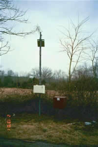
STATION.--395846077040601 ADAMS COUNTY, local well
number AD146LOCATION.--Lat 39`58'45.4", long 77`04'09.0", Hydrologic Unit 02050306, at State Game Land No. 249, and near York Springs.
OWNER.--U.S. Geological Survey.
AQUIFER.--Gettysburg Formation, Late Triassic age.
WELL CHARACTERISTICS.--Drilled observation well, diameter 6 in., depth 100 ft, cased to 17 ft, open hole.
INSTRUMENTATION.--Data collection platform with 15-minute recording interval since April 2023; prior, 60-minute recording interval. Satellite telemetry at station.
DATUM.--Elevation of land surface is 531.5 ft above North American Vertical Datum of 1988, from Lidar. Measuring point: Top of casing, 2.00 ft above land-surface datum.
REMARKS.--Daily maximum, minimum, and mean water levels since October 1994 and water-quality records for 1973-75 are available from the District Office.
Diurnal water-level fluctuations evident during some periods are caused by earth tides.
PERIOD OF RECORD.--January 1968 to current year.
COOPERATION.--Funding for the operation of this station is provided by the Pennsylvania Department of Environmental Protection and the U.S. Geological Survey.
Summary of all available data for this site
Instantaneous-data availability statement
