Warning: Javascript must be enabled to use all the features on this page!


Page Loading - Please Wait...

Click to hideNews Bulletins

USGS 394430077225001 AD 808 Adams County Observation Well

PROVISIONAL DATA SUBJECT TO REVISION

Click to hidestation-specific text


Station gage imageSTATION.--
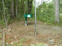
394430077225001 ADAMS COUNTY, local well number AD 808.
LOCATION.--Lat 39`44'29.8", long 77`22'50.1", Hydrologic Unit 02070009, on lot P-176 in Carroll Valley, Adams County, PA.
OWNER.--Carroll Valley Borough.
WELL CHARACTERISTICS.--Drilled observation well, depth 234 ft.
INSTRUMENTATION.--Data collection platform with 15-minute recording interval since April 2023; prior, with 60-minute recording interval. Satellite telemetry at station.
DATUM.--Elevation of land surface is 786 ft above North American Vertical Datum of 1988, from Lidar.
PERIOD OF RECORD.--September 2003 to current year.
This station managed by the PAWSC New Cumberland Office.

Available Parameters Period of Record
  
2003-09-17  2024-04-23


 (365)
 

  -- or --


Summary of all available data for this site
Instantaneous-data availability statement


Depth to water level, feet below land surface


Graph of DAILY Depth to water level, feet below land surface

Add up to 2 more sites and replot for "Depth to water level, feet below land surface"

?


Create presentation-quality graph.