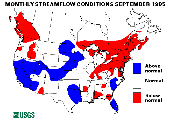
Drought conditions persisted across the Northeast in September 1995. September streamflows were very low, following August monthly rainfalls of only 0.53 inches in Harrisburg, Pennsylvania, 0.76 inches in Allentown, Pennsylvania, and 0.18 inches in New York City, with similar totals across the Northeast. Seven index-streamflow-gaging stations set record minimum monthly mean flows in September, the Hudson River at Hadley, New York, 54 percent; the Mohawk River at Cohees, New York, 41 percent; Massapequa Creek at Massapequa, New York, 21 percent; the Upsalquitch River at Upsalquitch, New Brunswick, Canada, 30 percent; the St. John River below the Fish River at Fort Kent, Maine, 19 percent; the Piscataquis River near Dover-Foxcroft, Maine, 11 percent; and the Little Androscoggin River near South Paris, Maine, 5 percent; of the long-term September median flow.
On September 9, almost 1 inch of rain was recorded at Washington National Airport, Washington D. C.; this was the first measurable rain for 33 days. New England had some rain during the week of September 17-23, which mollified the drought conditions; Boston, Massachusetts, and Providence, Rhode Island, recorded more than 3 inches. More information on the drought conditions can be found at
On heavy rains from Hurricane Luis September 5-6, hit Puerto Rico and the Virgin Islands. Rainfall totals of 8.30 inches near Rio Grande de Loiza and 6.18 inches at Rio Canes Aquas Buenas, Puerto Rico, were recorded. This heavy rainfall caused some flash flooding. On September 15-16, Puerto Rico and the Virgin Islands suffered damage and flash floods from Hurricane Marilyn. Rainfall amounts were as much as 5 to 8 inches from this storm.
The remnants of Pacific Hurricane Ismael caused heavy rainfall in Arizona, New Mexico, and West Texas on September 15. Lubbock, Texas, recorded 4.62 inches, and Hobbs, New Mexico, reported over 7 inches. Flash flooding resulted from this excessive rainfall. The rain from Ismael spread across the Ohio Valley and into New England on September 16-17. Lexington, Kentucky, recorded 2.28 inches of rain on September 16, and, as mentioned above, New England received rain on September 17.
Localized heavy rain caused some flash flooding in many parts of the country. South Florida was repeatedly hit with heavy rains, most notably from September 3 to 9 and on September 25. Other parts of Florida received heavy rains on September 25, especially Daytona Beach, (5.55 inches) and Miami (3.29 inches). On September 18-19, thunderstorms in Nebraska and Kansas dropped more than 5 inches locally that caused flash flooding. Between September 17 and 23, Kodiak, Alaska, received over 10 inches of rain, which included 4.52 inches on September 17 and 2.30 inches on September 19. Augusta, Georgia, received more than 5 inches of rain on September 24, this resulted in some flash flooding and evacuations. Central Starr County, Texas reported more than 10 inches of rain on September 25. On September 28, Tucson, Arizona, received 2.15 inches of rain, which was 129 percent of the September normal total.
Maximum September mean monthly flows were reported at two index- streamflow-gaging stations as a result of delayed mountain snowpack melt and resultant high base flows. These stations are the Beaver River near Beaver, Utah (329 percent of September median), and the Sacramento River at Verona, California (165 percent).
The combined flow of the three largest rivers in the lower 48 States-- the Mississippi, the St. Lawrence, and the Columbia--seasonally decreased seasonally 28 percent from last month to 640,020 cubic feet per second, which is 94 percent of the long-term September median and normal. The Mississippi River at Vicksburg, Mississippi, decreased 41 percent from the August mean but was still 105 percent of the September long-term median.
![]() U.S. Department of the Interior |
U.S. Geological Survey
U.S. Department of the Interior |
U.S. Geological Survey
URL: https://water.usgs.gov/nwc/back_issues/sep95_cov.html
[an error occurred while processing this directive]
Page Contact Information: Water Webserver Team
Page Last Modified: Friday, 08-Jun-2007 16:38:24 EDT
URL: https://water.usgs.gov/nwc/back_issues/sep95_cov.html
Page Contact Information: NatWeb Team (GS_Help_Natweb@usgs.gov)
Page Last Modified: Friday, 08-Jun-2007 16:38:24 EDT