Severe flooding in eastern Texas occurred in mid-October. Thirty-five counties were declared disaster areas. At least 17 deaths were attributed to the storm and flooding. Rainfall totals for the period of October 2 to 22 were over 20 or 30 inches in many locations. College Station received 14.51 inches of rain on October 17 alone. On October 18, some areas north of Houston up to 18.5 inches of rain fell. Flooding on the San Jacinto River caused ruptures in four fuel pipelines, spilling fuel into the river, which then caught fire. Interstate 10 was closed because of these fires
. In the Lavaca River Basin, east of Victoria, Texas, record peak stages and flows occurred. West Mustang Creek near Ganado, Texas, peaked at a stage of 28.39 feet (ft), which is 3.9 ft higher than the previous record. Discharge was estimated to be 30,000 cubic feet per second (ft3/s) which is 3.7 times the 100-year flood. Other record flows were recorded at stations on the Lavaca River near Edna, Texas, and Sandy Creek near Louise, Texas.Six streamflow index gaging stations in the San Jacinto River Basin recorded peak flows in excess of the 100-year flood. A discharge of 354,000 ft3/s was measured at the San Jacinto River near Sheldon, Texas, which is 1.6 times the 100-year flood flow. Three stations in the Trinity River Basin set record peaks; flows at these stations were approximately equal to the 100-year flood.
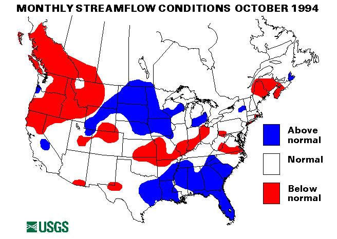
Drought conditions in the interior west moderated during October as a result of above-normal precipitation. However, drought conditions persisted in the Northwest and in Puerto Rico. Flows at the following streamflow index stations were below normal for at least six consecutive months:
North Fork American River at North Fork Dam, California
White River near Meeker, Colorado
Salmon River at White Bird, Idaho
Clearwater River at Spalding, Idaho
Umpqua River near Elkton, Oregon
Columbia River at The Dalles, Oregon
Green River at Green River, Utah
Spokane River at Spokane, Washington
The mean flow at the Rio Grande de Manati at Highway 2 near Manati, Puerto Rico, set a new monthly mean minimum for October. This was the eighth new monthly minimum mean flow in the last 13 months for this station.
A new record minimum October monthly mean flow also was set at the Massapequa Creek at Massapequa, New York, streamflow index gaging station. New record maximum October monthly mean flows were set at the Northeast Margaree River at Margaree Valley, Nova Scotia, Canada, the Alapaha River at Statenville, Georgia, the Altamaha River at Doctortown, Georgia, and the Neches River near Rockland, Texas.
The combined flow of the three largest rivers in the lower 48 States--the Mississippi, the St. Lawrence, and the Columbia--decreased by 2 percent from last month to 624,680 ft3/s. This flow is 90 percent of the long-term October median and in the normal flow range.
Lake Ontario was at a level of 245.34 ft above National Geodetic Vertical Datum, which is below normal for October. Lakes Superior, Huron, and Erie were in the normal range.
![]() U.S. Department of the Interior |
U.S. Geological Survey
U.S. Department of the Interior |
U.S. Geological Survey
URL: https://water.usgs.gov/nwc/back_issues/oct94_cov.html
[an error occurred while processing this directive]
Page Contact Information: Water Webserver Team
Page Last Modified: Friday, 08-Jun-2007 16:38:19 EDT
URL: https://water.usgs.gov/nwc/back_issues/oct94_cov.html
Page Contact Information: NatWeb Team (GS_Help_Natweb@usgs.gov)
Page Last Modified: Friday, 08-Jun-2007 16:38:19 EDT