The Iowa, Nishnabotna, and Des Moines Rivers rose above flood stage after rainfall up to 2 inches on May 1-2. The Iowa River fell back below flood stage on May 7.
Minor flooding along the Missouri River in South Dakota, Nebraska, Iowa, and Missouri persisted during the entire month of May. This flooding affected lowland areas and showed minor rises and falls due to local rainfall and changes in reservoir releases.
Heavy rainfall from thunderstorms on May 16-18 caused rapid rises in creeks and streams in parts of Iowa and Kansas. Rainfall totals were up to 6 inches. Roadways were flooded in many parts of Kansas.
Flash flooding from up to 3 inches of rain on May 22 caused problems in Kimball County, Nebraska. This same county received over 6 inches of rain on May 24.
Heavy rainfall up to 3 inches on May 30 caused flash flooding near Dodge City, Kansas. Many cars were stranded and a child had to be rescued from a flooded drainage ditch.
Western Great Lakes Region
Minor flooding along the Mississippi River from Keithsburg to Chester,
Illinois, continued through May 14. The river was only a few feet above
flood stage.
Heavy rainfall on May 30-31 across Illinois caused widespread flash flooding. The Big Muddy River crested nearly 9 feet over flood stage.
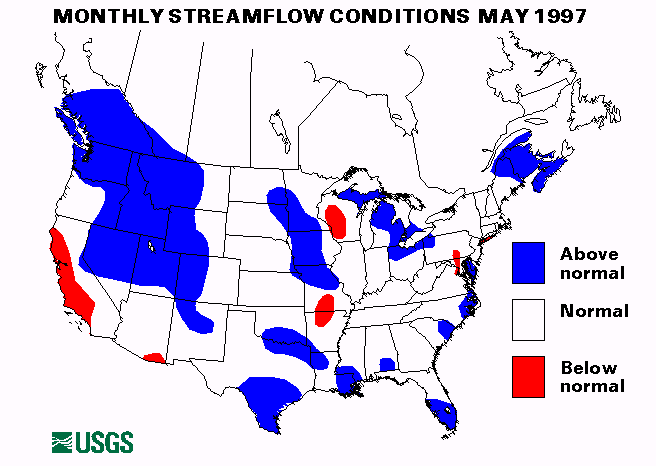
The index streamflow gaging station on the Minnesota River near Jordan, Minnesota, has had above-normal flow for seven consecutive months.
New England and New York Region
The St. John River in Maine crested 2 to 3 feet over flood stage on May 7
following snowmelt in the basin.
Mid-South Region
Heavy rainfall from thunderstorms on May 2-3 caused flash flooding in
Alabama, Mississippi, and Tennessee. Some evacuations were necessary in
Alabama. Rainfall totaled from 2 to 6 inches.
Thunderstorms caused flash flooding in parts of Mississippi and Kentucky on May 20. bay St. Louis, Mississippi, received 9 inches of rain with 6 inches falling in 3 hours.
Rainfall totals of 6 to 8 inches across parts of Alabama, Mississippi, and Tennessee, caused flash flooding problems and flood stage to be exceeded on the Tombigbee River in Alabama, and the Tallahatchie River in Mississippi on May 29. Parts of Alabama received another 4 inches of rain on May 30-31 which aggravated the flooding situation.
Mid-Continent South Region
Heavy rainfall from thunderstorms up to 4 inches at rates of up to 1
inch/hour caused flash flooding across Arkansas, Louisiana, and Texas on
May 2-3. Carthage, Texas, reported 5 inches of rain in one hour.
Up to 2 inches of rain in the Canadian River basin in Texas caused rapid rises to above flood stage all along the river on May 7.
On May 8, rainfall totals of over 6 inches and rates of 1.75 inches/hour caused flash flooding in parts of Oklahoma and Missouri.
On May 9, as much as 4-5 inches of rain in parts of north Texas caused flash flooding. A new record, 9 feet above flood stage was measured on the South Wichita River near Benjamin, Texas.
Heavy thunderstorms dropped rain at rates of 2 inches/hour on Kerr and Real Counties, Texas, on May 13 causing local flooding. Another round of thunderstorms on May 125 caused widespread flash flooding around San Angelo and San Antonio, Texas. Trinity County, Texas, received up to 6-7 inches of rain on May 16.
On May 17-18, heavy thunderstorms drenched parts of Missouri. Up to 3-4 inches of rain fell in 4 hours in Benton, Manes, Phelps, Pulaski, Adair, Knox, and Miller Counties. Some flash flooding was reported and rises were experienced on the Osage River.
On May 20, thunderstorms dropped rain at rates of 2 to 3 inches/hour across parts of Arkansas, Louisiana, and Texas, causing widespread flash flooding.
Much of Texas was drenched with heavy rainfall up to 10 inches on May 22. Roads were flooded in Marathon, Austin, and Houston, Texas. Up to 4 more inches of rain fell in the same areas on May 23.
Several homes were flooded in New Iberia, Louisiana, on May 25 when over 4 inches of rain fell in 3 hours. Oklahoma, Missouri, and Texas also saw heavy rainfall over the Memorial Day weekend with isolated totals over 7 inches. Flash flooding was widespread.
More thunderstorms hit parts of Arkansas and Texas with up to 6 inches of rain on May 28. Flooding was reported along the Red Bluff and Sycamore Creeks in Texas.
Thunderstorms again drenched parts of Missouri, Oklahoma, Louisiana, and Texas on May 30-31. Rainfall intensity was estimated at some places up to 3 inches/hour. Evacuations were required in Marble Hill and Lutesville, Missouri.
Despite heavy rainfall across the surrounding area, the streamflow index station on the Buffalo River near St. Joe, Arkansas set a new minimum May mean monthly flow of 321 cubic feet per second (cfs), 28 percent of the long term median (1961-90).
Atlantic Southeast Region
On May 2-3 heavy rainfall in Cherokee County, North Carolina and northern
Georgia caused flash flooding. The Oostanaula River in Georgia rose above
flood stage.
Intermountain West Region
Warm temperatures and scattered showers produced snowmelt runoff in Idaho
along the St. Joe and Coeur D'Alene Rivers and Bitterroot River in
Montana from May 7-31. Minor flooding was also experienced along the
Henry's Fork, Portneuf, and Snake Rivers in Idaho, the Green and Logan
Rivers in Utah, and the Flathead River and Ashley Creek in Montana. On
May 19, record streamflow was measured on the Clark Fork at St. regis,
Montana, when 70,700 cfs was recorded. This gage has been operated since
1910. This flood was about a 50-year recurrence interval flood.
For more information about flooding in
Montana
On May 16, thunderstorms produced up to 5 inches of rain across Owyhee County, Idaho, which caused flash flooding problems.
Five inches of rain caused flash flooding in Logan and Weld Counties, Colorado, on May 24.
Heavy rains in Idaho caused rapid rises on the Teton and Henry's Fork Rivers to above flood stage on May 30. Warm temperatures causing snowmelt further added water to the already high rivers. Rains and snowmelt also caused flooding in northwestern Colorado along the Yampa River and Fortification Creek. All four streamflow index stations in Idaho have had above-normal flows for at least 5 consecutive months. New May maximum monthly mean flows were established on the Snake River near Heise, Idaho, and the Salmon River at White Bird, Idaho, with flows 200 and 191 percent of median, respectively.
Northwest Region
Snowmelt and showers caused some flooding in eastern Oregon and
Washington in mid-May. Most flooding was minor. Rivers affected were the
Spokane, Okanogan, and Naches in Washington and the Imnaha, Lostine, and
Wallowa in Oregon.
Eastern Great Lakes Region
Heavy rainfall caused flooding problems in Indian and Ohio on May 20.
rapid rises were reported on the Eel and St. Joseph Rivers in Indiana.
Over 6 inches of rain in Adams and Scioto Counties, Ohio, caused creeks
to rise. Cars were stranded and rescues required in several areas.
Northern Illinois, Indiana, and Ohio received up to 4 inches of rain on May 25. Rapid rises were seen in many small streams and evacuations were necessary in parts of Allen County, Ohio.
Heavy rainfall on May 30-31 across indian and Ohio caused flash flooding and bankfull streams. many roads were closed. The Ohio River rose above flood stage from Tell, Indiana, to Cairo, Illinois because of heavy tributary inflow. The White River in Indiana also rose sharply to above flood stage. The Cuyahoga River in Ohio was expected to rise to near record levels.
Mid-Atlantic Region
May 25 saw heavy rainfall in Pennsylvania, Maryland and northern
Virginia. Rainfall totals over 3 inches caused street flooding in the
Pittsburgh, Pennsylvania, and Washington, District of Columbia, areas.
Southwest Region
The index station of the West Walker River below Little Walker River near
Coleville, California, has had above-normal flows for seven consecutive
months.
Southern California, however, has been very dry. No measurable rain has been recorded at the Los Angeles Civic Center since February 17.
Alaska
Three of the four streamflow index sites in Alaska had normal flow. The
Little Susitna River near Palmer, Alaska, was above-normal with 159
percent of the long-term median for May.
Hawaii
Two of the three reporting streamflow index sites in Hawaii were
above-normal in May. The East Branch of North Fork Wailua River near
Lihue, Kauai, Hawaii, was 189 percent of median. Kalihi Stream near
Honolulu, Oahu, Hawaii, was 196 percent of median.
Puerto Rico
Both streamflow index sites in Puerto Rico were below normal. The Rio
Grande De Manati at Highway 2 near Manati, Puerto Rico, was 41 percent of
median and the Rio Inabon at Real Abajo, Puerto Rico, was 39 percent.
Big Three Rivers
The combined flow of the three largest rivers in the lower 48 states--
the St. Lawrence, the Mississippi, and the Columbia--decreased 1percent
from April to 1,792,000 cubic feet per second (ft3/s),. which was 122 percent of median. This flow
is in the normal range. The Columbia River at The Dalles, Oregon
increased 190 percent from last month but this increase was more than
offset by a 37 percent decrease in the flow of the Mississippi River near
Vicksburg, Mississippi.
![]() U.S. Department of the Interior |
U.S. Geological Survey
U.S. Department of the Interior |
U.S. Geological Survey
URL: https://water.usgs.gov/nwc/back_issues/may97_cov.html
[an error occurred while processing this directive]
Page Contact Information: Water Webserver Team
Page Last Modified: Friday, 08-Jun-2007 16:38:07 EDT
URL: https://water.usgs.gov/nwc/back_issues/may97_cov.html
Page Contact Information: NatWeb Team (GS_Help_Natweb@usgs.gov)
Page Last Modified: Friday, 08-Jun-2007 16:38:07 EDT