Edges and remnants of these same storms caused flash flooding in Nevada, Utah, and Arizona as well, particularly on March 11-12. Flooding was extensive in the Santa Clara River and Beaver Dam Wash Basins in southwestern Utah.
Heavy rainfall from 4 to 8 inches caused isolated minor flash flooding throughout the southeast during the week of March 12 through 18. Louisiana, Mississippi, Arkansas, and Florida were hit the hardest.
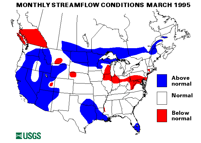
Snowmelt and ice-jam flooding occurred from middle to the end of the month across many of the northern tier states. North Dakota, South Dakota, Minnesota, and Iowa reported the most problems with flooding on the James, Sheyenne, Maple, Wild Rice, Red, Snake, Iowa, Minnesota, Buffalo, and Pembina Rivers, as well as many smaller streams. Other minor flooding was reported in Wisconsin, Michigan, New York, and Vermont. A new March maximum monthly mean was recorded at the index-gaging station on the Red River of the North at Grand Forks, North Dakota, of 15,350 cubic feet per second. This flow is 738 percent of the 1961-90 long-term median for March.
A new March maximum monthly mean was also reported for Saline Bayou near Lucky, Louisiana. New March minimum monthly mean flows were reported at index-gaging stations on the Little Susitna River near Palmer, Alaska, and Massapequa Creek at Massapequa, New York. The Massapequa Creek station has had below median flows since May 1993 and has established four new minimum monthly mean flows in that period.
The combined flow of the three largest rivers in the lower 48 states-- the Mississippi, the St. Lawrence, and the Columbia--increased by 66 percent from last month to 1,676,300 cubic feet per second. This flow is 127 percent of median and above normal for March.
![]() U.S. Department of the Interior |
U.S. Geological Survey
U.S. Department of the Interior |
U.S. Geological Survey
URL: https://water.usgs.gov/nwc/back_issues/mar95_cov.html
[an error occurred while processing this directive]
Page Contact Information: Water Webserver Team
Page Last Modified: Friday, 08-Jun-2007 16:38:01 EDT
URL: https://water.usgs.gov/nwc/back_issues/mar95_cov.html
Page Contact Information: NatWeb Team (GS_Help_Natweb@usgs.gov)
Page Last Modified: Friday, 08-Jun-2007 16:38:01 EDT