Mid-Continent South Region
Heavy rainfall in Missouri on June 4 caused flash flooding problems in
many counties, most notably Maries and Camden. St. Louis received 2.47
inches of rain and Columbia, 2.42 inches, to establish new daily records.
River flooding along the Big, Lamine, Moreau, Maries, and Meramec Rivers
followed this heavy rain.
The heavy rains caused the Missouri River to rise slightly above flood stage from Nebraska City, Nebraska to Waverly, Missouri, on June 12. The river remained near flood stage through the end of June.
Severe drought conditions continued across south Texas. Corpus Christi, Texas, recorded only 0.06 inches of rain from March 17- June 13. Some rains did help ease conditions in the last half of June.
5 to 10 inches of rain were reported in the Addington, Oklahoma area on June 18-19. On June 20 many parts of Missouri reported over 5 inches of rain.
Mid-South Region
Most of Tennessee experienced flash flooding problems following very
heavy rainfall on June 4-5. Camden reported 6.55 inches of rain and
Nashville recorded 5,23 inches in 24 hours. On June 6, evacuations were
necessary after two levees broke along the North Fork of the Obion River
near Rives, Tennessee.
Kentucky and Tennessee were hit with heavy rainfall again on June 8-9. Some areas received up to 5 inches of rain with flash flooding closing roads and requiring evacuations in Johnson and Breathitt Counties, Kentucky. Paducah, Kentucky, set a single day June record with 4.32 inches of rain.
Heavy rainfall fell again over parts of Kentucky on June 11. Evacuations were necessary downstream of Doe Run Creek Dam in Kenton county after floodwaters filled the spillway of that dam.
Localized urban, flash, and small stream flooding followed torrential rain across Kentucky on June 22. Bridges and roads were washed out in Harrison, Bourbon, and Clark Counties. Flash flooding also forced evacuations in Hampton and Valley Forge, Tennessee, after these heavy rainstorms.
Southeast Atlantic Region
Boone, North Carolina, had flooded streets and bridges following heavy
rainfall on June 4-5.
Florida suffered through an extended dry period in June with many wildfires forcing evacuations and destroying homes and property. Interstate 95 was closed periodically due to the fires and smoke. Almost 50,000 people had to be evacuated at one time or another. Streamflow rates were for the most part normal as a consequence of high flows over the winter maintaining high base flows.
Palm Beach County, Florida, received 4-6 inches of rain on June 8-9 causing some flash flooding problems.
Heavy rainfall on June 9-10 caused flash flooding problems in Smyth and Tazewell Counties in Virginia.
Heavy rainfall on June 15 caused flash flooding in Lincoln and Kanawha Counties, West Virginia. On June 19, Lewis County, West Virginia, reported extensive flooding following intense thunderstorms. The West Fork, Tygart Valley and Buckhannon Rivers experienced rapid rises. Evacuations along the Holley and Elk Rivers in Braxton County were needed on June 20.
Widespread flash flooding followed rainfall of 5 to 6 inches across much of West Virginia on June 28. Two deaths resulted in Frame, West Virginia. Clendenin and Sissonville, West Virginia, were particularly hard hit.
Mid-Continent North Region
The Omaha/Council Bluffs, Nebraska, area received over 3 inches of rain
on June 8-9 causing flash flooding. The Nishnabotna River in Nebraska was
at or near flood stage. agricultural flooding was also experienced along
the Raccoon River in Iowa.
Many parts of Iowa received up to 4 inches of rain on June 10 causing localized flash flooding.
On June 14, Atlantic, Iowa received a state record 13.18 inches of rain causing record flooding on the Nishnabotna River at Hamburg, Iowa. The crest was 15.2 feet above flood stage and 2.6 feet higher than the 1993 flood peak. Another storm brought up to 6 more inches of rain on June 15 aggravating the situation. The Raccoon River crested at its second highest peak on record. The East Nishnabotna River at Red Oak, Iowa, crested almost 1.2 feet above the previous record set in 1947.
The Fargo, North Dakota, area received 4 inches of rain on June 18 causing localized flash flooding.
Precautionary evacuations along Shell Creek near Newman Grove, Nebraska, followed heavy rains and stream rises on June 18.
More rain fell over parts of Iowa on June 20. some areas reported 4-5 inches of rain which aggravated the previously existing flooding along the Cedar, Iowa, Nishnabotna, and Skunk Rivers.
Linn County, Kansas, received as much as 7 inches of rain on June 22. Widespread flash flooding resulted. Gage, Hayes Jefferson, and Lincoln Counties in Nebraska reported localized flooding on June 22 following 3 inches of rain.
Heavy rains in Iowa and Kansas on June 23 caused flooding along the Boyer River in Iowa and in Wyandotte County, Kansas.Up to 3 to 5 inches of rain fell in a 6 hour period.
On June 24, Aberdeen, South Dakota, received up to 2 inches of rain in one hour flooding streets and low-lying areas.
Western Great Lakes Region
LaSalle County, Illinois, received up to 4 inches of rain on June 10-11
causing street and flash flooding.
On June 11-12, Brainerd, Minnesota, was hit with localized flooding after thunderstorms dropped very heavy rainfall.
Rainfall in the first part of June brought many rivers in Illinois over flood stage. The Wabash River crested from 6.5 to 12.5 feet above flood stage. The Mississippi River also rose above flood stage from Hannibal, Missouri, to Chester, Illinois. Several locations along the Ohio River also rose above flood stage.
LaSalle County, Illinois, again received up to 6 inches of rain in 3 hours on June 16 causing widespread flash flooding.
Heavy rains on June 20 caused evacuations from a nursing home in Maybell, Minnesota.
From 3-10 inches of rain fell in portions of Boone, Winnebago, McHenry and Lake counties, Illinois, from June 24-26. Widespread flash flooding and aggravated river flooding resulted.
On June 27, 6 to 7 inches of rain fell south of the Twin Cities in Minnesota causing widespread flash flooding problems.
On June 29, up to 9 inches of rain was reported in Williamson County in southern Illinois causing flash flooding problems.
The Wabash River at Mount Carmel, Illinois, streamflow index site set a new maximum June monthly mean flow of 80,120 cubic feet per second (cfs).
Eastern Great Lakes Region
Heavy rains hit Indiana and Ohio on June 11. Rainfall totals of 4-6
inches were reported. Wildcat Creek near Lafayette, Indiana, caused
extensive flooding. Flash flooding was widespread over Indiana and
western Ohio.
Heavy rainfall from June 14-15 caused flash flooding and river flooding in parts of Ohio. Homes along Black Creek in Holmes County had to be evacuated. Several mudslides were also reported.
On June 22, 1 to 5 inches of rain on already saturated soils caused localized flash flooding and rapid rises on streams over much of Indiana. Ripley county was particularly hard hit. The White River at Hazelton, Indiana, reached its highest level since 1945.
Very heavy rainfall up to 11 inches fell over much of Indiana and Ohio on June 26-28. Eight inches of rain fell in 2 hours near Spencer, Indiana. Major flooding in Ohio caused three deaths and millions of dollars in damages. Coshocton, Muskingum, Licking, Guernsey, Belmont, Tuscarawas and Monroe counties in Ohio were the hardest hit. For further information on the flooding in Ohio see http://www-oh.er.usgs.gov ews.html. Record flooding was recorded along Wills Creek at Cambridge, Ohio, with a peak of 12 feet above flood stage. The entire village of Byesville, Ohio, was evacuated, as were 300 people in Uhrichsville, Ohio.
The streamflow index station on the East Fork White River at Shoals, Indiana, set a new maximum June monthly mean flow of 18,100 cfs
Intermountain West Region
A highway was washed out by heavy rains on June 11 near the Gem
County/Boise County, Idaho, line.
Heavy thunderstorms dropped 4.5 inches of rain in Campbell County, Wyoming, and over 3 inches in Weston County, Wyoming, on June 22. Flash flooding was widespread in these counties.
New York and New England Region
Extremely heavy rainfall hit New England and upstate New York on June
12-15. Sharon, Massachusetts received 10.30 inches of rain during the
storm. Many rivers across the region rose above flood stage. The Wading
River near Norton, Massachusetts peaked on June 14 with a discharge of
1,460 cfs which had a recurrence interval of about 80 years. More
information is available at
Massachusetts
and
Rhode Island.
Eastern and southern New Hampshire received more than 7 inches of rain from June 13-17. A peak in excess of the 50-year flood was recorded on the Bear Camp River at South Tamworth, New Hampshire, on June 14. Many other rivers had flood peaks in the 10-25-year recurrence interval range. More information is available at New Hampshire
On June 19, 3-4 inches of rain fell in 2 hours in Somerset County, Maine, causing flash flooding and basement flooding.
Heavy rainfall on June 25 caused flash flooding problems near Beemantown, New York. Rainfall rates of 1 to 2 inches per hour were reported.
Heavy rainfall across northern New York and New England on June 27 caused extensive flooding. Greater than 100-year floods were reported on Ayers Brook at Randolph, Vermont, and on the New Haven River near Middlebury, Vermont. These floods were the highest peaks on record. Flash flooding was experienced in many parts of New York, Vermont, New Hampshire and Maine. More information is available at Vermont.
Southwest Region
Rainfall and snowmelt in the Sierras forced the evacuation of campgrounds
along the Merced River in Yosemite National Park on June 15.
The streamflow index stations at Arroyo Seco near Pasadena, California, and the Sacramento River at Verona, California, both set new maximum June mean monthly flow records.
Mid-Atlantic Region
Heavy rainfall of as much as 4 inches of rain in just over an hour and a
half caused flash flooding problems in western Pennsylvania from june
19-21. Mill Creek in Westmoreland County forced evacuations in Ligoner,
Pennsylvania, on June 19.
Flash flooding occurred after 1.1 inches of rain fell in 30 minutes near Damascus, Maryland, on June 23. Flash flooding was also experienced across much of Pennsylvania on that date due to heavy rainfall. Evacuations were necessary in Tioga, Pennsylvania.
Alaska
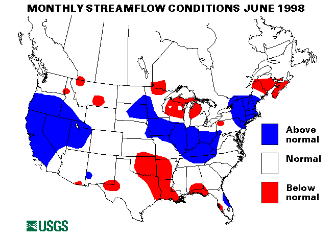
The Kenai River at Cooper Landing, Alaska, streamflow index site was
above-normal flow for June. The Chena River at Fairbanks, Alaska, and the
Tanana River at Nenana, Alaska were both below-normal for June. The
Little Susitna River near Palmer, Alaska, was in the normal range.
Hawaii
All three streamflow index sites in Hawaii were above-normal for June.
![]() U.S. Department of the Interior |
U.S. Geological Survey
U.S. Department of the Interior |
U.S. Geological Survey
URL: https://water.usgs.gov/nwc/back_issues/june98_cov.html
[an error occurred while processing this directive]
Page Contact Information: Water Webserver Team
Page Last Modified: Friday, 08-Jun-2007 16:37:56 EDT
URL: https://water.usgs.gov/nwc/back_issues/june98_cov.html
Page Contact Information: NatWeb Team (GS_Help_Natweb@usgs.gov)
Page Last Modified: Friday, 08-Jun-2007 16:37:56 EDT