On June 1, besides the flooding on the Ohio, the Missouri, and the Mississippi Rivers, tributary streams in Illinois and Missouri also were flooding was major in tributary. In Missouri, the Meremec River at Arnold, was 13.6 feet (ft) above flood stage, and the Osage River at Schell City, was 11.7 ft above flood stage. In Illinois, the Illinois and the Big Muddy Rivers, were more than 15 ft above flood stage at some locations. Flash flooding was widespread in Texas, Louisiana, and Mississippi that followes local thunderstorms that brought from 3 to 6 inches(in.) of rain. Leesville, Louisiana recorded 8.43 in. of rain in a 96-hour period.
Hurricane Allison hit the panhandle of Florida, Georgia, and South Carolina between June 5 and 7. Rainfall amounts of as much as 8 in. were reported, but because of dry antecedent conditions, flooding was only minor. Some people there evacuated but the rainfall was generally beneficial in the affected area.
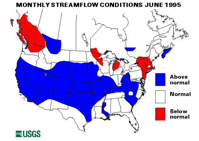
Heavy rain on a heavy snowpack caused some major flooding on the North Fork Flathead River near Columbia Falls, Montana, on June 7th. Peak flows with recurrence intervals of greater than or ewual to 30 years also were recorded on the Swiftcurrent Creek at Many Glacier, the St. Mary River at International Boundary, and the Two Medicine River below South Fork near Browning, Montana. For more information, see the Montana District home page.
URL="http://wwwdmthln.cr.usgs.gov/www/flood_report_mel.html"
On June 8, heavy rainfall from thunderstorms caused near-record flooding on the Red River above Texoma on the Texas Oklahoma border. The Marais des Cygnes River in Kansas peaked at 8 ft above flood stage. On June 9, the Little Arkansas, the Whitewater, and the Walnut Rivers in Kansas were about 10 ft above flood stage. On June 12 13, the North Canadian River in Oklahoma had near-record peaks, and the Deep Fork River at Beggs, Oklahoma, crested at 11 ft above flood stage. The Red River at Gainesville, Texas, was 12 ft above flood stage.
Throughout June, mountain snowmelt caused some minor flooding problems in the Rockies. The greater-than-normal snowpack and delayed melt caused many rivers in California, Nevada, Utah, Idaho, Wyoming, Montana, Colorado, and New Mexico to be bankfull. Only minor problems were reported, but higher flow conditions are persisting much longer than normal in these areas.
From June 23 to 26, torrential rains fell on central and southeastern Florida. As much as 15 in. of rain fell in this area, and flooding closed highways, disrupted water supplies, and caused some evacuations in the Miami and the Tampa areas.
Heavy rainfall caused flooding in Virginia and North Carolina from June 23 to 30. Lynchburg, Virginia, received from 3 to 8 in. of rain on June 23, which caused flooding with about a 30-year-recurrence interval on the Maury River near Buena Vista, Virginia. Timber Lake Dam broke and caused a flow of 90,000 cubic feet per second (ft3/s) on the Big Otter River near Evinston, Virginia, which corresponded to a natural flood with a greater-than-500 year recurrence interval. Two deaths were reported from this dam break. More heavy rains on June 27 caused near-record flooding on the Rapidan, the Shenandoah, and the upper Potomac Rivers. At a former USGS streamflow-gageing station on the Rapidan River near Ruckersville, Virginia, a peak flow was estimated to be 100,000 ft3/s on a peak stage of 31.6 ft; the previous measured extreme was 30,700 ft3/s and 20.8 ft in October 1952. This year's peak was in excess of a 500-year flood. Rains of as much as 9.5 in. in Greensboro, North Carolina, on June 29 caused floods with about a 25-year-recurrence interval on the Haw River at a stage of 26.5 ft, 8.5 ft above flood stage. More information on the flooding in Virginia and North Carolina can be found at,
URL="http://water.usgs.gov/flood_va.html"
URL="http://ser1dncrlg.er.usgs.gov ews/flood.html"
Streamflows remain below normal in the Northeast and New England. Vermont had the driest June in 101 years of record.
New June maximum monthly means were recorded at three streamflow index-gaging stations. Contentnea Creek at Hookerton, North Carolina, the Arkansas River at Arkansas City, Arkansas, and the Washita River near Dickson, Oklahoma. The median June flows of the Arkansas and the Washita Rivers were 703 and 800 percent, respectively. A new minimum June monthly mean was reported on the Skeena River at USK, British Columbia, Canada.
The combined flow of the three largest rivers in the lower 48 States-- the Mississippi, the St. Lawrence, and the Columbia--increased 39 percent from last month to 2,118,000 ft3/s, which is 150 percent of the long-term June median and above normal. The Mississippi River at Vicksburg, Mississippi, increased 57 percent from last month and was 235 percent of median.
![]() U.S. Department of the Interior |
U.S. Geological Survey
U.S. Department of the Interior |
U.S. Geological Survey
URL: https://water.usgs.gov/nwc/back_issues/june95_cov.html
[an error occurred while processing this directive]
Page Contact Information: Water Webserver Team
Page Last Modified: Monday, 13-Jul-2009 14:02:47 EDT
URL: https://water.usgs.gov/nwc/back_issues/june95_cov.html
Page Contact Information: NatWeb Team (GS_Help_Natweb@usgs.gov)
Page Last Modified: Monday, 13-Jul-2009 14:02:47 EDT