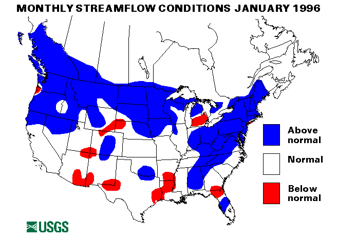
Between January 18 and 20, warm temperatures, heavy rain, and a rapidly melting snowpack caused rapid runoff, when combined with ice breakup and jams, resulted in widespread major flooding. Rivers and streams were over flood stage from Wisconsin to North Carolina to Maine. Flooding was severe on the Delaware, the Susquehanna, the Upper Ohio, the Potomac and the James Rivers. In Williamsport, Pennsylvania, were 3.03 inches of rain recorded between January 18 and 19 more than 20 inches of snow. Ice jams further aggravated flooding at many locations.
New January maximum monthly means were set at 11 index-gaging sites in the Northeast and the Middle Atlantic States. These new maximums included the Piscataquis River near Dover-Foxcroft, Maine (1,441 cubic feet per second, 667 percent of the long-term median) the Susquehanna River at Harrisburg, Pennsylvania (127,300 cubic feet per second = 540 percent, peak daily discharge of 568,000 cubic feet per second on January 20), the Potomac River near Washington, D.C. (53,400 cubic feet per second = 472 percent, peak daily flow of 326,600 on January 21), the Rappahannock River at Remington, Virginia (2,956 cubic feet per second = 407 percent, peak daily at 31,300 cubic feet per second on January 20), and the Kanawha River at Kanawha Falls, West Virginia (39,700 cubic feet per second = 254 percent, peak daily at 105,000 cubic feet per second on January 20). Five other index-gaging stations outside the severe flooding area also had maximum January monthly means. See the Monthly Extremes table elsewhere in this document for a complete listing of these flows.
Heavy rainfall in the Ohio Valley and the New England States the week of January 21-27 caused or aggravated flooding problems. The Ohio River at Cincinnati crested 5.3 feet above flood stage on January 25. This was the highest peak since March 1979. This peak travelled down river and passed Paducah, Kentucky, by the early part of February. Heavy snows fell in the Sierra Nevadas and the Rockies, particularly in the Wasatch Range in Utah from January 14 through 27. Average snowpack in the Sierra Nevadas went from 33 percent of normal on January 11 to 90 percent of normal on January 28. On January 24 and 25, Salt Lake City, Utah, received 16.5 inches of snow; this broke a January record of 10 inches set only a week earlier. Elko, Nevada, received 20.9 inches in the same storm.
Combined flow in the three largest rivers in the contiguous 48 States-- the St. Lawrence, the Mississippi, and the Columbia--rose one percent from last month to 866,000 cubic feet per second. This is 89 percent of the long-term January median and in the normal range. The flow of the Columbia River at the Dalles, Oregon, was 163 percent of median despite dropping 37 percent from the flow in December.
![]() U.S. Department of the Interior |
U.S. Geological Survey
U.S. Department of the Interior |
U.S. Geological Survey
URL: https://water.usgs.gov/nwc/back_issues/jan96_cov.html
[an error occurred while processing this directive]
Page Contact Information: Water Webserver Team
Page Last Modified: Friday, 08-Jun-2007 16:37:44 EDT
URL: https://water.usgs.gov/nwc/back_issues/jan96_cov.html
Page Contact Information: NatWeb Team (GS_Help_Natweb@usgs.gov)
Page Last Modified: Friday, 08-Jun-2007 16:37:44 EDT