Steady rain in eastern Washington and Oregon again brought small streams to or above flood stage on February 18-19.
Western Great Lakes Region
The Ohio River downstream of the confluence with the Wabash River was
over flood stage from February 1-5 following last month's flooding in
Indiana and Illinois. Only minor flooding was experienced at this time.
Following heavy rainfall in the Ohio Valley and snowmelt, the Ohio River rose back over flood stage from Shawneetown, Illinois, to Cairo, Illinois. On February 10, the Ohio River at Shawneetown was at 35.8 feet, 2.8 feet over flood stage. The river dropped below flood stage on February 12.
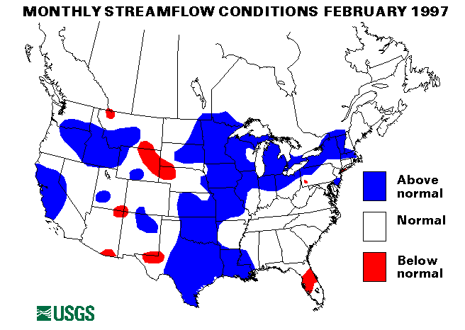
Heavy rainfall and snowmelt, combined with frozen ground, caused severe flooding in Illinois and Wisconsin beginning on February 19. The Grant River in Wisconsin rose 18.7 feet in 15 hours to a crest 6.6 feet above flood stage on that date. In Illinois, the Rock River reached record levels 6.77 feet above flood stage at the streamflow index gage near Joslin. Ice jams on the Rock River aggravated the flooding conditions. The Illinois River and the Pecatonica River also experienced significant flooding. Flooding on the Illinois River was comparable to the flooding during the summer of 1993. Crests were not expected on the lower Illinois until early March. Additional rainfall of 1 to 2 inches on February 27 pushed the already swollen rivers even higher. Peaks were expected over 10 feet above flood stage at some locations. Further information on the flooding in Illinois is available at (http://wwwdilurb.er.usgs.gov/). The Rock River near Joslin, Illinois, gage set a new maximum February mean monthly flow with 14,610 cubic feet per second (ft3/s), 313 percent of the long-term February median.
The Ohio River at Cairo, Illinois, rose above flood stage again on February 26 due to the heavy tributary inflows and backwater effects from the Mississippi River.
Mid-Continent South Region
On February 3, heavy thunderstorms dropped up to 1.5 inches of rain per
hour and caused flash flooding in parts of Arkansas, especially in the
Fort Smith area.
Heavy rainfall over Texas and Louisiana on February 12 caused many flash flooding problems and rises on numerous streams. Rainfall totaled up to 4 to 6 inches in 18 hours. The Little River in Louisiana was over 4 feet above flood stage. Moderate flooding was experienced along the Attoyac Bayou in Texas. This heavy rainfall plus water coming downstream from the Ohio River caused the Mississippi River at Red River Landing, Louisiana, to rise over flood stage on February 15.
Rainfall totals up to 5 inches, with rates up to 2.5 inches per hour were reported in central Texas on February 20. Flash flooding was widespread particularly in urban areas. Flood waves were reported in Johnson Draw and the Devil's River drainages.
On February 21, 2 to 3 inches of rain, with isolated reports of more than 5 inches, fell across much of Arkansas, Missouri, Oklahoma, Texas, and Louisiana. Severe flash flooding was common across the area and moderate to severe flooding was experienced along Lee Creek in Arkansas, Glover River and Little River in Oklahoma, and the Llano River in Texas. The Poteau River near Poteau, Oklahoma, crested over 4 feet above flood stage. Major flooding also occurred along the Lower Washita and Blue Rivers in Oklahoma.
The Missouri and Mississippi Rivers both were over flood stage in Missouri after February 21 due to tributary inflow. Major flooding at Boonville, Missouri, caused some problems. Additional heavy rainfall on February 27 prolonged the peaks and kept the rivers above flood stage.
On February 24, 2 to 5 inches of rain fell across parts of Louisiana. Several rivers rose above flood stage including the Tchefuncta river near Folsom, Louisiana, where evacuations were necessary. Some moderate flooding also was reported along the Pearl and Bogue Chito Rivers.
Mid-South Region
Heavy rains from thunderstorms caused localized flooding on
small streams across Kentucky and Tennessee on February 3-4.
Rainfall rates up to 1.5 inches in an hour and a half were reported.
On February 5, 2-3 inches of rain on already saturated ground caused flooding on the Green and Licking Rivers in Kentucky.
New England and New York Region
Ice jams flooding was reported on Cazenovia Creek in western New York on
February 5 through February 20 after melting snow and rain broke up the
stream's ice cover. Ice jam flooding was also reported on Allen's Creek
near Brighton, Monroe County, New York on february 6.
On February 22, melting snow and rain with ice jams caused flooding along the Ausable River in New York.
Mid-Atlantic Region
Ice jam flooding along Red Bank creek in western Pennsylvania was
reported on February 5. Ice jams along the West Branch Susquehanna River
in Clearfield, Pennsylvania, closed several roads on February 6.
Ice jams were also a problem along the Allegheny River on February 6.
Eastern Great Lakes Region
Ice jams and flows in the Wabash River and White River in Indiana caused
lowland flooding near Lafayette on February 6-12. The White River fell
below flood stage on February 12 and the Wabash River on February 13.
Heavy rains of 1 to 4 inches caused widespread flooding of low lying areas across southern Michigan on February 21.
Heavy rains from February 22-23 and again on February 26-27 caused flooding in Indiana along the Kankakee, Tippecanoe, Wabash, and St. Joseph's Rivers. Flood peaks ranged from 2.5 to 6 feet above flood stage.
Heavy rainfall, snowmelt, and frozen or saturated ground contributed to major flooding in northern Ohio on February 27. The Huron River crested over 6 feet above flood stage and the Blanchard River about 3.5 feet over flood stage. Some businesses were flooded in downtown Blanchard, Ohio.
Mid-Continent North Region
From February 8-28, ice jams and increased flows from the Yellowstone
River caused minor flooding on the Missouri River near Williston, North
Dakota.
Snowmelt and ice jams caused minor flooding in Haaken County, South Dakota, from February 16-18.
Rainfall, warm temperature, frozen ground, snowmelt and ice jams caused extensive flooding across Iowa and Nebraska from February 19-27. In Iowa, the Iowa, Skunk, Raccoon, Nishnabotna, Cedar and Boyer Rivers were especially affected. The Elkhorn river in Nebraska was also of special concern. Some residents of King Lake near Waterloo, Nebraska, had to be evacuated due to an ice jam and resultant flooding. ice jam flooding on Ponca Creek in Nebraska, caused damage to several bridges.
A new maximum February mean monthly flow was established at the Bad River near Fort Pierre, South Dakota, streamflow index station.
Intermountain West Region
On February 10, ice jams on the North Platte river caused minor flooding
near Casper, Wyoming. Other problems were reported on the South Fork of
the Shoshone River on February 11.
Rainfall in western Idaho caused some flooding problems on small streams from February 15-19.
An ice jam 2.5 miles northeast of Miles City, Montana, caused flooding in low lying areas along the Yellowstone River on February 19.
Anew maximum February mean monthly flow was reported at the streamflow index station on the Snake River at Weiser, Idaho. Average flow during the month was 47,950 cubic feet per second (ft3/s), 246 percent of the long-term (1961-90) median flow for February.
Alaska
Flow was normal at three of the four streamflow index sites in Alaska.
The Tanana River at Nenana, Alaska, was below-normal at 90 percent of
median, 5800 cubic feet per second (ft3/s).
Hawaii
Two of the three streamflow index sites in Hawaii reporting data had
normal flow. The Honopou Stream near Huelo, Maui, Hawaii, was below
normal at 35 percent of the long-term February median.
Puerto Rico
Data was not available for the two streamflow index stations in Puerto
Rico.
Big Three Rivers
The combined flow of the three largest rivers in the lower 48 states--
the St. Lawrence, the Mississippi, and the Columbia--increased 19
percent from last month to 1,305,000 cubic feet per second
(ft3/s). This flow is above-normal and
128 percent of the long-term median for February. The St. Lawrence River
at Cornwall, Ontario, near Massena, New York, set a new maximum February
mean monthly flow of 293,000 cubic feet per second (ft3/s),
118 percent of median. All three rivers
were above median flow with flows of 118, 125, and
169 percent of median,
respectively. The Mississippi River at Vicksburg, Mississippi was in the
normal flow range.
![]() U.S. Department of the Interior |
U.S. Geological Survey
U.S. Department of the Interior |
U.S. Geological Survey
URL: https://water.usgs.gov/nwc/back_issues/feb97_cov.html
[an error occurred while processing this directive]
Page Contact Information: Water Webserver Team
Page Last Modified: Friday, 08-Jun-2007 16:37:38 EDT
URL: https://water.usgs.gov/nwc/back_issues/feb97_cov.html
Page Contact Information: NatWeb Team (GS_Help_Natweb@usgs.gov)
Page Last Modified: Friday, 08-Jun-2007 16:37:38 EDT