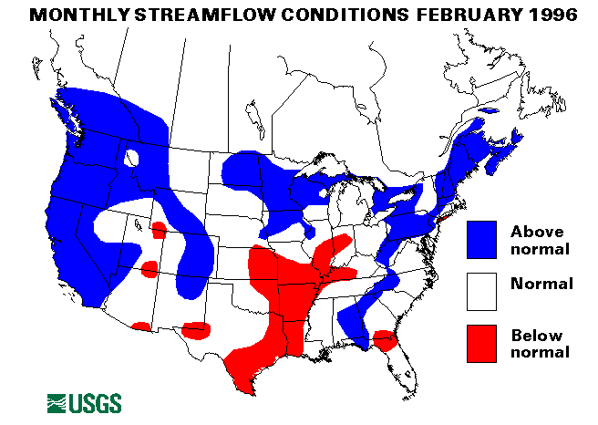
February's extreme weather conditions hit the Northwest the hardest. Heavy rains and warm temperatures on top of a substantial snowpack resulted in record flooding across Oregon and Washington and severe flooding in Idaho and Montana. Some localized flooding began between February 2 and 4 in eastern Washington and Oregon and in the Sierras of California and Nevada. Most of this flooding was due to heavy rains and resulting ice jams as flow increased. Catherine Creek near Union, Oregon, and the Umatilla River east of Pendleton, Oregon, were particularly hit hard.
Heavy rain, warm temperatures, and snowmelt hit northwestern Oregon on February 6. Flood warnings were issued for most of the coastal rivers and the tributaries to the Willamette River. Flood warnings when posted on most rivers in Washington. By February 7, the heavy rains, which continued in Washington and Oregon, spread into northern Idaho and western Montana. Ice jams aggravated the flooding in many locations. The rains and warm temperatures continued into February 8, and many stream gages recorded record high floodpeaks. These stations included the Mary's River at Philomath, Oregon, the Mollala River near Canby, Oregon, Johnson Creek at Syracuse, Oregon, the Cowlitz River at Randle, Castle Rock, and Kelso, Washington, the Chehalis River at Centralia and Grand Mound, Washington, the Nisqually River near National, Washington, the Skookumchuck River near Bucada and Centralia, Washington and the Yakima River near Parker and at Kiona, Washington. Some of the broken that were had the set records just last November. Many evacuations were necessary, and highways were closed in many locations.
From February 9 to 12, the flow in tributary streams decreased but concern about the larger rivers particularly, the Willamette in Portland, Oregon, and the lower Columbia, increased. Flood predictions were such that major flooding in downtown Portland was expected. The river crest was somewhat lower than these predictions, but major disruptions of the downtown area occurred nonetheless.
Eight index-streamflow stations recorded new maximum February monthly mean flows in Oregon, Idaho, and Washington. These were the Salmon River at White Bird, Idaho (flow 189 percent of median, peak daily flow of 14,900 cubic feet per second (ft3), on February 10), the Clearwater River at Spalding, Idaho (409 percent, peak daily flow of 137,700 ft3 on February 9), the John Day River at Service Creek, Oregon (374 percent, peak daily flow of 24,900 ft3 on February 9), the Wilson River near Tillamook, Oregon (265 percent, peak daily flow of 35,000 ft3 on February 8), the Columbia River at The Dalles, Oregon (273 percent, peak daily flow of 408,400 ft3 on February 20), the Willamette River at Salem. Oregon (260 percent, peak daily flow of 225,700 ft3 on February 9), the Skykomish River near Gold Bar, Washington (280 percent, peak daily flow of 51,200 ft3 on February 8), and the Spokane River at Spokane, Washington (387 percent, peak daily flow of 38,170, ft3 on February 12).
Other index streamflow stations that recorded new maximum February monthly mean flows were Bear Creek at Morrison, Colorado, and Rio Inabon at Real Abajo, Puerto Rico. A new minimum February monthly mean flow was reported on the Saline River near Rye, Arkansas.
From February 12 to 26, ice jam floods were common at many isolated points across the Northern United States in the thaws moved across the country from west to east. Most of this flooding was minor, although some evacuations were necessary.
Heavy rains from February 20-21 caused flash floods and mudslides in California. San Marco Pass, California, received more then 6 inches of rain on February 21. Similar heavy rains hit Kauai, Hawaii, on February 28, many reporting locations received 4 to 6 inches of rain. Highways were flooded briefly, and some mudslides were reported.
Combined flow in the three largest rivers in the lower 48 States--the St. Lawrence, the Mississippi, and the Columbia--increased 43 percent from last month to 1,237,600 ft3. This is 119 percent of the long-term February median and above normal. The flow in the Columbia River at The Dalles, Oregon, was 273 percent of median owens to the flooding in that area mentioned above. Flow in the Mississippi River at Vicksburg, Mississippi, was 106 percent of median and increased by 44 percent from January, which was indicative of the January floodwaters from the Ohio River as they movred downstream in the Mississippi.
![]() U.S. Department of the Interior |
U.S. Geological Survey
U.S. Department of the Interior |
U.S. Geological Survey
URL: https://water.usgs.gov/nwc/back_issues/feb96_cov.html
[an error occurred while processing this directive]
Page Contact Information: Water Webserver Team
Page Last Modified: Friday, 08-Jun-2007 16:37:38 EDT
URL: https://water.usgs.gov/nwc/back_issues/feb96_cov.html
Page Contact Information: NatWeb Team (GS_Help_Natweb@usgs.gov)
Page Last Modified: Friday, 08-Jun-2007 16:37:38 EDT