On December 1-2, heavy rainfall of up to 5 inches fell across eastern Pennsylvania, New Jersey and Delaware. Minor flooding was reported on the Christina River in Delaware, the Assunpink Creek in New Jersey and the Lehigh and Schuylkill Rivers, and the Neshaminy and Brandywine Creeks in Pennsylvania.
On December 7, heavy rainfall of up to 2 inches caused flash flooding across parts of New Jersey.
On December 13-14 a cold front passed through Pennsylvania, Maryland, and Delaware. Rainfall totals of 1 to 3 inches caused very widespread flash flooding. One spillway of Brighton Dam in Maryland was opened to relieve pressure on the dam. Stream and creek flooding was experienced across southern Pennsylvania.
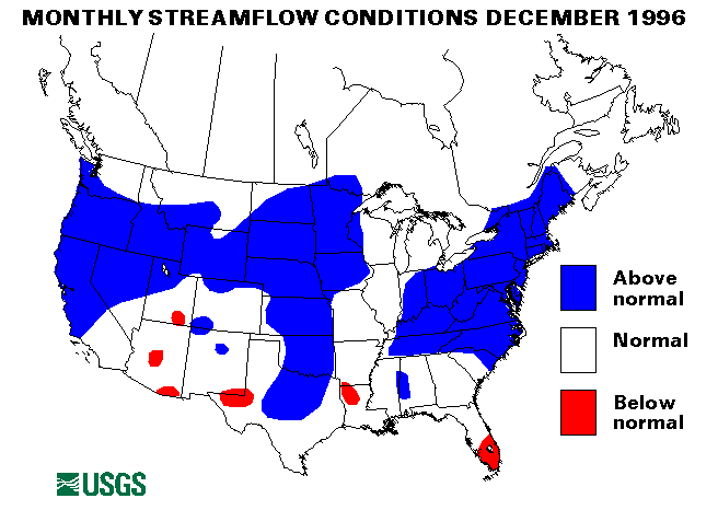
New maximum december mean monthly flows were set at six streamflow index gaging stations. These are the Potomac River near Washington, District of Columbia; the Choptank River near Greensboro, Maryland; the Seneca Creek at Dawsonville, Maryland; the South Branch Raritan River near High Bridge, New Jersey; the Delaware River at Trenton, New Jersey; and the Susquehanna River at Harrisburg, Pennsylvania.
New York and New England Region
From December 1-2 heavy rainfall fell more than 4 inches in 24-hours in many locations across New York and New England. This rainfall combined with melting snow caused moderate river flooding over a widespread area. The Connecticut River at Hartford, Connecticut crested on December 5, 2.5 feet above flood stage.
New december maximum mean monthly flows were established at four index stations. These are the Mount Hope River near Warrenville, Connecticut; the Pomperaug River at Southbury, Connecticut; the Susquehanna River at Conklin, New York; and the Mohawk River at Cohoes, New York.
Mid-South Region
On December 1 rainfall from thunderstorms of up to 4 inches caused widespread flash flooding over Alabama, Kentucky, and Tennessee. This rainfall together with rain in Illinois and Indiana caused the Ohio River to rise slightly above flood stage from Newburgh Dam, Indiana to Cairo, Illinois. The Ohio remained over flood stage through December 10. The streamflow-index station on the Ohio River at Louisville, Kentucky, was above normal for the eighth consecutive month. Flow in december averaged 260,000 cubic feet per second (ft3/s), 201 percent of the long-term median. Kentucky was hit with some localized flash flooding on December 24 due to rainfall of 1.5 to 2 inches/novernight.
Northwest Region
Up to 4 inches of rain on top of snow produced flooding conditions in southwest Oregon on December 5. Minor flooding was experienced on smaller creeks and rivers.
Another storm hit the Northwest on december 6-8. Rainfall amounts up to 7 inches were reported along the south Oregon coast.
Yet another storm dropped up to 4 inches of rain in Oregon on December 26. In combination with mountain snowmelt, most rivers in coastal Oregon saw sharp rises.
A series of Pacific storms moved inland into Washington, Oregon, and northern California from december 27 through the end of the year. These storms caused extensive flooding in Washington, Idaho, Oregon, Nevada and California. Further information and details of the flooding in Washington and Oregon are available on the districts' web pages.
Southwest Region
Northern California was hit by heavy rainfall over the weekend of December 6-8. More than 5 inches of rain was reported in Del Norte County. Streams rose to bankfull stages and a few mudslides were reported. The next storm hit northern and central California on December 10. Up to 7 inches of rain fell, and already saturated ground causing very widespread small stream flooding and mudslides.
Another Pacific storm soaked the central California coast and mountains with up to 5 inches of rain from December 21-23. Monterey, California recorded 2.96 inches in 24 hours on december 21. Significant runoff filled creeks and streams throughout the northern San Joaquin Valley and in the Sierra Nevada foothills.
The next series of Pacific storms hit California and Nevada from december 27 through the end of the year. Extremely heavy rainfall and melting snow caused record floods on the Carson and Truckee Rivers in Nevada. The Reno, Nevada, area was particularly hard hit. In California, a record peak was exceeded on the Cosumnes River at Michigan Bar, California. Flooding was also experienced on the Napa and Russian Rivers. Further information and details of the flooding in Nevada and California are available on the districts' web pages.
A new December maximum mean monthly flow was established for the index station on the Smith River near Crescent City, California. The mean flow was 21,610 cubic feet per second (ft3/s), which was 306 percent of the long-term median.
Eastern Great Lake Region
Many parts of Indian and Ohio were hit with heavy rainfall on December 11. Rainfall totaled up to 2.5 inches. Many roads were underwater, especially from small stream flooding in Ohio.
Indiana reported 1 to 2 inches of rain, along with snowmelt and wet soils, caused widespread flooding along river lowlands from December 24-27. Agricultural areas and roads along the rivers were most affected. The Wabash River crested from 2 to 7 feet above flood stage.
Southern Mid-Continent Region
Gillespie County, Texas, reported 5.35 inches of rain on December 14 with most of that rain falling in 30 minutes. Fredericksburg, Texas, experienced widespread street flooding.
On December 27-29, heavy thunderstorms dropped up to 5 inches of rain on isolated parts of Louisiana causing some flash flooding problems. A rainfall of 3 to 4 inches near Chireno, texas, on December 29 caused the Attoyac Bayou to exceed flood stage.
On december 30, Wharton County, Texas, received 3 to 4 inches of rainfall in 6 hours with rates up to 2 inches per hour. Localized flash flooding was reported.
Atlantic Southeast Region
The streamflow-index gaging station on the Meherrin River near Lawrenceville, Virginia set a new December maximum mean monthly flow with 1,315 cubic feet per second (ft3/s), 297 percent of the long-term (1961-90) median for December.
Northern Mid-Continent Region
A new December maximum mean monthly flow was established at the Nishnobotna river above Hamburg, Iowa, index station. The index gaging station on the Elkhorn River at Waterloo, nebraska, has been above-normal for eight consecutive months.
Intermountain West Region
A new December maximum mean monthly flow was established at the North Platte River above Seminoe Reservoir near Sinclair, Wyoming. The flow was 143 percent of median at 505 cubic feet per second (ft3/s).
Alaska
Streamflow index stations in Alaska reported normal flows except for the Kenai River at Cooper Landing, Alaska, which was below normal with only 49 percent of December median flow.
Hawaii
All reporting streamflow-index stations in Hawaii were in the normal range of flow.
Puerto Rico
Both streamflow-index stations in Puerto rico were in the normal flow range.
Big Three Rivers
The combined flow of the three largest rivers in the lower 48 States-- The St. Lawrence, the Mississippi, and the Columbia--increased 25 percent from last month to 1,265,000 cubic feet per second (ft3/s. This flow is 137 percent of the long-term median and in the normal range. The Mississippi River at Vicksburg, Mississippi, flow increased 36 percent from November and was 153 percent of median. The Columbia river at the Dalles, oregon, increased 28 percent from November and was 137 percent of median.
![]() U.S. Department of the Interior |
U.S. Geological Survey
U.S. Department of the Interior |
U.S. Geological Survey
URL: https://water.usgs.gov/nwc/back_issues/dec96_cov.html
[an error occurred while processing this directive]
Page Contact Information: Water Webserver Team
Page Last Modified: Friday, 08-Jun-2007 16:37:32 EDT
URL: https://water.usgs.gov/nwc/back_issues/dec96_cov.html
Page Contact Information: NatWeb Team (GS_Help_Natweb@usgs.gov)
Page Last Modified: Friday, 08-Jun-2007 16:37:32 EDT