On August 5, Grant county, New Mexico, received up to 3 inches of rain closing State Highway 61.
On August 10, heavy rainfall caused flooding along Cataract Creek in northern arizona. About 100 campers had to be rescued and the Havasupai Indian Reservation experienced severe flooding. An Amtrak passenger train derailed after a bridge was weakened near Kingman, Arizona. One death was attributed to flooding in Nevada. Mudslides closed roads in many parts of southern Nevada. On August 12 flash flooding killed 11 people in a slot canyon near Page, Arizona.
Heavy rain of up to 3 inches in an hour caused flash flooding in Gila, Pima, Cochise and Yavapai Counties in Arizona on August 15, On August 21, heavy rains near Tucson, Arizona, caused localized flooding problems. Rain fell at rates of over one inch per hour.
Albuquerque, New Mexico, reported 0.44 inches of rain in 40 minutes on August 22 which caused flooding in arroyos and low-water crossings. Parts of New Mexico received 2 to 4 inches of rain which caused flash flooding on August 23. The Tucson, Arizona, area received almost 3 inches of rain on August 24 causing street flooding. Thunderstorms again hit parts of Arizona with rainfall at rates up to 3 inches per hour on August 25.
More thunderstorms hit arizona on August 27 producing over 3 inches of rain in 3 hours in LaPaz and Yuma counties. Some homes and roads were damaged by the resultant flash floods.
Arizona and New Mexico experienced heavy thunderstorm rainfall on August 29. Rainfall up to 3 to 5 inches at some places was reported. Flash flooding along the Canadian River near Logan, New Mexico, was especially severe.
Intermountain West Region
Monsoonal thunderstorms dropped excessive rainfall on parts of Colorado
from August 1-4. Rainfall rates of 2.5 inches per hour were reported in
Weld County on both August 1 and 2. Hillrose, Colorado received 3 inches
of rain in less than one hour on August 4.
Wayne County, Utah, experienced some flash flooding on August 4 when 1.2 inches of rain was recorded in 20 minutes near Torrey, Utah. On August 5, roads were washed out near Vilas, Baca County, Colorado, following up to 4 inches of rain.
On August 9, heavy thunderstorms caused flooding and mudslides in southern Utah. U.S. Route 89 was closed at several places north of Marysvale, Utah.
Small streams flooded after 2-2.5 inches of rain fell in one hour in El Paso and Pueblo Counties, Colorado, on August 20.
On August 22, heavy thunderstorms dropped 3 inches of rain in Pocatello, Idaho causing flooding, mudflows, and washing out a bridge. 3 inches of rain near Kingston, Utah, caused debris flows and closed State Highway 62.
On August 26, heavy rains hit Loa and Bicknell, Utah, with 3 inches of rain in 2 hours washing out some roads and flooding others. Washington County, Colorado, had rains up to 4 inches closing highways due to the flash flooding.
Four inches of rain fell in 2 hours in Elbert and Lincoln Counties in Colorado on August 28.
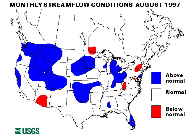
Four streamflow index stations in Idaho and Montana have been above-normal for at least 8 consecutive months. The Snake River at Weiser, Idaho, and the Yellowstone River at Billings, Montana, set new maximum August mean monthly flows at 144 percent and 185 percent of median, respectively. These two stations have been above normal for 9 consecutive months. The Clearwater River at Spalding, Idaho, has been above normal for the last 8 months and the Yellowstone River at Corwin Springs, Montana, has been above normal for 10 months.
Western Great Lakes Region
On August 2, St. Cloud, Minnesota, experienced street flooding after more
than 4 inches of rain fell in the area from severe thunderstorms.
On August 16, 4 to 5 inches of rain caused flooding in the metropolitan Chicago area.
Drought conditions over the corn belt area eased somewhat in August. Peoria, Illinois, received only 2.85 inches of rain in the period June 1 to August 9, only 31 percent of normal.
A new maximum August monthly mean flow was established at the streamflow index station on the Crow River at Rockford, Minnesota. Flow was 1438 percent of the long-term median.
Mid-Continent North Region
The Missouri River at Williston, North Dakota, was above flood stage
during the entire month of August due to upstream reservoir releases.
Other Missouri River stations were very near flood stage.
Kearny County, Kansas, received from 6 to 10 inches of rain on August 6. Roads were flooded and one bridge washed out.
Parts of Iowa were hit with 4-6 inches of rain on August 16-17. Street flooding was reported in Albia and Corydon, Iowa. Mad Creek in Muscatine County, Iowa, reported sharp rises.
Rooks County, Kansas, received over 3 inches of rain on August 21 on already saturated soils resulting in widespread small stream flooding.
Mid-Continent South Region
On August 7, Anderson County, Texas, received 5-7 inches of rain causing
flash flooding problems. More heavy rainfall across Texas, Arkansas, and
Louisiana caused flash flooding from August 8-10. Anhalt, Texas, received
6 inches of rain on August 8. Evacuations were necessary in Nacogdoches,
Texas, on August 9 after 6-7 inches of rain. Panola and Rusk Counties,
Texas, also received 4-7 inches of rain on August 9. Soto Parish,
Louisiana, had storms totalling up to 12 inches on August 8-9 causing
severe flash flooding. Parts of Union county, Arkansas, had rain fall at
rates of 3 inches per hour on August 10. Flooding near Chireno, Texas,
along Attoyac Bayou was 11 feet above flood stage.
Torrential rains up to 7 inches hit parts of Oklahoma and Texas on August 18 causing localized flooding problems. Tulsa, Oklahoma, was particularly hard hit. Houton, Missouri, was hit with 5.5 inches of rain on August 19. On August 20, Abilene, Texas, received 1.5 inches in less than 45 minutes causing severe street flooding. Concordia Parish, Louisiana, received 4-5 inches of rain in 3 hours which caused rapid rises on smaller creeks.
Heavy rains in Texas and Louisiana caused flash flooding in localized areas on August 22-23. Rainfall rates of up to 3 inches per hour were reported in Calcasieu Parish, Louisiana, and Harris County, Texas. Many roads were flooded in these areas.
Cooper, Morgan, and Pettis Counties in Missouri received up to 7 inches of rain on August 25. Creeks were over flood stage and highways were closed.
Howell and Morgan Counties in Missouri were again hit by heavy rain on August 31. 4 to 5 inches fell from nearly stationary thunderstorms.
Drought conditions persisted across south Texas. Corpus Christi, Texas, totaled only 0.34 inches of rain from June 19 to August 23. San Antonio, Texas received only 0.62 inches of rain for August.
The streamflow index station on the Washita River near Dickson, Oklahoma, has been above-normal flow for eight consecutive months.
Southeast Atlantic Region
Heavy rainfall from thunderstorms with rates up to 3 inches per hour hit
DeSoto, Charlotte and Lee Counties in Florida on August 17.
On August 21, a stationary thunderstorm dropped heavy rainfall of up to 2 inches per hour north of Wilmington, North Carolina, Localized flash flooding resulted.
Clearwater, Florida, received up to 4 inches of rain on August 22 causing widespread street flooding.
Wallace and Dunbar, South Carolina, reported up to 6 inches of rain on August 30.
Columbia, South Carolina, received only 0.22 inches of rain in August, the lowest rainfall on record.
Eastern Great Lakes Region
A storm dropped 4 inches of rain in 2 hours in the Three Rivers,
Michigan, area on August 16 causing flash flooding.
Scioto County, Ohio, received 3 inches of rain in an hour on August 27 causing rapid rises in small streams and creeks.
Mid-Atlantic Region
Heavy downpours from thunderstorms hit Atlantic City, New Jersey and
caused very severe urban flooding across southern New Jersey. 10.36
inches of rain fell in 3 hours on August 20-21 with a storm total of over
13 inches at the Atlantic City Airport.
Drought conditions eased somewhat in August throughout the region but Wilmington, Delaware, reported only 15.29 inches of yearly rainfall through August 17 which was only 58 percent of normal.
New York and New England Region
On August 29, slow moving thunderstorms dropped up to 3 inches of rain in
parts of Connecticut and Rhode Island. Small streams, streets and
basements were flooded.
Northwest Region
The three streamflow index stations in Washington, the Chehalis River
near Grand Mound, Washington, Skykomish River near Gold Bar, Washington,
and Spokane River at Spokane, Washington, have all been above normal for
the last 6 months.
Alaska
Two streamflow index stations in Alaska were below normal flow in August.
The Kenai River at Cooper Landing, Alaska, was 87 percent of median. The
Chena River at Fairbanks, Alaska, was 57 percent of median. The tenana
River at Nenana, Alaska, was above normal at 130 percent of long-term
August median.
Hawaii
The three reporting streamflow index stations in Hawaii were at normal
flows.
Puerto Rico
The streamflow index station on the Rio Grande De Manati at Highway 2
near Manati, Puerto Rico, was above normal with 138 percent of median
flow.
Big Three Rivers
The combined flow of the three largest rivers in the lower 48 states --
The St. Lawrence, the Mississippi, and the Columbia -- is not currently
available.
![]() U.S. Department of the Interior |
U.S. Geological Survey
U.S. Department of the Interior |
U.S. Geological Survey
URL: https://water.usgs.gov/nwc/back_issues/aug97_cov.html
[an error occurred while processing this directive]
Page Contact Information: Water Webserver Team
Page Last Modified: Friday, 08-Jun-2007 16:37:20 EDT
URL: https://water.usgs.gov/nwc/back_issues/aug97_cov.html
Page Contact Information: NatWeb Team (GS_Help_Natweb@usgs.gov)
Page Last Modified: Friday, 08-Jun-2007 16:37:20 EDT