Water Resources of the United States
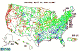
Retrieval Interface for Digital Chart of the World (DCW), Conterminous U.S.This is a collection of Digital Chart of the World files processed from CD-ROM in Vector Product Format into ARC/INFO workspaces for the conterminous U.S. This information is provided as a network service and a demonstration of image map capabilities for service of spatial data using the World Wide Web and its clients. This information is no longer available at this site. Click on a map tile (defined by blue or red outline) to retrieve DCW data in ARC/INFO workspace format. Created by Doug Nebert, USGS 8/30/94 <ddnebert@usgs.gov> Modified 3/13/95 for service under NSDI |
![]() U.S. Department of the Interior |
U.S. Geological Survey
U.S. Department of the Interior |
U.S. Geological Survey
URL: https://water.usgs.gov/dcw
[an error occurred while processing this directive]
Page Contact Information: (none)
Page Last Modified: Monday, 05-Dec-2016 11:22:59 EST
URL: https://water.usgs.gov/dcw
Page Contact Information: NatWeb Team (GS_Help_Natweb@usgs.gov)
Page Last Modified: Monday, 05-Dec-2016 11:22:59 EST