Generalized boundaries of the National Water-Quality Assessment (NAWQA) Study-Unit Investigations in the conterminous United States 1991-2001

Dates

Release Date
2006-01-31
Publication Date

Citation

Hitt, K.J., 2006, Generalized boundaries of the National Water-Quality Assessment (NAWQA) Study-Unit Investigations in the conterminous United States 1991-2001: U.S. Geological Survey data release, https://doi.org/10.5066/P9WUFPPL.

Summary

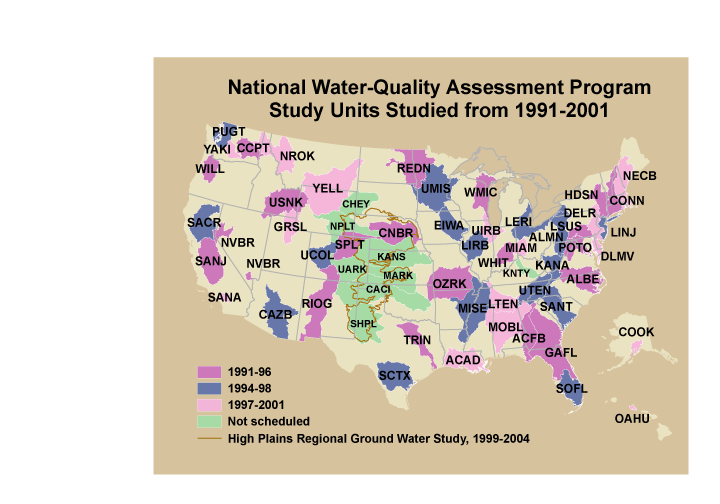
These data were released prior to the October 1, 2016 effective date for the USGS’s policy dictating the review, approval, and release of scientific data as referenced in USGS Survey Manual Chapter 502.8 Fundamental Science Practices: Review and Approval of Scientific Data for Release. This is a GENERALIZED version of the boundaries and codes used for the U.S. Geological Survey's National Water-Quality Assessment (NAWQA) Program Study-Unit investigations in the conterminous United States, excluding the High Plains Regional Ground-Water Study. The data set represents the areas studied during the first decade of the NAWQA Program, from 1991-2001 ("cycle 1"). The coverage is intended only for drawing ILLUSTRATIONS, NOT for spatial analysis. [...]

Contacts

Attached Files

Click on title to download individual files attached to this item.

nawqagencyc1_shp.zip 249.81 KB application/zip
nawqagencyc1.e00.gz 200.97 KB application/x-gzip
nawqagencyc1.tar.gz 249.95 KB application/x-gzip

Purpose

This coverage is used to DISPLAY the location of NAWQA study units at the national scale in illustrations that do not require high resolution detail. The lower resolution clears up the linework along the coastline and speeds up display. This coverage is NOT to be used for spatial analysis.
This is an image of a national map showing the cycle 1 NAWQA Study Unit boundaries.

Map

Communities

  • Model Data Management Function (MDMF)

Tags

Provenance

These data were originally released on the Water Mission Area National Spatial Data Infrastructure Node and were migrated to sciencebase.gov in 2023. These data were released prior to the October 1, 2016 effective date for the USGS's policy dictating the review, approval, and release of scientific data as referenced in USGS Survey Manual Chapter 502.8 Fundamental Science Practices: Review and Approval of Scientific Data for Release.
Additional Information

Identifiers

Type Scheme Key
DOI https://www.sciencebase.gov/vocab/category/item/identifier doi:10.5066/P9WUFPPL

Item Actions

View Item as ...

Save Item as ...

View Item...