|
|
A New Evaluation of the USGS Streamgaging Network--A Report to Congress
|
USGS streamgaging information serves many agencies: "The USGS in its' governmental role, integrates multiple funding sources to operate a data network that produces much more than if the network were funded and operated by many separate entities....The unbiased and consistent manner in which the data are collected is extremely important to activities such as diversion accounting between states and regions, settling multistate water disputes, analysis of long term trends in stream flow, etc." [Russell L. Fuhrman, Major General, U.S. Army, Director of Civil Works, written comm., 1996] "The U.S. Geological Survey stream gaging network is vital to the National Weather Service's river forecast and warning program and the goal to reduce flood damages and loss of life. Without the data from this network, this nation would experience increased losses from floods of both life and property" [Elbert W. Friday, Jr., Assistant Administrator for Weather Services, National Weather Service, written commun., January 19, 1995]
|
In parallel with the growing needs for streamflow information for water-supply planning and design was a need for information about floods. Devastating floods such as the Flood of 1913 in the Miami River Valley of Ohio, the Mississippi River Flood of 1927, and a series of massive floods in the eastern United States during the 1930's increased the awareness of the need for flood hazard information and spurred the Federal Government into action with programs to prevent or mitigate the impacts of floods, including the building of flood-control dams, levees, and flood walls. The management of economic activities within flood-prone areas became an important part of flood-damage mitigation, and the National Flood Insurance Act of 1968 created the National Flood Insurance Program.
Recently, especially since the passage of the Endangered Species Act in 1973, streamflow records have been used to evaluate the riverine and riparian habitat and conditions needed to maintain or enhance populations of birds, fish, and other organisms that depend on those rivers. These analyses of flow conditions are used to set instream-flow requirements. Scientists and citizens also have become more conscious of the potential for human activity to change the regional and even the global environment. A baseline national network of streamgaging stations provides an initial measure for detecting changes in the environment that will affect future generations (Cleaves, 1998).
Larger image is 199K, GIF Format |
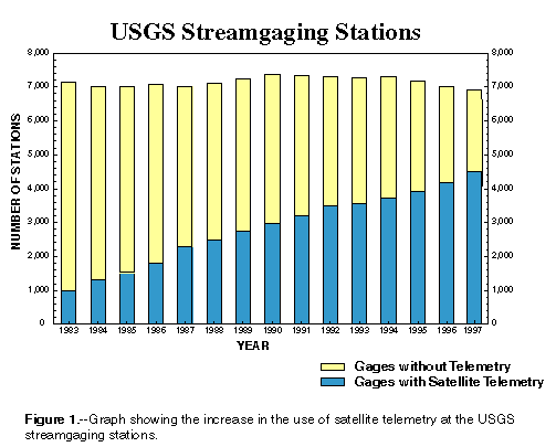
| Figure 1.–Graph showing the increase in the use of satellite telemetry at the USGS streamgaging stations. [D] |
One of the most important current users of real-time streamflow data is the National Weather Service (NWS), of the National Oceanic and Atmospheric Administration (NOAA). The NWS has responsibility to make the streamflow forecasts for the Nation's rivers; they use weather conditions and streamflow data to forecast water-level and streamflow for more than 4,000 locations along the Nation's rivers, lakes, and reservoirs.
|
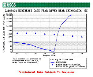
| Figure 2.–Real-time hydrograph, or plot of streamflow vs. time, served on the World Wide Web shortly after the passage of Hurricane Bonnie in August 1998. Each month, USGS provides more than 250,000 plots like this via the internet to users in government and the private sector. [D] |
A recent development in the use of streamflow data is the advent of the internet as a means of disseminating current streamflow data to a wide range of interested users (fig. 2). Presently, there are about 4,000 streamgaging stations for which near real-time data can be rapidly and freely obtained from USGS web-servers by anyone with internet access.
| Contents |
| Introduction | Purpose | Evaluation | Funding |
| Modernization | Future | Conclusions | References |
| USGS Home Page | USGS Water Resources |
U.S. Department of the Interior, U.S. Geological Survey