Water Resources of the United States
The following documentation was taken from:
U.S. Geological Survey Water-Resources Investigations Report 94-4002:
Nationwide summary of U.S. Geological Survey regional regression equations for
estimating magnitude and frequency of floods for ungaged sites, 1993
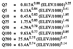
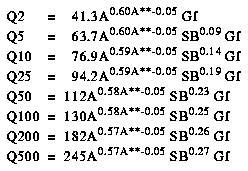
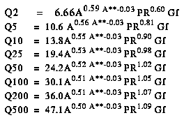
Wyoming is divided into three hydrologic regions (fig. 1). The regression equations developed for these regions are for estimating peak discharges (QT) having recurrence intervals T that range from 2 to 500 years. The explanatory basin variables used in the equations are contributing drainage area (A), in square miles; mean basin elevation (ELEV) in feet; mean annual precipitation (PR), in inches (fig. 2); and basin slope (Sb), in feet per mile. In the Plains and High Desert regions, a geographic factor (Gf) (fig. 3) is used. The constants of ELEV is divided by 1000 in the computer application of the equations. The user should enter the actual value for ELEV. The variables A, E, and Sb can be measured from topographic maps; the variables PR and Gf are shown in figures 2 and 3, respectively. The regression equations were developed from peak-discharge records available as of December 1986 at 361 stations. The equations are applicable only to natural-flow streams, and the regional average standard errors of estimate of the regression equations range from 50 to 75 percent. The report by Lowham (1988) includes procedures for estimating flood characteristics from channel geometry as well as ones for estimating mean annual and mean monthly flows by various methods. Also included in the report are flood-frequency characteristics, basin characteristics, and channel widths at stations used in the analysis.
Topographic maps, the hydrologic regions map (fig. 1), the mean annual precipitation map (fig. 2), the geographic factors map (fig. 3), and the following equations are used to estimate the needed peak discharges QT, in cubic feet per second, having selected recurrence intervals T.
Lowham, H.W., 1988, Streamflows in Wyoming: U.S. Geological Survey Water-Resources Investigations Report 88-4045, 78 p.

Figure 1. Flood-frequency region map for Wyoming. (PostScript file of Figure 1.)

Figure 2. Mean annual precipitation in Wyoming. (PostScript file of Figure 2.)

Figure 3. Geographic factors in Wyoming. (PostScript file of Figure 3.)
Accessibility FOIA Privacy Policies and Notices
![]() U.S. Department of the Interior | U.S. Geological Survey
U.S. Department of the Interior | U.S. Geological Survey
URL: https://water.usgs.gov/software/NFF/manual/wy/
[an error occurred while processing this directive]
Page Contact Information: pacampbe@usgs.gov
Page Last Modified: Thursday, 06-Mar-2014 09:35:52 EST
