Water Resources of the United States
The following documentation was taken from:
U.S. Geological Survey Water-Resources Investigations Report 94-4002:
Nationwide summary of U.S. Geological Survey regional regression equations for
estimating magnitude and frequency of floods for ungaged sites, 1993
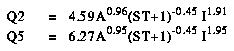
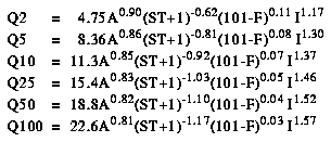
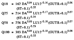
Western Oregon is divided into four hydrologic regions (fig. 1). The regression equations developed for these regions are for estimating peak discharges (QT) having recurrence intervals T that range from 2 to 100 years. The explanatory basin variables used in the equations are drainage area (A), in square miles; percentage of basin area in lakes or ponds (ST); precipitation (I), in inches, defined as the annual maximum 24-hour rainfall with a recurrence interval of 2 years (fig. 2); and forest cover (F), the percentage of the drainage area covered by forest as indicated on recent topographic maps. The constant 1 is added to ST in the computer application of the regression equations. The user should enter the actual value of ST. The precipitation variable can be obtained from figure 2, taken from NOAA Atlas 2 for Oregon (Miller and others, 1973); other variables can be measured from topographic maps. The regression equations were developed from peak-discharge records for 230 stations in Oregon and 9 in adjacent States and are applicable to all streams whose flows from 90 percent or more of the drainage area are uncontrolled. The standard errors of estimate of the regression equations by region range from 34 to 60 percent. The report by Harris and others (1979) includes maximum discharges and flood characteristics at gaging stations used in the analysis.
Topographic maps, the hydrologic regions map (fig. 1), the 2-year 24-hour precipitation map (fig. 2), and the following equations are used to estimate the needed peak discharges QT, in cubic feet per second, having selected recurrence intervals T.
Harris, D.D., Hubbard, L.L., and Hubbard, L.E., 1979, Magnitude and frequency of floods in western Oregon: U.S. Geological Survey Open-File Report 79-553, 35 p.
Miller, J.F., Frederick, R.H., and Tracey, R.J., 1973, Precipitation-frequency atlas of the western United States: NOAA Atlas 2 Volume IV- Oregon, U.S. Department of Commerce, National Oceanic and Atmospheric Administration, National Weather Service, Silver Spring, MD.
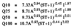
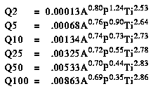
Eastern Oregon is divided into four hydrologic regions (fig. 1). The regression equations developed for these regions are for estimating peak discharges (QT) having recurrence intervals ranging from 2 to 100 years. The explanatory basin characteristics used in the equations are drainage area (A), in square miles; percentage of drainage area covered by forest (F) as shown on recent topographic maps; main channel length (L), in miles; a temperature index (Ti), which is the mean minimum January air temperature, in degrees Fahrenheit (fig. 3); and mean annual precipitation (P), in inches (fig. 4). The constant 1 is added to F in the computer application of the regression equations. The user should enter the actual value of F. The variable Ti can be obtained from figure 3, modified from Sternes (1960); P can be obtained from figure 4, modified from U.S. Weather Bureau (1964); and the other variables can be measured from topographic maps. The equations were developed from peak-discharge records available as of 1979 for 148 stations in Oregon and 14 stations in adjacent States. The equations are applicable to ungaged streams whose flow from more than 90 percent of the drainage area is unregulated. The average standard errors of estimate, by region, range from 45 to 51 percent. The report by Harris and Hubbard (1983) includes basin characteristics, flood characteristics, and maximum floods at gaging stations used in the analysis.
Topographic maps, the hydrologic regions map (fig. 1), the minimum January temperature map (fig. 3), the mean annual precipitation map (fig. 4), and the following equations are used to estimate the needed peak discharges QT, in cubic feet per second, having selected recurrence intervals T.

Harris, D.D., and Hubbard, L.E., 1983, Magnitude and frequency of floods in eastern Oregon: U.S. Geological Survey Water-Resources Investigations Report 824078, 39 p.
Sternes, G.L., 1960, Climates of the States, Oregon, in Climatography of the United States: U.S. Weather Bureau, no. 60-35, p. 17.
U.S. Weather Bureau, 1964, Mean annual precipitation, 1930-57, State of Oregon: U.S. Soil Conservation Service map m-4161, Portland, Oregon.
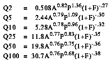
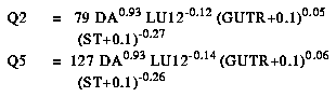
The regression equations developed for the Portland area are for estimating urban peak discharges (QT) having recurrence intervals T that range from 2 to 100 years. The explanatory basin variables used in the equations are drainage area (DA), in square miles; a land-use index (LU12); length of street gutters, in miles per square mile (GUTR); and storage (ST), the area where water can be stored during a storm event as a percentage of the total drainage area. The variables DA and ST can be measured from topographic maps, but land-use inventory maps are needed to estimate LU12. Information on gutter installation must be obtained locally. The equations were developed from peak-discharge records at 25 gaged sites, derived by synthesizing discharge from historical rainfall data. The average standard error of estimate of the regression equations is about 23 percent.
Topographic and land-use maps, information on gutter installation and the following equations are used to estimate the needed peak discharges QT, in cubic feet per second, having selected recurrence intervals T.
Laenen, A., 1980, Storm runoff as related to urbanization in the Portland, Oregon-Vancouver, Washington area: U.S. Geological Survey Open-File Report 80-689, 71 p.
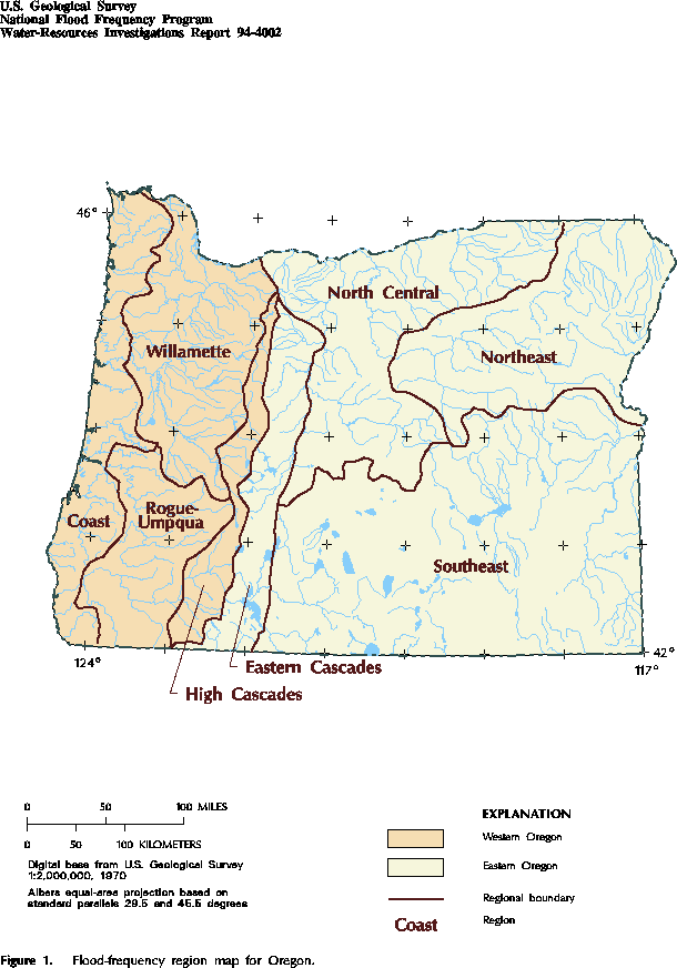
Figure 1. Flood-frequency region map for Oregon. (PostScript file of Figure 1.)
Figure 2. The 2-year 24-hour rainfall in western Oregon. (PostScript file of Figure 2.)

Figure 3. Mean daily minimum January temperature in eastern Oregon. (PostScript file of Figure 3.)
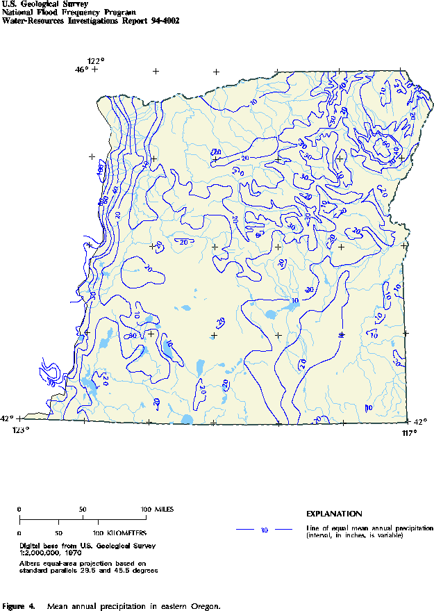
Figure 4. Mean annual precipitation in eastern Oregon. (PostScript file of Figure 4.)
Accessibility FOIA Privacy Policies and Notices
![]() U.S. Department of the Interior | U.S. Geological Survey
U.S. Department of the Interior | U.S. Geological Survey
URL: https://water.usgs.gov/software/NFF/manual/or/
[an error occurred while processing this directive]
Page Contact Information: pacampbe@usgs.gov
Page Last Modified: Thursday, 06-Mar-2014 09:35:51 EST
