Water Resources of the United States
The following documentation was taken from:
U.S. Geological Survey Water-Resources Investigations Report 94-4002:
Nationwide summary of U.S. Geological Survey regional regression equations for
estimating magnitude and frequency of floods for ungaged sites, 1993
Montana is divided into eight hydrologic regions (fig. 1). The regression equations developed for these regions are for estimating peak discharges (QT) having recurrence intervals T that range from 2 to 500 years. The explanatory basin variables used in the equations are drainage area (A), in square miles; mean annual precipitation (P), in inches; basin high elevation index (HE+10), which is the percentage of the total basin area above 6,000 feet, plus 10; and mean basin elevation (E), in feet, divided by 1000 (E/1000). The constant 10 is added to HE and E is divided by 1000 in the computer application of the regression equation. The user should enter the actual values of HE and E. The variable P is taken from a map developed by the U.S. Soil Conservation Service (1980). The other variables can be measured from topographic maps. The regression equations were developed from peak-discharge records available as of 1988 for 476 stations in Montana and 46 stations in adjacent states and Canada. The regression equations apply to unregulated streams having a drainage area ranging from 0.04 to 2,554 square miles, but are not valid where unique topographic or geologic features affect floods. The standard errors of prediction of the equations range from 22 to 128 percent. The report by Omang (1992) includes graphs of flood characteristics along seven major streams, and a table showing basin and flood characteristics and maximum floods of record at gaging stations.
Topographic maps, the hydrologic regions map (fig. 1), the mean annual precipitation map in U.S. Soil Conservation Service (1980), and the following equations are used to estimate the needed peak discharges QT, in cubic feet per second, having selected recurrence intervals T.
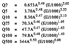
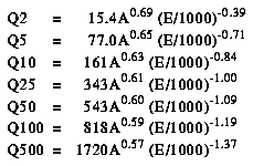
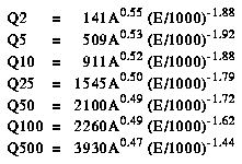
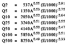
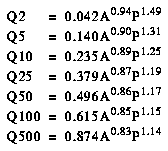

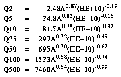
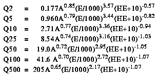
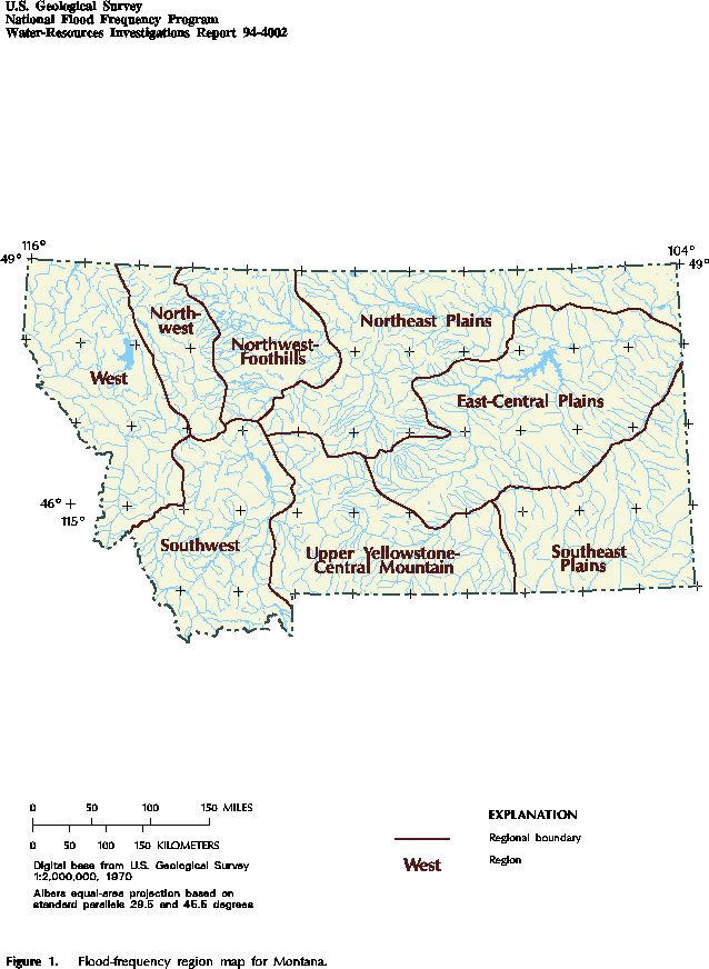
Figure 1. Flood-frequency region map for Montana. (PostScript file of Figure 1.)
![]() U.S. Department of the Interior |
U.S. Geological Survey
U.S. Department of the Interior |
U.S. Geological Survey
URL: https://water.usgs.gov/software/NFF/manual/mt/
[an error occurred while processing this directive]
Page Contact Information: pacampbe@usgs.gov
Page Last Modified: Thursday, 06-Mar-2014 09:35:51 EST
URL: https://water.usgs.gov/software/NFF/manual/mt/
Page Contact Information: NatWeb Team (GS_Help_Natweb@usgs.gov)
Page Last Modified: Thursday, 06-Mar-2014 09:35:51 EST
