Water Resources of the United States
The following documentation was taken from:
U.S. Geological Survey Water-Resources Investigations Report 94-4002:
Nationwide summary of U.S. Geological Survey regional regression equations for
estimating magnitude and frequency of floods for ungaged sites, 1993
California is divided into six hydrologic regions (fig. 1). The regression equations developed for these regions are for estimating peak discharges (QT) having recurrence intervals T that range from 2 to 100 years. The explanatory basin variables used in the equations are drainage area (A), in square miles; mean annual precipitation (P), in inches; and an altitude index (H), which is the average of altitudes in thousands of feet at points along the main channel at 10 percent, and 85 percent of the distances from the site to the divide. The variables A and H may be measured from topographic maps. Mean annual precipitation (P) is determined from a map in Rantz (1969). The regression equations were developed from peak-discharge records of 10 years or longer, available as of 1975, at more than 700 gaging stations throughout the State. The regression equations are applicable to unregulated streams but are not applicable to some parts of the State (see fig. 1). The standard errors of estimate for the regression equations for various recurrence intervals and regions range from 60 to over 100 percent. The report by Waananen and Crippen (1977) includes an approximate procedure for increasing a rural discharge to account for the effect of urban development. The influences of fire and other basin changes on flood magnitudes are also discussed.
Topographic maps, the hydrologic regions map (fig. 1), the mean annual precipitation from Rantz (1969), and the following equations are used to estimate the needed peak discharges QT, in cubic feet per second, having selected recurrence intervals T.
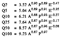
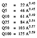
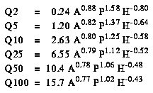
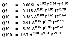
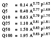
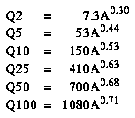
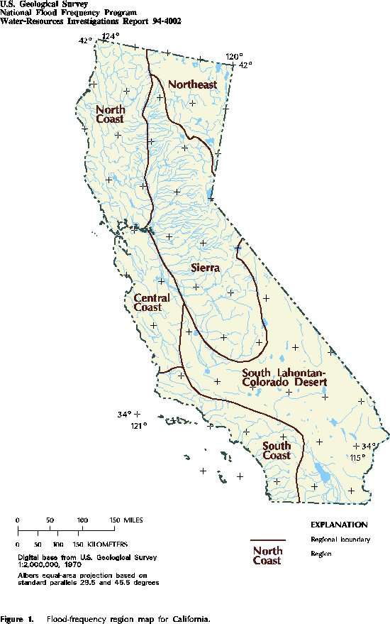
Figure 1. Flood-frequency region map for California. (PostScript file of Figure 1.)
![]() U.S. Department of the Interior |
U.S. Geological Survey
U.S. Department of the Interior |
U.S. Geological Survey
URL: https://water.usgs.gov/software/NFF/manual/ca/
[an error occurred while processing this directive]
Page Contact Information: pacampbe@usgs.gov
Page Last Modified: Thursday, 06-Mar-2014 09:35:50 EST
URL: https://water.usgs.gov/software/NFF/manual/ca/
Page Contact Information: NatWeb Team (GS_Help_Natweb@usgs.gov)
Page Last Modified: Thursday, 06-Mar-2014 09:35:50 EST
