Scientific Investigations Map 3003
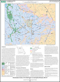
IntroductionA study of the water resources of the Springfield, Missouri, area in the 1970s determined that a cone of depression, formed by ground-water pumping, had developed in the Ozark aquifer beneath the city (Emmett and others, 1978). Continued ground-water usage in the 1970s and 1980s caused concern that ground-water resources would not be sufficient to meet the future needs of Springfield, Missouri, during periods of drought. As a result, a ground-water flow model of the Springfield area was developed by the U. S. Geological Survey (USGS) to assess the future role of ground water as a water source for the area (Imes, 1989). Results of the USGS model led to a decision by the City Utilities of Springfield to primarily rely on surface water from Stockton Lake as a source of city drinking water. Municipal and industrial ground-water usage continues in Springfield, but at lower rates than previously experienced (Jim Vandike, Missouri Department of Natural Resources, written commun., 2007). Rapid growth in the area has caused commercial, industrial, and domestic water use to increase. Population growth has been especially rapid in Nixa, Ozark, and Republic, and water use in the vicinity of these cities has grown an estimated 39 percent since 1990 (Dintelmann and others, 2006). Unlike Springfield, ground water is the primary source of water for these cities. The increased stress on the Ozark aquifer, the primary aquifer in the study area, has raised new concerns about possible further water-level declines in the areas of increased ground-water use. Although there continues to be new development in the Ozark aquifer, since 1987 no new water-supply wells that produce water from the Springfield Plateau aquifer have been allowed to be constructed in most of Greene and northern Christian counties (Jim Vandike, Missouri Department of Natural Resources, written commun., 2007). There is concern that if the potentiometric surface of the Ozark aquifer continues to decline, increased leakage of contaminants into the Ozark aquifer from the overlying Springfield Plateau aquifer could occur (Jim Vandike, Missouri Department of Natural Resources, written commun., 2007). To address this concern, the USGS, in cooperation with Greene County, Missouri, the U.S. Army Corps of Engineers, and the Missouri Department of Natural Resources, constructed a map of the potentiometric surface of the Ozark aquifer for 2006–2007. The map can be compared to previously constructed potentiometric-surface maps by Emmett and others (1978) and Imes (1989) to evaluate changes in ground-water flow directions, but the comparison is beyond the scope of this report. |
Posted February 2008
Download report (3 MB pdf) |
Richards, J.M., and Mugel, D.N., 2008, Potentiometric surface of the Ozark aquifer near Springfield, Missouri, 2006–07: U.S. Geological Survey Scientific Investigations Map 3003, 1 sheet.

![]() U.S. Department of the Interior | U.S. Geological Survey
U.S. Department of the Interior | U.S. Geological Survey
URL: http://pubsdata.usgs.gov/pubs/sim/3003/index.html
Questions or Assistance: Contact USGS
Last modified: Thursday, 01-Dec-2016 17:10:27 EST
