
This document is also available in pdf format: fs036-03.pdf (711KB).
Rapid-deployment data-collection networks were developed for wildland fire applications like the Missionary Ridge Fire. The Missionary Ridge Fire began June 9, 2002, near Durango, Colorado. An Interagency Burned Area Emergency Rehabilitation (BAER) Team arrived in Durango, Colorado, to assess the fire. At that time, the fire had burned over 70,000 acres and was still actively burning. The fire was contained on July 14, after consuming 73,400 acres. The team was charged with assessing the potential postfire effects on health and safety, and risks to property and natural resources. From this assessment, the team would prescribe treatments on Federal lands to reduce damage to the values at risk from the burned watersheds. The team found that human life was at risk early in their assessment.
The fire originated near the town of Durango and intensely burned the steep watersheds above the east side of town. From there, the fire moved in a northeasterly direction and burned areas around Vallecito and Lemon Reservoirs. Both of the reservoirs are municipal water supplies. Many homes and roads are located below burned watersheds and in the direct path of predicted flood and debris-flow areas (fig. 1). The BAER team calculated that relatively small amounts of rainfall could cause flood and debris-flow events that could damage property and threaten life. Compounding this situation was the potential for increased precipitation due to the monsoon season, which began near the end of the fire. The air-flow pattern in the monsoon season produces frequent intense thunderstorms in the southwest United States during July and August. Under burned conditions, normally inconsequential rainfall amounts can and do produce severely damaging floods. In addition, these floods frequently carry large quantities of fire debris and suspended sediments, which can approach debris-flow proportions. The combination of burned watersheds and potential monsoonal thunderstorms placed human life at immediate risk. Improving the accuracy of storm forecasting to aid in flood and debris-flow warnings was needed quickly.
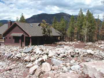 |
| Figure 1. Mudslides occurred on August 4, 2002, after precipitation fell in the burned area of the Missionary Ridge Fire. |
The critical elements in improving forecasting and warnings are real-time or near real-time precipitation and flow data for the burned areas. These data provide necessary information to calibrate (ground truth) predictive-model and Doppler-radar estimations to real conditions. The data also provide information of areal conditions to emergency management personnel and others requiring flow information, such as domestic water-system operators and reservoir managers.
Realizing the potential hazards, the BAER team submitted a request to the U.S. Forest Service (USFS) for financial support to install a satellite-telemetered rapid-deployment data-collection network and received USFS approval the same day. On that same day, the BAER team requested assistance from the U.S. Geological Survey (USGS), which operates and maintains similar types of data-collection networks for the northern Black Hills area near Rapid City, South Dakota. Within 7 days of the start of the BAER team's investigation (day 7), the network was designed and funded, and sites were cleared for installation of 12 precipitation gages. On day 8, the first gage was installed and transmitting data, and by day 17 all the gages were installed and operating. The National Weather Service (NWS) was able to use the data in flood forecasting by day 14.
The rapid-deployment networks described here are networks of precipitation or flow gages prescribed and funded under BAER authority to reduce risk to public safety and health from flooding and associated phenomena originating on public lands administered by U.S. Department of Agriculture (USDA) and U.S. Department of the Interior (USDI). Current policy allows for USDA and USDI funding network installation and up to 3 years of operation and maintenance. On the Missionary Ridge Fire, the USFS provided the funding and directed fire rehabilitation activities, including the installation of hydrologic data-collection networks. Generally funding is approved when government agencies other than USDA or USDI agree to receive, interpret, and act upon the data gathered by the network.
As indicated in table 1, there are four primary steps used in operational models for a rapid-deployment network: funding, network installation/operation, issuance of watch or warning, and emergency response. Installation and maintenance of data-collection equipment have been performed internally by the USDA and USDI land-management agencies and by the USGS and other agencies. The USGS was selected by the Missionary Ridge BAER team because the USGS has experience with this type of network, has the ability to install the equipment quickly, and has an established relationship with the NWS. The USGS installed the data-collection network, operates and maintains the network, and provides the data to the users by satellite transmissions.
| Fire name | Funding agency |
Network operation |
Watch/ warning issuance |
Emergency response |
| Missionary Ridge | USGS | USGS | NWS | La Plata County, Colorado |
| Grizzly Gulch | BLM | USGS | NWS | Lawrence County, South Dakota |
| Battle Creek | USFS | USGS | NWS | Pennington County, South Dakota |
USDA and USDI land-management agencies with BAER authority have little or no expertise in flood forecasting and no authority to issue or carry out flood warnings or evacuations. The USGS has a similar policy and will enter into an agreement to install and maintain equipment only when other agencies have agreed to provide the 24-hour monitoring and take emergency action based on the data. The NWS and La Plata County Office of Emergency Preparedness agreed to these roles for the Missionary Ridge Fire. The NWS interprets the data and formulates hazard watches and warnings as required. The Office of Emergency Preparedness provides assignment of emergency response resources and coordinates response activities. Each party continues operating in their respective mission-specific roles. Butch Knowlton, La Plata County Emergency Manager, commented, "The network has been invaluable to emergency service personnel. By monitoring the network they know when and where to effectively commit manpower and resources. Information from the network assists water-system operators in determining basins affected by runoff allowing them time to close critical intakes. Even road crews and contract personnel monitor the system for safety. We don't know how we could have handled this situation without it."
A similar operational model to the model described for the Missionary Ridge Fire has been in use for almost 7 years in the Rapid Creek drainage above Rapid City, South Dakota, and recently (2002) similar models have been used following the Grizzly Gulch and Battle Creek Fires in South Dakota (table 1). The rapid-deployment network has been effective in providing warning to residents of Deadwood, South Dakota, where mudslides have resulted from precipitation in the burned areas of the Grizzly Gulch Fire (fig. 2).
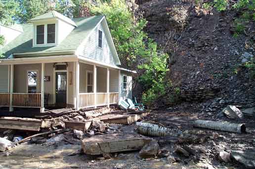 |
| Figure 2. Mudslides occurred on August 8, 2002, after precipitation fell in the burned area of the Grizzly Gulch Fire. |
Rapid-deployment data-collection networks, such as the one installed at Missionary Ridge, are comprised of a series of field sensors, GOES/DOMSAT satellite transmitters, ground-readout delivery systems, and solar-power modules.
 |
 |
 |
||
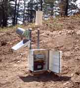
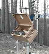
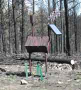
| A. Precipitation gage (instrument detail) used in burned area at Missionary Ridge Complex Fire. | B. Precipitation gage used in burned area at Grizzly Gulch Fire. | C. Precipitation gage used in burned area at Battle Creek Fire. |
Figure 3. Examples of equipment used in rapid-deployment networks in burned areas at the Missionary Ridge, Grizzly Gulch, and Battle Creek Fires.
Examples of equipment used in the satellite-telemetered early-warning networks for the Missionary Ridge, Grizzly Gulch, and Battle Creek Fires are shown in figure 3 in burned areas. The field sensors collect data for a variety of hydrologic measurements selected by the BAER team to meet specific needs. Precipitation and stream stage are the most frequently acquired measurements, but other water-quality and quantity data can be collected. The data from the sensors are processed in a field data-collection platform (DCP) and transmitted to the GOES weather satellite. The processed GOES data are transmitted for local use to ground-readout stations by way of the DOMSAT satellite. The steps involved to deploy a network of this type are as follows:
The hydrologic data-collection network developed for BAER applications is a satellite-telemetered precipitation- and stage-gage network. The precipitation-gage network is designed to record precipitation over the burned area in near-real time. Where feasible, the network is laid out in a pattern that will facilitate tracking the path of storms across the burned area, helping NWS forecasters determine storm movement. Each precipitation gage is connected to a DCP where the data are processed and logged. Under normal conditions, the DCP will accumulate data at a set sample rate (1 minute, 15 minutes, 30 minutes, etc.) and transmit the accumulated data every 4 hours to the satellite. High data-rate transmitters that are now available are programmed to transmit DCP data hourly. Threshold limits are programmed into the DCP that, when exceeded, initiate an immediate "forced-random" transmission. These forced-random transmissions are used to deliver near-real time data to the user. This allows the user to assess field information within a matter of minutes. Data collected in this manner can provide near-real time assessment of precipitation and ground-truth data for live Doppler radar. If precipitation gages are coupled with stage gages, streamflow also can be monitored. In order to meet special circumstances, additional data measurements can be collected, such as air and water temperature, pH, specific conductance, turbidity, and dissolved oxygen as specified. Data transmitted from the site to the GOES weather satellite are processed and distributed by the DOMSAT satellite to local ground-readout stations. The NWS and the USGS use separate data-collection networks, which provides redundancy for the system. Each gage is independently solar powered, making remote installations feasible. The satellite-telemetered network is uniquely suited for mountainous terrain unlike radio-based systems that require line-of-site transmission.
Based on experiences of establishing rapid-deployment networks in the aftermath of the Missionary Ridge, Grizzly Gulch, and Battle Creek Fires, a number of changes to past practices could be implemented in future situations that would standardize funding procedures, secure stocks of instrumentation, reserve satellite window assignments, and define working agreements and responsibilities.
For more information, please contact:
District Chief
U.S. Geological Survey
1608 Mt. View Road
Rapid City, SD 57702
(605)355-4560
or visit the USGS Web Site at: http://sd.water.usgs.gov
U.S. Department of the Interior
U.S. Geological Survey Fact Sheet FS-036-03
This report is available online in Portable Document Format (PDF). If you do not have the Adobe Acrobat PDF Reader, it is available for free download from Adobe Systems Incorporated.
Download the fact sheet (PDF, 711KB).
Document Accessibility: Adobe Systems Incorporated has information about PDFs and the visually impaired. This information provides tools to help make PDF files accessible. These tools convert Adobe PDF documents into HTML or ASCII text, which then can be read by a number of common screen-reading programs that synthesize text as audible speech. In addition, an accessible version of Acrobat Reader 5.0 for Windows (English only), which contains support for screen readers, is available. These tools and the accessible reader may be obtained free from Adobe at Adobe Access.
| Fact Sheet Home Page |
Environment | Hazards | Information Management |
Resources | State |
| U.S. Department of the Interior,
U.S. Geological Survey Maintainer: Fact Sheet Team Last update: 07:48:27 Fri 21 Feb 2003 Privacy Statement || Disclaimer || Accessibility URL: https://pubs.water.usgs.gov/fs03603 |
 |