U.S. Department of the Interior
US Geological Survey
USGS Fact Sheet 050-99
August 1999
This report is also available as a pdf (1 MB)
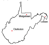
The safety, health, and economic well-being of West Virginia's citizens are important to the US Geological Survey (USGS). The USGS provides products and information to help others manage, develop, and protect the State’s natural resources. USGS centers are located in Charleston, Leetown, and Morgantown, W.Va.
The USGS Charleston office provides the information and understanding needed for wise utilization and management of the State’s water resources. Hydrologic studies throughout West Virginia describe the occurrence, availability, and physical, chemical, and biological characteristics of surface water and ground water.
The USGS Leetown Science Center, established in 1931, is the oldest Federal fishery research facility. USGS personnel conduct integrated research programs addressing the needs of aquatic resource managers and public policymakers. Examples of these research programs include the behavior of migrating fish affected by dams and barriers, control and prevention of fish diseases, development of water recycling methods to reduce energy requirements, and identification of fish populations by genetic structure.
The USGS West Virginia Cooperative Fish and Wildlife Research Unit, formed in 1986 at West Virginia University in Morgantown, focuses on the examination of environmental concerns such as the effects of timber harvesting on birds, stresses of acidic water on aquatic species, habitat requirements for fish, and the effects of gypsy moth spraying. Graduate education also is an important mission of the Unit.
These West Virginia-based centers, in coordination with national USGS programs, enable the USGS to build strong, multidisciplinary teams that can apply science for a changing world. To serve the public better, the USGS is concentrating its programs under four major themes—Hazards, Resources, Environment, and Information Management.
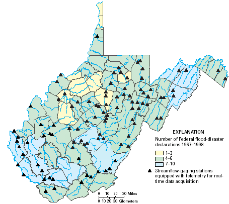
Floods are among West Virginia’s most frequent and costly natural hazards in terms of human hardship and economic loss. Federal flood disasters have been declared at least once in every county during the period 1967–98, and as many as 10 times in some counties (fig. 1). The USGS is helping to reduce flood losses in West Virginia through activities that provide flood-protection planning information and real-time warnings.
|
| Figure 1. Flood declarations and realtime streamflow-gaging stations. |
In cooperation with the West Virginia Division of Highways (DOH), the USGS is developing methods to estimate the frequency and magnitude of floods on streams. Information about the possibility of floods provides a basis for planning and proper design of structures to minimize repetitive flood impacts. Flood frequency and magnitude estimates will help DOH improve the design of roads and bridges, and will benefit the design and development of flood-resistant communities, the daily operation of dams and reservoirs, and the development of disaster-preparedness plans.
The USGS also is working with the West Virginia Office of Emergency Services, the US Army Corps of Engineers, and the National Weather Service to develop a floodwarning system to protect life and property during a flood. New streamflow-gaging stations are being built on streams, and equipment is being added to many existing stations to allow for real-time transmission of water-level data. Currently (1999) telemetry equipment is installed at 98 streamflow-gaging stations through- out West Virginia (fig. 1), 81 of which transmit data by way of satellite relay to USGS computers. These data are available on the World Wide Web at http://www-wv.er.usgs.gov/rt.html. This real-time system allows for more accurate flood forecasting, timely warnings, and vital information for flood management and disaster response.
USGS researchers at the West Virginia Cooperative Fish and Wildlife Research Unit are working with State agencies to develop a risk-based protocol for issuing fish consumption advisories in West Virginia. Sport-fish consumption advisories now in use are based on US Food and Drug Administration guidelines, but these limits were developed for consumers who purchase commercially caught fish and seafood. The continued use of these guidelines could underestimate the fish consumption of subsistence sport fishermen and their families, and could put them at risk. The new protocol will be modeled after guidelines used in the Great Lakes area to alert sport fishermen of the risk of consuming contaminated fish. West Virginians who fish in areas of contamination will be provided a guide for determining limits on the amounts of fish that can be consumed safely.
To help ensure that drinking water supplies are safe for human consumption, the USGS is working with the West Virginia Division of Environmental Protection Office of Water Resources to assess the quality of ground water from principal aquifers within the State. The USGS plans to sample water from 30 different wells (primarily public supply wells) annually during the next 5 years for analysis of a broad range of constituents including bacteria, trace metals, nutrients, common ions, volatile organic compounds, pesticides, and radon. After completion of water sampling, all available data will be analyzed to document the quality of ground water available from principal aquifers throughout the State. Additional water samples also are to be collected for analysis of chlorofluorocarbon and dissolved gas to determine the age of ground water within the aquifers in various regions of the State. The ground-water age data can be used to assess and define wellhead and source-water protection areas for public supply wells and springs.
The USGS also is assisting the West Virginia Bureau for Public Health Office of Environmental Health Services by documenting techniques to determine if groundwater quality is directly influenced by surface- water quality. The USGS also is documenting techniques for assessing the susceptibility of selected ground- and surface-water supplies to contamination, and developing techniques to determine source-water protection areas.
USGS researchers at the West Virginia Cooperative Fish and Wildlife Research Unit and West Virginia University are partners in a US Department of Agriculture project to evaluate aquaculture in the Appalachian Region. The project is intended to determine the effects of aquaculture stressors (ammonia, nitrite, dissolved oxygen, and others) on rainbow trout and to determine how these stressors affect the quality of fresh fillets and value-added products such as smoked fillets. Aquaculture production in West Virginia is small-scale because of limited water flow from coldwater springs and streams and from small farm ponds. Key constraints on aqua-culture growth in West Virginia and Appalachia include the lack of information about market potential, the costs of production and processing, variability in product quality and consistency, and risk factors associated with investing in aquaculture. The project is helping to develop marketing strategies for trout producers and processors and to increase the economic viability of trout-based aquaculture.
Since 1993, the USGS, in cooperation with the West Virginia Geological and Economic Survey, has digitally modeled the most productive coalbeds in the Appalachian Basin. Resource-assessment models offer policymakers, land managers, and the public concise, geographically referenced data about the quality and quantity of original and remaining coal resources. Six coalbeds (Pittsburgh, Upper Freeport, Lower Kittanning, Fire Clay, Pond Creek, and Pocahontas No. 3) in the Appalachian Basin are being modeled. All six coalbeds are, in part, located in West Virginia. Data for each coalbed include estimates of original and remaining resources, stratigraphic and geochemical databases, geographic information system maps of elevation, thickness of coal and overburden, areal extent, and mined areas. Ash yield, sulfur content, calorific value, and potentially hazardous geochemical constituents such as arsenic, mercury, and lead are planned for future study.
Natural gas occurs in sandstone, shale, and carbonate rocks in large continuous reservoirs that commonly contain very large in-place gas resources. These gas accumulations may be a future source of energy. The USGS studies in West Virginia are designed to determine the spatial distribution of these continuous gas accumulations, characterize the reservoirs, identify the geologic reasons for these gas accumulations, and develop methods to assess poorly defined or unrecognized continuous gas accumulations elsewhere in the United States. USGS efforts are focused on natural gas accumulations of regional dimensions.
Underpressured thermogenic gas (formed from buried organic matter by the natural heat of the earth) in low-permeability sandstone rocks is located, in part, in western West Virginia. This reservoir, which extends throughout much of the Appalachian Basin, may contain several tens of trillions of cubic feet of natural gas, much of which may be recoverable.
Coalbed methane (CBM) is becoming an increasingly important source of unconventional natural gas in West Virginia and the Nation. As part of a larger USGS investigation to increase understanding of this energy resource, existing sources of CBM in the northern and central Appalachian Basin are being evaluated. USGS efforts are intended to quantify, map, and model sources of CBM and may include desorption tests, production data, and coal stratigraphy.
Most of southern West Virginia and parts of neighboring States are located in a relatively deep foreland structural basin near the junction of the central and southern Appalachians. The basin is one of the few remaining areas of the Appalachian Plateau that has not been extensively tested for hydrocarbons even though it is near potential shale source rocks in eastern Tennessee and southwestern Virginia. A new USGS project is planned to investigate several topics to improve the assessment of potential hydrocarbon resources in the deeper, generally unexplored parts of the Central Appalachian Basin.
A cooperative study by the USGS and the West Virginia Geological and Economic Survey is developing information for the entire coal-bearing sequence of rocks in West Virginia. Development of improved methods to predict, mediate, and mitigate contaminated coal-mine drainage requires an understanding of the geochemistry of coal-bearing strata. Geological, geophysical, and geochemical logging of well cores and core holes is defining stratigraphic variations in the geochemistry of specific stratigraphic intervals and is defining those intervals that are prone to drainage problems.
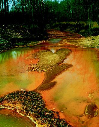
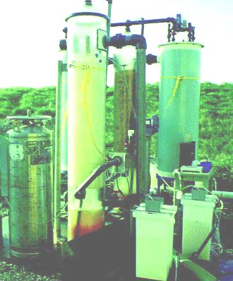
Acidic, metal-laden drainage from abandoned coal mines is common in Appalachia, and has had substantial effects on aquatic resources (fig. 2). The cost of correcting acidic mine drainage-related problems in Appalachia with currently available technology is estimated at $5–$15 billion. Research by the USGS has resulted in the development of a new treatment technique to assist in stream restoration. This new technology integrates fluidized-bed reactors with carbon- dioxide adsorption and desorption steps to circumvent problems that currently limit the effectiveness of limestone as an acid-neutralizing reagent (fig. 3). The USGS is working with the National Park Service, the Freshwater Institute, and others to field test the technology and to determine the effects of the treatment process on acid-sensitive aquatic invertebrates and fish. Studies also are planned to identify improved methods for heavy-metal separation and sludge thickening.
|
| Figure 2. Stream affected by acidic mine drainage. |
|
|
Figure 3. Apparatus developed for stream restoration. |
Since 1995, the USGS has awarded West Virginia University grants to develop geographic information system (GIS) databases for the State within the Federal Geographic Data Committee (FGDC) planning framework. The framework is a collaborative effort to create a widely available source of basic geographic data. West Virginia University will maintain a clearinghouse computer to distribute GIs datasets for West Virginia. The most recently awarded FGDC framework project, “Building the Foundation for a Fully Operational Framework for West Virginia,” will develop a users’ group for hydrography and image products and a plan for long-term database maintenance.
West Virginia University is collecting and disseminating GIs digital line graphs from USGS 1:24,000-scale topographic quadrangle maps. This effort includes data in four categories: hydrography, transportation, topography, and boundaries. Hydrography, topography, boundary, and transportation data have been completed for approximately 150 of the 450 quad- rangles in the State.
Digital orthophoto quadrangles (DOQ’s) for the southern part of the State are being produced using 1996 and 1997 leaf-off color-infrared aerial photographs through a cooperative partnership of the USGS and the West Virginia Geological and Economic Survey. A DOQ combines the image characteristics of a photograph with the scale accuracies of a map, and it can be a component in geographic information systems. The DOQ’s may be used for the Mineral Lands Mapping Program and for political, economic, and environmental planning.
The West Virginia Geological and Economic Survey cooperates with the USGS to provide an Earth Science Information Center (ESIC) as a local resource for obtaining information about the publications and products of the USGS and State agencies. The ESIC can provide information about historical maps, aerial photographs, flood-prone area maps, and thematic maps for coal and mineral resources.
|
USGS office locations
|
USGS State Representative USGS Home Page Reports and products
|
| AccessibilityFOIAPrivacyPolicies and Notices | |
 |
|