|
|
For more than 100 years, the U.S. Geological Survey (USGS) has provided the
information needed to manage the Nation's earth resources, to mitigate
natural hazards, and to understand the environment. In South Dakota, the
USGS works cooperatively with local, State, and other Federal agencies, as
well as with universities, to study earth science issues. |

|
|
Among the most popular and versatile products of the USGS are its
1:24,000-scale topographic maps (1 inch on the map represents 2,000 feet on
the ground). These maps depict the basic natural and cultural features of
the landscape, such as lakes and streams, highways and railroads,
boundaries, and geographic names. Contour lines are used to depict the
elevation and shape of terrain. South Dakota is covered by 1,552 maps at
this scale. These maps are used by scientists and managers for
engineering, land-use planning, natural-resource monitoring, and other
technical applications and have long been favorites with the general public
for outdoor uses. These maps also serve as bases for many special purpose
maps produced by other agencies, such as State, county, and local highway
maps; land-use and ownership maps; geologic maps; and recreational maps.
|
Recent technological advances, particularly in the field of geographic
information systems (GIS), have increased demand for digital map products
for South Dakota, especially of the Black Hills area. This area was
identified as having priority map data requirements by the Bureau of Land
Management, the Bureau of Reclamation, the U.S. Fish and Wildlife Service
(USFWS), the National Park Service (NPS), and other agencies. To minimize
duplication of effort, the USGS is currently producing digital map data for
more than 100 1:24,000-scale maps of the Black Hills area. The data
provide the base cartographic data needed by many Federal and State agency
users for their specific GIS and resource-management activities in the
region. The USGS has cooperative agreements to produce digital elevation
models (DEM's) and digital orthophotoquads (DOQ's) in South Dakota. DOQ's
are digitized images of aerial photographs with relief distortion removed.
In cost-sharing agreements with the NPS, the USGS is producing DOQ's for
Mount Rushmore National Memorial, Badlands National Park, Wind Cave
National Park, and Jewel Cave National Monument. |
|
|
|
The USGS also has cooperative programs to produce digital cartographic data
for the Bureau of Indian Affairs (BIA) Area Office in South Dakota. DOQ's
have been produced for the Flandreau Indian Tribe in southeastern South
Dakota, and DEM's are scheduled for several areas of the State. These data
provide a foundation for natural-resource management for the BIA and tribal
governments.
|
The USGS recently completed the digitizing of Public Land Survey System
data for the State east of the Missouri River. The USFWS' Wetland Habitat
Office uses the township, range, and section information as a base for
wetlands analysis. |
|
|
|
Data on quantity and quality of streamflow and ground water provide an
increased understanding of the water resources of South Dakota. These data
are necessary for forecasting floods and droughts, designing reservoirs and
water-supply systems, sizing highway structures, and managing water use.
The USGS began systematic collection of streamflow data in 1903 with the
establishment of 13 gaging stations in the Black Hills area. During 1996,
the USGS, in cooperation with 31 Federal, State, and local agencies, has
been operating an extensive data-collection network. The network includes
137 continuous-record gaging stations on streams and lakes, 23 crest-stage
stations, 46 precipitation stations, 27 water-quality and sediment
stations, and 7 observation wells (fig. 1).
The USGS also processes and stores water-level data for about 65 additional
wells operated by the State. Most of the basic data are published annually
in Water Resources Data--South Dakota. Selected streamflow data also are
available on the
World-Wide Web. |

(Click on image for a larger version, 50K GIF)
|
|
Figure 1. Locations where streamflow, water-quality,
sediment, and water-level data were collected by the USGS during
1996. | |
|
|
|
Geologic mapping and research by the USGS is of direct benefit to numerous
Federal, State, and local agencies. As an example, the USGS, in
cooperation with the South Dakota Geological Survey (SDGS), is compiling
and publishing a new State geologic map. |
Mapping and research benefit numerous agencies in their land-use planning
and such commercial ventures as the mining and tourism industries of the
Black Hills. Because the economic health of the northern Black Hills
depends, in large part, on the $150-million-a-year mining industry, western
South Dakota has a vested interest in a viable mining industry. The
interaction of science and technology ensures that mining in the future is
compatible with other industries and will be conducted with due regard for
private and Federal lands and the environment. Preparation of a new
geologic map of the Black Hills at a scale of 1:100,000, in cooperation
with the South Dakota School of Mines and Technology, is underway and is
intended to serve as a base for all future investigations in the Black
Hills area. Ongoing geologic research by the USGS, in cooperation with
private industry at the Homestake and the Annie Creek Mines, will
streamline exploration, improve ore-reserve estimation, improve
metallurgical techniques, and assess the future impacts of mining in the
northern Black Hills. Information from the research aids USGS hydrologists
in modeling the long-term quality of surface and ground waters in the
entire Black Hills area. Other beneficiaries include the U.S. Forest
Service for their assessments of future developments on forest lands and
Federal and State agencies for making effective and informed land-use
decisions. |
|
|
|
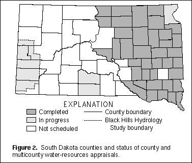
The USGS, in cooperation with the SDGS and various counties, Indian Tribes,
and Water Development Districts, has been appraising water resources in
South Dakota since 1958 (fig. 2). Typically, the studies are done on a
county-by-county basis and last 3 to 4 years; many studies have involved
multiple counties. Most county studies in the eastern part of the State
have been completed, and areal studies have recently begun in the western
part. The studies typically use extensive test-hole drilling and
observation-well installation and monitoring to determine the availability,
movement, recharge, discharge, and quality of water in glacial and bedrock
aquifers. The studies usually result in four reports, three of
which--detailed geology, major aquifers, and sand and gravel--are published
by the SDGS, and one--detailed water resources--is published by the USGS. The
reports are useful for water-resource planning by State and local agencies
and by local citizens. |

(Click on image for a larger version, 50K GIF)
|
|
Figure 2. South Dakota counties and status of county and
multicounty water-resources appraisals. |
|
|
|
|
The USGS Earth Resources Observation Systems (EROS) Data Center near Sioux
Falls is the world's largest nonmilitary repository of remotely sensed data
of the Earth's land surface. Much earth science research is based on
images from the EROS archives, which hold worldwide digital image data from
satellite-borne sensors and more than 7 million aerial mapping photographs
of the Nation. EROS distributes large quantities of digital and
photographic products to governmental and commercial users and to the
general public at the cost of reproduction.
EROS hosted the Scientific Assessment and Strategy Team (SAST), which was a
Federal response to massive flooding in the Missouri River and the
Mississippi River drainage basins that devastated crops, homes, and
businesses during 1993. The SAST effort was summarized in a report that
provides scientific advice and assistance to Federal officials responsible
for making decisions with respect to flood recovery and supplies
information regarding nonstructural and structural approaches to river
basin management. |
EROS participation as a cooperator in the Great Plains Initiative is
another example of its regional role. The Great Plains Initiative, which
was one of the results of the Western Governors Conference, is
demonstrating that economic development and ecological management can be
served by preventing the decline of wildlife species and their ecosystems.
The work involves gathering and linking data bases of the ecosystems of the
Great Plains. The EROS contribution to this cooperative interagency effort
is to provide earth science information and to develop data-transfer
technologies.
South Dakota also benefits from EROS data collection, research, and
dissemination of information at continental and global scales. Because of
repeated coverage of large areas, satellite sensors can detect changes on
the Earth's surface. For example, EROS scientists use data from these
sensors to construct timely maps that show vegetation condition or
"greenness" information (fig. 3), and provide
these data to the South Dakota Department of Agriculture as part of the
Grassland Fire Danger Assessment Project. This statewide information is
updated on a weekly basis. Greenness information also is sent to the
National Weather Service in Sioux Falls where it is combined with daily
weather information to forecast fire danger conditions. Whenever severe
conditions exist, current information is provided to emergency monitoring
centers and the news media for broadcast to the public. Numerous
global-scale applications, such as
showing probable migration routes of locust hordes in Africa, also exist.
|
|
|

(Click on image for a larger version, 50K GIF)
|
|
Figure 3. Grassland "greenness" by county, for the week
of September 21, 1995. |
As part of its outreach and educational activities within South Dakota,
EROS is a partner in the South Dakota Space Grant Consortium. This group,
which is dedicated to improving research capabilities within the State,
works closely with several universities. Through the program, EROS hosts
researchers who work in areas of mutual interest each summer.
|
The USGS Earth Science Information Centers (ESIC) provide information about
the USGS, its programs, products, and technological developments to the
public. The USGS operates an ESIC at the EROS Data Center and in
Vermillion, which was established under a cooperative agreement between the
USGS and the SDGS. As part of the national ESIC network, these offices
provide information on such earth science topics as cartography, geography,
digital data, remote sensing, geology, geophysics, geochemistry, hydrology,
geohydrology, aerial photography, and land use. Each ESIC is supported by
the USGS with reference materials, technical assistance, training and
outreach activities, products available to purchase, and access to USGS
data bases. |
|
USGS geologists, in cooperation with the SDGS, are identifying potential
consequences of land-use and land-management activities. The distribution,
thickness, and engineering characteristics of surficial deposits are being
mapped and compiled for the Quaternary Atlas of the United States.
Detailed maps that show bedrock geology, erosion and deposition, areas of
geologic hazards, and potential effects of land use and development in
South Dakota are being prepared as part of a regional study of
environmental change in the Missouri River Basin. |
|
|
|
Water-resources information is critical for water-resource planning by
South Dakota's nine Indian Tribes (fig. 4).
Hydrogeologic studies for six Tribes were completed by the USGS during the
1970's and the 1980's as a part of the U.S. Department of the Interior's
Program for Development of the Missouri River Basin. Water-resource
studies are now in progress for five of the Tribes to meet today's changing
needs.

(Click on image for a larger version, 50K GIF)
|
|
Figure 4. Status of geohydrologic investigations for
South Dakota Indian Tribes. | |
Water-resources investigations are underway by the USGS in cooperation with
the Sisseton-Wahpeton and Rosebud Tribes, the Bureau of Indian Affairs,
SDGS, local counties, and local water districts. Water-resources
appraisals of the Lower Brule, Cheyenne, and Pine Ridge Reservations will
be used to support development of comprehensive water plans. Subsequent
studies have begun for several tribes to integrate hydrologic and geologic
data by using GIS analysis. The USGS has completed aquifer tests on the
Pine Ridge Reservation to evaluate ground water as a source for irrigation.
Sampling is underway to evaluate water quality at the proposed intake for
the Mni Wiconi rural water system. |
|
|
|
In response to public concern about the water quality and sedimentation of
South Dakota lakes, the Department of Environment and Natural Resources
(DENR) is undertaking diagnostic/feasibility studies in conjunction with
the Clean Lakes Program in the State. The USGS, in cooperation with the
DENR and local lake associations, is conducting sediment surveys of several
lakes. |
The U.S. Army Corps of Engineers (USACE) is concerned about sedimentation
of Missouri River reservoirs, especially Lake Francis Case near the
confluence of the White River and Lake Sharpe near the confluence of the
Bad River. The USGS recently completed a sediment survey near the White
River confluence. The USGS, in cooperation with the local Conservation
District and the Natural Resources Conservation Service, also collects
hydrologic data in support of sediment studies within the Bad River Basin;
this Basin has been identified as one of the demonstration projects for
"Ecosystem Management." |
|
|
|
A series of bedrock aquifers that underlie much of the State is recharged
in outcrop areas of the Black Hills. Population growth and associated
development in this area are increasing the demand for water from and the
potential for contamination of these aquifers. Several studies are
underway to address these issues.
The Black Hills Hydrology Study (fig. 2) is a
planned 10-year hydrogeologic study in a six-county area that began during
1990 in cooperation with the DENR and local cooperators. Preliminary
efforts have focused on determining the quantity and quality of surface and
ground waters. Water-level records from an extensive network of
observation wells are used to monitor water-level trends. Observation
wells also are being used for water-quality monitoring and isotope
analyses. Study efforts include hydrologic budgeting, determination of
aquifer characteristics, and
modeling of ground-water flow. |
The Madison and the Minnelusa aquifers are particularly important to the
Black Hills area because large well yields are possible. Objectives of
ongoing studies in cooperation with Rapid City and Spearfish include
determination of aquifer characteristics, well-head protection, and
modeling of ground-water flow and solute transport. Solute transport is of
particular concern because of the fractured nature of most Black Hills
aquifers. The aquifers also are being studied as part of the USGS National
Research Program on fractured limestone aquifers. |
|
The USGS, in cooperation with Sioux Falls, is studying urban stormwater
quality to assist the city with collection of technical information about
impacts of nonpoint source runoff on stream quality. The information is
necessary for obtaining a National Pollutant Discharge Elimination System
permit, which is required by the U.S. Environmental Protection Agency
(USEPA) for cities with more than 100,000 people. The study includes
evaluation of stormwater quality in selected storm channels and evaluation
of methods for predicting water-quality conditions in urban environments.
The results of this study will be applicable to other communities with
similar environmental settings. |
|
|
|
Sustained flooding occurred over much of South Dakota during 1995. USGS
streamflow-gaging station data were vital in determining the magnitude and
extent of flooding. Record peaks were measured at 34 gaging stations, and
peaks with recurrence intervals of greater than 10 years were recorded at
an additional 22 stations. Peaks with recurrence intervals of 100 years or
greater occurred at two stations, Hay Creek at Belle Fourche and James
River near Redfield. Flood conditions are summarized in USGS Fact Sheet
FS�164�95 entitled Floods in South Dakota, Spring 1995.
A comprehensive understanding of flood characteristics is necessary for the
design of highway and flood-control structures, land-use planning,
establishment of flood-insurance rates, and development of evacuation
plans. Statewide flood-frequency studies from 15 to 20 years ago that
related peak-flow magnitudes to basin characteristics are being updated in
cooperation with the South Dakota Department of Transportation (DOT). The
USGS, in cooperation with North Sioux City and Lincoln County, is analyzing
hydrologic data in support of a Federal Emergency Management Agency
National Flood Insurance Program study.
A 1991 survey of bridge failures in the United States since 1950 showed
that 60 percent of the failures were associated with channel instability
and scour around bridge piers and abutments. The USGS, in cooperation with
the DOT and the Federal Highway Administration, has recently completed a
5-year investigation of channel scour at 31 bridges in South Dakota. |
Droughts in South Dakota are devastating to the State's agriculture
industry. During periods of drought, the USGS works with numerous agencies
to disseminate the streamflow and water-level data needed by State agencies
to regulate water rights and to maintain instream-flow requirements.
An example of flood information disseminated by the USGS is shown in figure 5. EROS Landsat satellite images of a part
of the James River Basin north of Redfield show the contrast between
less-than-normal streamflow on May
25, 1993, and flood conditions on May 15, 1995.

(Click on image for a larger version, 66K JPEG)
|
|
Figure 5. Landsat Thematic Mapper images of the James
River north of Redfield. A, Less-than-normal streamflow conditions, May
25, 1993. B, Peak flood conditions, May 15,
1995. | |
|
|
|
The USGS, in cooperation with Ellsworth Air Force Base, is studying the
possible hydrologic effects of the explosive demolition of Minuteman II
missile silos in western South Dakota in compliance with the Strategic Arms
Reduction Treaty. Nearby wells have been tested to ensure that no adverse
effects occur during silo demolition. |
The USGS provides technical support to Restoration Advisory Boards that
deal with local concerns in southwestern South Dakota relating to an
abandoned U.S. Army ordnance depot near Igloo and potential contaminants on
the former Badlands Bombing Range. The USACE oversees investigation of
buried chemical and explosive ordnance at the Igloo site, which is
frequently proposed as a waste-disposal site. |
|
|
|
The goals of the National Water-Quality Assessment (NAWQA) Program are to
describe the status and trends of a large, representative part of the
Nation's surface- and ground-water resources and to identify the natural
and human factors that affect the quality of these resources. The
Cheyenne/Belle Fourche River Basin is identified as one of the 60 NAWQA
Program study units.
A nationwide synthesis of volatile organic compounds (VOC's) is being
performed by USGS in South Dakota as part of the NAWQA Program. The VOC
synthesis is intended to describe current water-quality conditions, define
trends or lack of trends, and identify, describe, and explain relations
among the occurrence and distribution of VOC's in ground and surface
waters. |
The VOC team has published two reports on the occurrence and distribution
of the fuel oxygenate methyl tert-butyl ether (MTBE) in ground water. MTBE
is a VOC derived primarily from natural gas that is added to gasoline to
increase the octane level and to reduce carbon monoxide and ozone levels in
the air. Currently, the USEPA tentatively classifies MTBE as a possible
human carcinogen. The Office of Science and Technology Policy, Executive
Office of the President, has begun an interagency assessment of the
scientific basis and effectiveness of oxygenated-gasoline programs. The
VOC team and other USGS staff are major participants in this
effort. |