By Leslie A. Desimone
|
|||||||||||||||||||||
Text-onlyIntroduction
Withdrawals from public-supply wells and reservoirs, wastewater discharges to streams, ground water leaking into sewer pipes, and septic-system leachate percolating to the water table these are some of the ways in which people alter the hydrologic system in a river basin. Ultimately, the effects of these activities are seen in streams, as changes in the quantity and quality of streamflow. In the Assabet River Basin, water use and population density vary greatly, and peoples activities have altered streamflow in the Assabet River and its tributaries to varying degrees. The basin is in a rapidly growing area along Interstate 495 in eastern Massachusetts (fig. 1), where demands for water supply and wastewater disposal are increasing. Between 1990 and 2000, population in the 20 towns in the basin (table 1) increased by 15 percentnearly three times the statewide average and by more than 30 percent in some towns. Ground water supplies much of the water used in the basin. Most public-supply wells are in the sand and gravel glacial aquifers along the Assabet River and its tributary streams (fig. 1). The aquifers drain to the streams, so that, between storms, most of the water in the streams consists of ground-water discharge (base flow). After use, much of the publicly supplied water is transferred to downstream treatment facilities, where it is discharged to the Assabet River. Currently (2004), the Assabet River is eutrophic during the summer and fails to meet most applicable water-quality standards (Massachusetts Department of Environmental Protection, 2003). Ground-water withdrawals contribute to this problem by reducing the amount of high-quality base flow that would dilute wastewater in the river. In many tributaries, reductions in streamflow result in the loss of habitat for fish and other aquatic organisms. Less ground water available for discharge also may alter wetlands.
To better understand the effects of current and future water withdrawals and wastewater discharges on streamflows in the Assabet River and its tributaries, the U.S. Geological Survey (USGS), in cooperation with the Massachusetts Department of Conservation and Recreation (MADCR), recently completed a study of the basins water resources (DeSimone, 2004). Representatives from Federal and State agencies, towns, a watershed association, and other organizations provided guidance to the study through a Technical Advisory Committee. The water-use and management issues of concern in the Assabet River Basin are common to many other basins in eastern Massachusetts and adjacent States, where communities are striving to balance growth and the available water resources. This Fact Sheet summarizes some of the important findings of the cooperative study. WATER USE AND THE MANAGED HYDROLOGIC SYSTEM, 19972001
Through infrastructure such as wells, water-distribution and sewer systems, and treatment facilities, water use and management moves water around in the Assabet River Basin and changes water quality (fig. 2). Water used in the basin is provided by public-supply and private wells, a few surface-water reservoirs, and water imported from outside the basin. Public-water systems supply most of the water that is used in the basin, serving about 80 percent of the basin population and about half of its area (table 1 and fig. 3). Water withdrawals for public supply and large nonmunicipal users, 9.9 Mgal/d in 19972001, are mostly (74 percent) from ground water. Nonmunicipal users include industrial, agricultural, and golf-course users. Nearly half of the ground water withdrawn for public supply is discharged to the Assabet River after treatment (3.6 Mgal/d) and nearly half is returned to the ground-water-flow system through on-site septic systems (3.5 Mgal/d; fig. 2). Septic-system return flow occurs in areas that are supplied by public water but are not served by public sewers (fig. 3). Water use and disposal, therefore, redistribute water from supply-well locations to areas served by public-water systems, and they accelerate the natural flow of ground water to the main stem of the Assabet River. Water is imported into the basin for public supply (1.7 Mgal/d), and as wastewater (3.7 Mgal/d) for treatment at a regional facility near the basin headwaters (fig. 3). Imported wastewater accounted for about one-third of the total wastewater discharged to the Assabet River, which was 11.0 Mgal/d in 1997–2001. About one-quarter of the discharged wastewater (2.6 Mgal/d) originated as ground water leaking into sewers (ground-water infiltration). Ground-water infiltration and wastewater discharges are greatest in the spring (fig. 4), when ground-water levels are high. Sewer systems and wastewater-treatment facilities (fig. 3) serve about 50 percent of the basin population.
Water withdrawals were greatest in May, June, and July in 19972001 (fig. 4). Per capita water-use rates averaged 30 percent greater in these months (82 gallons per person per day) than in November through March (61 gallons per person per day; annual average is 73 gallons per person per day). Greater withdrawals in the late spring and summer probably supply outdoor water use, which is partly or wholly consumptive. Consumptive use is water that is evaporated, transpired by plants, incorporated into products or crops, consumed by people or animals, or otherwise removed from the immediate environment (Hutson, 2004). Consumptive use by publicly and privately supplied residential users was estimated at 1.4 Mgal/d in 19972001, and averaged about 15 percent of total residential use annually; agriculture and golf courses consumptively used an estimated additional 0.6 Mgal/d. In basin areas where private wells supply water use, consumptive use is the only component of the water withdrawals that is a net outflow of water from the ground-water-flow system; water withdrawn from private wells that is not used consumptively (85 percent of total withdrawals) is returned to the aquifer after use, although degraded in quality, through septic systems. Basin Water BudgetsWater budgets provide the framework for understanding how much water is available in a basin and how much of that water is being used or manipulated by peoples activities. Knowing water budgets for the basin and its subbasins allows water-resource managers to identify areas of greatest concern in the basin and make more informed decisions about permitting, conservation, and remediation. The water-use information described above was used in conjunction with computer models of ground-water flow to calculate water budgets for the Assabet River Basin and its tributary subbasins. The calibrated models represent average annual and monthly conditions during 19972001. The models simulate water flow, and account for processes that affect flow in the saturated zones (that is, below the water table) of the sand and gravel glacial aquifers, glacial till, and underlying bedrock, in the basin. Flow in streams also is simulated, except for the component of streamflow that results from storms (direct runoff). The streamflows calculated with the models are average nonstorm streamflows, which are equal to base flow plus any wastewater discharges to the streams. More information about the models can be found in the report by DeSimone (2004). Basinwide BudgetAnnually, total nonstorm water flow through the study area averaged 195 Mgal/d. Recharge from precipitation (180 Mgal/d) and ground-water discharge to streams (129 Mgal/d) were the major inflow and outflow components of the hydrologic system, respectively (fig. 5). Evapotranspiration of ground water from wetlands (29 Mgal/d) and nonwetland areas (13 Mgal/d) also were important losses (outflows) from the hydrologic system. Basinwide, water-supply withdrawals (9.9 Mgal/d) were 5 percent of total annual outflows; septic-system return flows (4.3 Mgal/d, which includes septic-system return flow from imported public supply) accounted for 2 percent of total annual inflows.
Seasonally, inflows and outflows to the hydrologic system varied substantially. In March, the highest flow month, total nonstorm water flow averaged 592 Mgal/d. Precipitation recharge (578 Mgal/d) was still the major inflow. Much of the recharge was stored in the aquifer, as the water table rose (261 Mgal/d, fig. 5; flow to aquifer storage is shown as an outflow, although it remains within the hydrologic system). Most of the remaining outflow was to ground-water discharge to streams (297 Mgal/d). Water-supply withdrawals were a smaller fraction of total outflows (1.6 percent, or 9.3 Mgal/d), as was infiltration to sewers (less than 1 percent of total flows, or 4.2 Mgal/d), although infiltration is larger in March than annually. In September, the lowest flow month, total nonstorm water flow averaged 112 Mgal/d. The source of nearly all of the water flowing through the hydrologic system was aquifer storage, as the water table declined and water was released from storage (93 Mgal/d, fig. 5; flow from aquifer storage is shown as an inflow). Outflows were about equal for ground-water discharge to streams (49 Mgal/d) and evapotranspiration of ground water from wetlands, ponds, and nonwetland areas (49 Mgal/d; fig. 5). Inflows and outflows from peoples activities were higher percentages of total flows in September than in March or annually, averaging 4 percent of total inflows for septic-system return flow (4.3 Mgal/d) and 9 percent of total outflows for water-supply withdrawals (10.5 Mgal/d). Subbasin BudgetsMajor inflows and outflows of water in subbasins of the Assabet River Basin were similar to those for the basin as a whole. However, water withdrawals, septic-system return flow, and other flows caused by peoples activity varied among subbasins, from nearly zero in the Elizabeth Brook subbasin in Stow, to relatively large fractions of total flows, as in the Assabet Main Stem Upper and Fort Meadow subbasins in Westborough, Marlborough, and Hudson (fig. 6). Septic-system return flow was largest in subbasins where much of the population was served by public water and private disposal, such as the Fort Pond and Nashoba Brook subbasins in Acton (figs. 1 and 3). Evapotranspiration of ground water also varied among subbasins, depending to a large extent on the areal distribution of wetlands.
By comparing total outflows from peoples activities (ground-water withdrawals, surface-water withdrawals, and ground-water infiltration to sewers) to total water flows through the subbasin, the degree of alteration to the hydrologic system in a subbasin can be characterized. On an annual average basis, outflows from peoples activities were more than 10 percent of total flows through four subbasins: Taylor Brook, Fort Meadow Brook, Stirrup Brook, and the Assabet Main Stem Upper subbasin (fig. 7). Outflows from peoples activities also were relatively large percentages (5 to 10 percent) of total flows in the Assabet Main Stem Headwaters and Lower subbasins. In September, flows from peoples activities accounted for more than 20 percent of total flows in the Fort Meadow and Assabet Main Stem Upper subbasins and for more than 10 percent of total flows in seven basins (fig. 7).
Wastewater in the Assabet RiverTreated wastewater was discharged to the Assabet River from four municipal treatment facilities and one nonmunicipal facility in 2001, which are distributed along the length of the river (fig. 1). Thus, wastewater accounted for a variable percentage of total nonstorm streamflow in the Assabet River from its headwaters downstream. At its maximum, immediately downstream of the wastewater-treatment facility that is closest to the headwaters of the river (facility in Westborough, figs. 1 and 3), wastewater accounted for 60 percent of average annual streamflow in the Assabet River, and for 93 percent of average September streamflow (figs. 8A and B). In March, when overall nonstorm streamflows were much higher, wastewater accounted for smaller fractions of flow. Surface-water withdrawals were insignificant fractions of total nonstorm streamflow in the main stem Assabet River in all seasons.
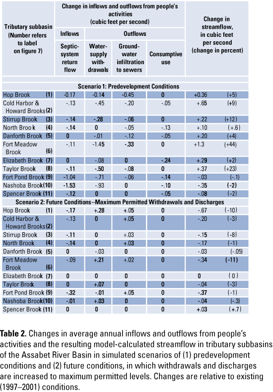
Understanding the present and simulating the futureOne way to understand how peoples activities affect conditions in the Assabet River Basin is to simulate the removal of all the water-management activities in the hydrologic system. Streamflows that result from this scenario approximate streamflows that might have occurred before water-resource development in the basin (that is, predevelopment conditions). A way to understand how peoples activities may further change hydrologic conditions is to simulate future water-use activities. The computer flow models were used to simulate these two conditions. In the first scenario (S1), water withdrawals, wastewater discharges, infiltration to sewers, septic-system return flows, and consumptive uses were set to zero, to simulate predevelopment conditions. In the second scenario (S2), water withdrawals and wastewater discharges were increased to levels currently permitted under the Massachusetts Water Management Act and the National Pollution Discharge Elimination System; the effects of new sewers also were simulated in the second scenario. Other scenarios simulated in the study are described by DeSimone (2004). Predevelopment ConditionsIn scenario S1, elimination of withdrawals, discharges, and other flows associated with peoples activities resulted in more streamflow in tributaries and less streamflow in the Assabet River. Increased average annual streamflows in tributaries ranged from 2 percent, in the Elizabeth Brook subbasin, to 44 percent, in the Fort Meadow Brook subbasin. In most subbasins, streamflow increases resulted from a variable combination of decreased withdrawals and decreased ground-water infiltration to sewers (table 2). Decreased withdrawals contributed most to the streamflow increases in the Assabet Main Stem Headwaters (not shown in table 2), Cold Harbor and Howard Brooks, Stirrup Brook, Fort Meadow Brook, and Taylor Brook subbasins. In the Hop Brook and Danforth Brook subbasins, decreased infiltration to sewers contributed most to increases in streamflow (table 2). In many subbasins, decreases in withdrawals and infiltration to sewers were offset by decreases in septic-system return flow, which was an inflow to the aquifer and augmented streamflow under simulated existing conditions. This happened in the Fort Pond Brook and Nashoba Brook subbasins, which have primarily public-water supply and private disposal. In the Elizabeth Brook subbasin, where private-water supply and disposal serve most of the population, the small streamflow increase resulted mostly from decreased consumptive use (table 2). A small decrease in streamflow in the Spencer Brook subbasin resulted from the elimination of a wastewater discharge. Changes in average monthly flows in scenario S1 relative to existing conditions varied during the annual cycle and among subbasins, depending on the variable monthly rates of withdrawals, infiltration to sewers, and other flows and on the response time of streamflow to these changes. Generally, changes were smaller fractions of total model-calculated streamflow during March, when overall flows were high, and changes were larger fractions of total streamflow during September, during the low-flow period. In March, increases in tributary streamflows ranged from less than 1 to about 20 percent. In September, increases ranged from 4 to more than 100 percent.
Along the main stem Assabet River downstream of the Headwaters subbasin (and downstream of the wastewater-treatment facility near the basin headwaters), model-calculated annual streamflows were slightly less (2 to 3 percent) in S1 than under existing conditions (fig. 8A). These streamflows were reduced because wastewater discharges, which augment streamflow under existing conditions, were eliminated in S1. In September, decreases in streamflow in the Assabet River ranged from more than 60 percent, downstream of the headwaters wastewater-treatment facility, to about 7 percent, at the confluence with the Sudbury River (fig. 8B). Increased Withdrawals and DischargesIn scenario S2, water withdrawals were increased from existing sources and a new source (supply well) was added in Westborough so that total withdrawals increased from 9.9 Mgal/d to maximum permitted levels of 12.2 Mgal/d. Wastewater discharges at existing treatment facilities were increased to the maximum permitted levels, and a new facility was added in Acton to increase total discharges from 11.0 Mgal/d to permitted levels of 15.0 Mgal/d. The effects of new sewers, mostly in Acton and Northborough, also were simulated, by decreasing septic-system return flow and increasing ground-water infiltration to sewers in these areas. Basinwide, septic-system return flow decreased from 4.3 Mgal/d to 3.0 Mgal/d, and infiltration to sewers increased from 2.6 Mgal/d to 2.9 Mgal/d. In this scenario, streamflow decreased in nearly all tributaries and increased in the Assabet River, relative to existing conditions (table 2 and figs. 8A and 8B). Decreases relative to existing conditions ranged from less than 1 percent, in the Danforth and Nashoba Brook subbasins, to about 10 percent, in the Hop and Fort Meadow Brook subbasins. In Hop, Fort Meadow, and Taylor Brook subbasins, increased withdrawals accounted for most of the decrease in streamflow; decreased septic-system return flow accounted for most of the decreased streamflow in other subbasins (table 2). As in scenario S1, changes in monthly model-calculated streamflows were largest relative to 19972001 flows in September, when decreases in model-calculated streamflows ranged from about 1 to 98 percent. In the Assabet River, other than in the main stem Headwaters subbasin (fig. 1), model-calculated streamflows for the S2 scenario increased to relative existing conditions (figs. 8A and B), because of increased wastewater discharges. In this scenario, the wastewater fraction of streamflow ranged from 69 to 10 percent annually (decreasing downstream from the headwaters wastewater-treatment facility, number 1 in fig. 8), and from 94 to 26 percent in September, both of which are increases of several percentage points relative to existing conditions. ReferencesDeSimone, L.A., 2004, Simulation of ground-water flow and evaluation of water-management alternatives in the Assabet River Basin, eastern Massachusetts: U.S. Geological Survey Scientific Investigations Report 2004-5114, 133 p. (Available online at http://water.usgs.gov/pubs/sir/2004/5114/.) Hutson, S.S., Barber, N.L., Kenny, J.F., Linsey, K.S., Lumia, D.S., and Maupin, M.A., 2004, Estimated use of water in the United States in 2000: U.S. Geological Survey Circular 1268, 46 pages. Massachusetts Department of Environmental Protection, 2003, Massachusetts Year 2002 integrated list of waters, Part 2Final listing of individual categories of waters: Boston, MA, Massachusetts Department of Environmental Protection, variously paged. U.S. Census Bureau, 2003, American Factfinder Census 2000 data sets: accessed January 2003 at http://factfinder.census.gov
|
|||||||||||||||||||||
AvailabilityThis report is presented in Portable Document Format (PDF). To view and print report you will need to have PDF Viewer or Adobe Acrobat Reader (available as freeware). Users with visual disabilities can click here for conversion tools and information to help make PDF files more accessible. Accessible text version (20 kilobytes) Printable PDF version (4.7 MB) -- 6 pages
Suggested citation for this report, in USGS format: DeSimone, L.A., 2005, People and Water in the Assabet River Basin, Eastern Massachusetts, FS-2005-3034, 6 p. For more information about USGS water activities in Massachusetts and Rhode Island, visit the USGS MA-RI Water Science Center Home Page. |
| AccessibilityFOIAPrivacyPolicies and Notices | |
 |
|