Increasingly, the Nation's water resources are vital to the long-term
health
of our citizens and the stability of our economy. These resources—our
rivers,
lakes, and aquifers—supply our drinking water, support our industries,
transport our
products, and provide us with recreational opportunities. Management of these
resources is a complex task involving all levels of government and a multitude
of
laws, regulations, and competing interests. The U.S. Geological Survey (USGS)
Cooperative Water Program has been providing basic scientific information needed
by
water-resources managers across the Nation since 1895.
 The
USGS Cooperative Water Program is an ongoing partnership between the USGS and
non-Federal agencies. The program jointly funds water-resources projects in
every State, Puerto Rico, and several other U.S. Trust territories. USGS employees
use nationally consistent procedures and quality-assurance protocols in conducting
cooperative projects. These standards ensure that all data from the Cooperative
Water Program are directly comparable from one region to another and available
from USGS databases for use by citizens, public officials, industry, and scientists
nationwide. Agencies, or "Cooperators," that participate in the
Cooperative Water Program are primarily State, Tribal, county, and municipal
agencies with water-resources management and policy responsibilities. In 2003,
more than 1,400 Cooperators participated in the program.
The
USGS Cooperative Water Program is an ongoing partnership between the USGS and
non-Federal agencies. The program jointly funds water-resources projects in
every State, Puerto Rico, and several other U.S. Trust territories. USGS employees
use nationally consistent procedures and quality-assurance protocols in conducting
cooperative projects. These standards ensure that all data from the Cooperative
Water Program are directly comparable from one region to another and available
from USGS databases for use by citizens, public officials, industry, and scientists
nationwide. Agencies, or "Cooperators," that participate in the
Cooperative Water Program are primarily State, Tribal, county, and municipal
agencies with water-resources management and policy responsibilities. In 2003,
more than 1,400 Cooperators participated in the program.
 In
terms of funding, the USGS contribution to the Cooperative Water Program in
federal fiscal year 2003 was $78.4 million; $64.4 million is from the Cooperative
Water Program federal appropriations, and an additional $14.0 million is from
two USGS bureau-level appropriations. These other two appropriations cover some
of the administrative and facilities costs attributable to the Cooperative Water
Program. Although the Program originated as a 50:50 fund-matching arrangement,
Cooperator funds have grown faster than USGS funds in recent years. In 2003,
Cooperative Water Program funds totaled $215.8 million. Cooperators contributed
$137.3 million, or nearly two-thirds of that total.
In
terms of funding, the USGS contribution to the Cooperative Water Program in
federal fiscal year 2003 was $78.4 million; $64.4 million is from the Cooperative
Water Program federal appropriations, and an additional $14.0 million is from
two USGS bureau-level appropriations. These other two appropriations cover some
of the administrative and facilities costs attributable to the Cooperative Water
Program. Although the Program originated as a 50:50 fund-matching arrangement,
Cooperator funds have grown faster than USGS funds in recent years. In 2003,
Cooperative Water Program funds totaled $215.8 million. Cooperators contributed
$137.3 million, or nearly two-thirds of that total.
— Tim Harbaugh, Director, Kane County,
Illinois Department of Environmental Management
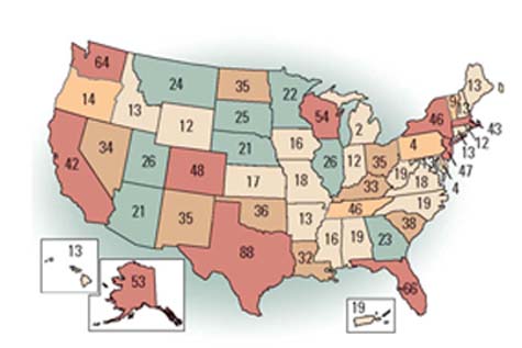 |
| During 2003, the U.S. Geological Survey was actively engaged in over 1,400 Cooperative Water Program funded water-resources monitoring efforts and investigative studies in every State, Puerto Rico, and several other U.S. Trust territories. |
The USGS and Cooperators jointly plan the scientific work performed in the Cooperative Water Program. This ensures that this work simultaneously meets the mission objectives of the USGS and the data and information needs of the Cooperators. The result is a national program with broad relevance and wide-spread use of its products. This significant tie to local and State water-resources needs also creates a program that responds quickly to emerging issues. Cooperators choose to work with the USGS because of the agency's broad technical expertise, its long-standing record of performing high-quality measurements and assessments, and its commitment to providing public access to data collected by the Cooperative Water Program. The scientific, non-regulatory mission of the USGS means that parties in many types of regulatory and jurisdictional disputes accept its data and analyses as valid. To ensure that these activities do not infringe on work more appropriately done by the private sector, the USGS distributes a list of activities that should be excluded from the Program, and works through the Federal Advisory Committee Act to obtain advice from both government and non-government entities.
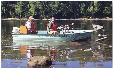 |
| Monitoring the health of the Nation's water supply. Measuring river flow along a tag line. |
The Cooperative Water Program supports the collection of basic hydrologic data, studies of specific water-resources problems, and hydrologic research. In 2003, for example, Cooperative Water Program funds supported about 4,200 stream-gaging stations. The program also funds approximately 750 interpretative projects annually targeted at specific issues, such as the effects of urbanization, dam removal, agricultural practices, and energy development on the quality and quantity of the Nation's water resources.
Because data collected in the Cooperative Water Program are directly comparable at the local, regional, and national levels, large-scale syntheses and application of these data to pressing societal and environmental issues are possible. Examples of these syntheses include using historical streamflow information to evaluate regional drought and climate variability, and developing a technique for estimating time of travel for rivers, which provides information for estimating the arrival time for accidental chemical spills.
 |
| A hydrograph retrieved from the National Water Information System (NWIS),
which includes online access to millons of water records. (http://water.data.usgs.gov/nwis) |
More recently, data from Cooperative Water Program interpretive projects continue to contribute significantly to emerging water-resources issues across the Nation. Examples include an improved understanding of the links between land-use changes and the physical habitat of streams (USGS Circular 1175), the behavior of freshwater-saltwater interactions in ground-water environments along the Atlantic coast (USGS Circular 1262), and the role of science in managing ground-water resources (USGS Circular 1247). Hydrologic data and results of interpretive projects are published as USGS reports, which are publicly available. In addition, more and more projects result in Internet products ranging from descriptive home pages and online reports, to interactive interfaces that allow users to run predictive models and conduct sophisticated statistical analyses by using data available online. Results from many of these interpretive projects, which are local or regional in scope, have broad transferability to other parts of the Nation where similar water-resources issues exist.
Data collected by the Cooperative Water Program are incorporated into the National
Water Information System (NWIS). The NWIS contains hydrologic information collected
by the USGS during the past 120 years. It includes streamflow data from 21,000
sites, water levels from over 1,000,000 wells, and chemical data from rivers,
streams, lakes, springs, and ground water at 338,000 sites. All of these data
are publicly available, and can be readily accessed on the Internet at
http://waterdata.usgs.gov/nwis/.
During 1999, the Cooperative Water Program underwent an extensive review by
stakeholders external to the USGS—the first such review in the program's
history. The Review Committee provided many insightful observations and recommendations,
found at
http://water.usgs.gov/coop/review.html,
about the Cooperative Water Program that will help the USGS to maintain the
Program's core strengths while leading to significant improvements. More
detailed information describing the mission, goals, activities, and accomplishments
of the Cooperative Water Program can be found at
http://water.usgs.gov/coop/.
Ward Staubitz
Cooperative Water Program Coordinator
U.S. Geological Survey
409 National Center,
Reston, VA 20192
(703) 648-5061,
email: staubitz@usgs.gov
This report is available online in Portable Document Format (PDF). If you do not have the Adobe Acrobat PDF Reader, it is available for free download from Adobe Systems Incorporated.
Download the report (PDF, 860 KB)
Document Accessibility: Adobe Systems Incorporated has information about PDFs and the visually impaired. This information provides tools to help make PDF files accessible. These tools convert Adobe PDF documents into HTML or ASCII text, which then can be read by a number of common screen-reading programs that synthesize text as audible speech. In addition, an accessible version of Acrobat Reader 5.0 for Windows (English only), which contains support for screen readers, is available. These tools and the accessible reader may be obtained free from Adobe at Adobe Access.
| AccessibilityFOIAPrivacyPolicies and Notices | |
 |
|