
MAJOR FINDINGS
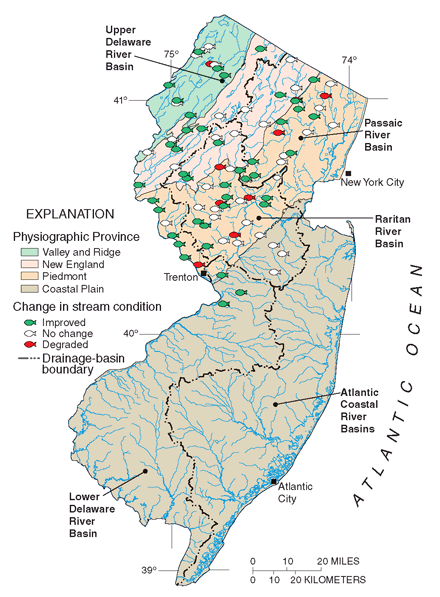 |
| Figure 5. Stream conditions for fish communities have improved from the 1970s to the 1990s at 41 of 88 sites in northern New Jersey. |
Stream Conditions for Fish Have Improved Since the 1970s
Fish are useful indicators of environmental changes in drainage basins because they are sensitive to a wide variety of stresses including changes in water chemistry and flow, modifications in habitat and food, and landscape alterations resulting from urbanization and other human-related activities. Moreover, fish accumulate certain contaminants within their tissues over their entire life span (Fausch and others, 1990; Karr and others, 1987, Chang and others, 2000). One way to identify environmental changes in watersheds is to assess changes in stream condition by use of an Index of Biotic Integrity (IBI; blue text box below). On the basis of IBI results, conditions for fish in streams of the Delaware, Passaic, and Raritan River Basins have improved since the 1970s (fig. 5; table 2) (Chang and others, 2000).
Of the 88 sites assessed, stream condition improved at 46 percent, worsened at only 13 percent, and remained the same at 41 percent from the 1970s to the 1990s (fig. 5).
Many factors, especially the improved treatment of wastewater discharges during the 1980s and changes in land-use practices, may have contributed to the statistically significant increase in IBI scores in all three basins (table 2). Nonpoint sources were less of a factor than were point-source improvements; but as discussed on pages 7 and 8, urban nonpoint influences are still significant. The Delaware River Basin reflected the greatest improvement in stream condition, moving from a condition category of fair up to good (table 2).
A change in stream condition also can be assessed by comparing the percentage composition of the fish families (fig. 6). For example, the highly contaminant-tolerant white suckers made up a greater percentage of the fish communities in all basins during the 1970s than in the 1990s, especially in streams in the Delaware River Basin. In addition, during the 1990s, darters, of which many species (for example, the shield darter) are highly intolerant of human disturbance and habitat modification, increased in abundance in streams in the Passaic and Raritan River Basins and remained unchanged in streams in the Delaware River Basin.
Many minnow species are indicators of good stream condition because they rely directly on the availability of aquatic insects for survival. Thus, as streams become degraded and insects and their larvae become scarcer, the numbers of insect-eating minnows often decrease. Minnows made up greater than 42 percent of the community during the 1970s and 1990s in all three river basins (fig. 6). The percentage of minnows increased in Delaware River streams. Minnows decreased slightly in the Passaic and Raritan River streams, however, an indication that these two basins may still reflect some degree of impairment.
| Table 2. The mean Index of Biotic Integrity (IBI) scores for streams of the Delaware, Passaic, and Raritan River Basins have increased significantly from the 1970s to the 1990s. [n, the number of stream sites assessed; * indicates a significant change in mean IBI score (Chang and others, 2000)] |
||||||||||
| Index | Delaware River (n=32)
|
Passaic River (n=24)
|
Raritan River (n=32)
|
|||||||
|---|---|---|---|---|---|---|---|---|---|---|
| Mean Index of Biotic Integrity score |
|
|
|
|||||||
| Condition rating |
|
|
|
|||||||
| Index of Biotic Integrity (IBI)Ten community measures (often called biometrics) based on the number of fish species, feeding habits, abundance, and health are used to evaluate the biological integrity of streams. A score of 1, 3, or 5 is assigned to each community measure on the basis of overall similarity to an appropriate regional reference site, 5 indicating most similar and 1 indicating least similar to reference conditions. Scores for individual community measures at each sampling location are then summed to produce a total score, which is assigned a condition category. The maximum score a site can receive is 50 and the minimum is 10. The four condition categories are excellent (4450), good (3743), fair (2936), and poor (10-28) (Kurtenbach, 1993). The IBI serves as an integrated analysis because individual biological measures provide differing levels of sensitivity to changes in biological condition (Barbour and others, 1999). |
These differences, perhaps, may explain why the mean IBI score for streams in the Delaware River Basin increased slightly more than that for streams in the Passaic or Raritan River Basins (table 2). Other fishes (such as eels) were not included in this comparison because they are found over a large range in water-quality and habitat conditions, thus limiting their use as aquatic indicators (Kurtenbach, 1993). Chang and others (2000) provide information on collection methods, fish taxonomy, and variability between the 1970s and 1990s collections.
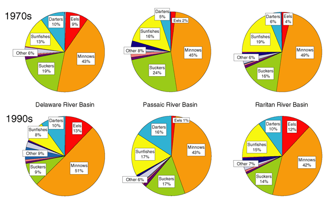 |
| Figure 6. Changes in the percentage of fish families (that is, a decrease in suckers and a general increase in darters) captured in streams of the Delaware, Passaic, and Raritan River Basins during the 1970s (top) and the 1990s (bottom) indicate that stream conditions have improved. |
Aquatic Invertebrate Communities Differ Naturally Across the Study Area
The New Jersey Department of Environmental Protection (1994b) established 43 reference or benchmark sites whose drainage basins have been minimally disturbed by human activity. A comparison of these sites indicates that the aquatic invertebrate communities in the southern New Jersey Coastal Plain are distinctly different from those in the north as a consequence of natural differences in environmental and physical conditions (table 3). Thus, natural variability in aquatic invertebrates needs to be taken into account when assessing communities across the entire study area. This finding helped focus our data-collection efforts toward gaining a better understanding of urban influences on northern New Jersey communities. In addition, analysis of LINJ NAWQA data indicates that aquatic-invertebrate communities on Long Island closely resemble New Jersey Coastal Plain communities because of similar physiographic and habitat conditions.
| Table 3. Differences in aquatic-invertebrate communities in reference streams between northern and southern (Coastal Plain) New Jersey can be explained by natural differences in environmental conditions |
||
| Northern New Jersey | Southern New Jersey | |
|---|---|---|
|
Most abundant aquatic invertebrates |
Mayflies, stoneflies, caddisflies, and riffle beetles |
Worms, freshwater clams, black flies, midges, caddisflies, and stoneflies |
|
Environmental characteristics |
Steeper channels and higher dissolved oxygen content |
Low pH and low dissolved solids and nutrient content |
| Streambed characteristics |
Mainly rock and cobble | Mainly sand and other fine sediments |
Fish and Aquatic Invertebrate Communities Are Impaired in Urban Areas
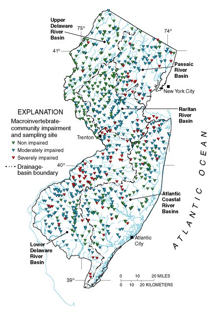 |
| Figure 7. Aquatic-invertebrate-community data at more than 700 New Jersey AMNET sites (blue text box above) commonly indicate moderate to severe impairment in higher density urban areas (gray areas in fig. 1, p. 3). |
Despite some overall improvements in stream condition (p. 5), fish and aquatic-invertebrate communities are commonly impaired in the urbanized parts of New Jersey (figs. 7 and 8; see also fig. 1 on p. 3 for a comparison with urban area). Community-impairment scores at more than 150 fish-sampling sites (Kurtenbach, 1993) and more than 700 aquatic-invertebrate sampling sites (for example, New Jersey Department of Environmental Protection, 1994a) in New Jersey were examined with respect to land use and other basin characteristics. The northwestern part of the State is less developed and consequently was least likely to reflect moderately or severely impaired aquatic communities (figs. 7 and 8).
The percentage of urban area in the drainage basin and the amount of treated wastewater flows upstream from sampling sites were the primary factors related to a severely impaired aquatic-invertebrate community (Kennen, 1999). Total amount of forest land in the basin, however, was a strong mitigating factor and increased the likelihood of an unimpaired aquatic-invertebrate community. Similarly, total population in proximity to the sampling site and the amount of urban land in a basin were found to be most highly related to poor fish-community conditions.
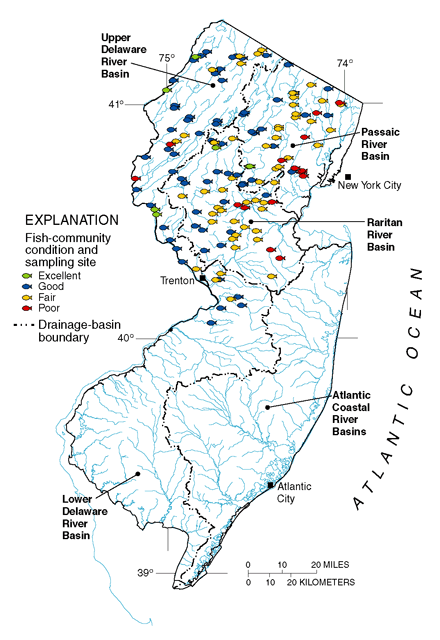 |
| Figure 8. Fish-community data at more than 150 sampling sites in northern New Jersey indicate that streams in urban areas are in poor to fair condition (based on IBI scores; blue text box on p. 5). |
| New Jersey Department of Environmental Protections Ambient Biomonitoring Network (AMNET) is a statewide network of more than 700 aquatic-invertebrate sampling sites that was designed to monitor the condition of aquatic-invertebrate communities in five water-management areas on a 5-year rotational basis. This sampling frequency is considered to be realistic for evaluating long-term environmental changes. Sampling locations (fig. 7), which were chosen in a stratified-random design to monitor all nontidal streams at approximately 3-mile intervals, include 43 reference sites. In addition, this network was designed to incorporate, wherever possible, existing USGS and NJDEP cooperative water-quality monitoring stations to maximize the integration of water-quality and biological information. Level of community impairment (non-impaired, moderately impaired, and severely impaired) is based on a modification of the USEPA Rapid Bioassessment Protocol II (Plafkin and others, 1989). |
The following section describes an extension of these analyses of available data through an integrated study of the specific factors that affect biological communities in urban environments.
Characteristics of Urban Landscapes That Affect Aquatic Communities
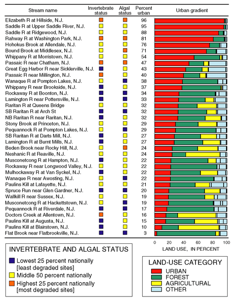
More than 400 landscape and environmental variables were aggregated for comparison with data describing fish, invertebrate, and algal communities at 36 streams in New Jersey and Long Island. Sites were chosen with drainage basins that ranged from 3 to 96 percent urban land. Analyses of these data indicated that increasing impairment of fish, aquatic-invertebrate, and algal communities was statistically related to components of the urban gradient (table 4; refer also to Glossary, p. 31).
| Table 4. Environmental factors that were highly related to impairment of fish, aquatic-invertebrate, and algal communities along an urban land-use gradient. Green shading indicates factors that were more favorable to healthy aquatic communities and red shading indicates factors that were less favorable. [NS, No statistically significant effect on aquatic community] |
||||
| Response of aquatic community | ||||
|---|---|---|---|---|
| Watershed characteristic | Fish | Aquatic invertebrates | Algae | |
| Area of forest and wetlands |
NS |
Positive |
NS |
|
| Ability to maintain base flow |
NS |
Positive |
NS |
|
| Percentage of cobble substrate |
Positive |
Positive |
NS |
|
| Median sulfate concentration |
NS |
Positive |
Positive |
|
| Median total phosphorus concentration |
Negative |
NS |
Positive |
|
| Mean annual flood |
Negative |
Negative |
Negative |
|
| Flashiness of streamflow |
Negative |
NS |
NS |
|
| Impervious area, road area only |
Negative |
Negative |
Negative |
|
| Impervious area, nonroad area only |
NS |
Negative |
NS |
|
| Population density |
Negative |
Negative |
Negative |
|
| Total urban area in 1986 |
Negative |
NS |
NS |
|
| Urban area growth from 1986 to 1995 |
NS |
Negative |
NS |
|
| Commercial and industrial area in 1986 |
NS |
Negative |
Negative |
|
| Total point-source flow |
NS |
Negative |
NS |
|
Environmental factors such as annual peak discharge, amount of impervious road area, and population density were related to impairment in all three types of aquatic communities (negative in table 4). Some environmental factors such as point-source flow, urban growth during 198695, and impervious nonroad area were related to impairment in the aquatic-invertebrate community only (negative in table 4). In addition, total urban area in 1986 appeared to be important only for the fish community. Other studies have found that historical changes in land use may have significant implications for longer-lived organisms such as fish.
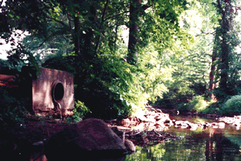 |
| Figure 9. Unregulated impervious-area runoff directly affects water quality, habitat, and aquatic communities in streams and is exemplified by a storm-sewer pipe (left) that drains directly into the Saddle River at Ridgewood, N.J. |
The presence of cobble substrate was a factor contributing to healthier fish and aquatic-invertebrate communities (positive in table 4). Degradation of cobble and other stream habitat in urban systems likely is related to increases in flow, channel erosion, and sedimentation common to minimally controlled urban stormwater runoff (fig. 9).
In fact, changes in hydrologic factors (such as decreases in base flow and increases in peak discharge and the flashiness of streamflow) play a major role in influencing the types and condition of aquatic communities present in a stream (table 4, fig. 10), in large part, by the way these changes in flow affect stream habitat. As a result, stream communities are continually stressed and rarely reach stable population levels in urban systems. Conversely, reductions in base flow resulting from changes in water-use and wastewater distribution practices greatly influence the suitability of a stream for many types of organisms (Klein 1979). The area of forest and wetlands in the drainage basin was a positive factor in the health of aquatic-invertebrate communities (tables 4 and 5). Forests and wetlands play a major role in maintaining a healthy supply of water, food, and habitat for disturbance-intolerant and highly desired species. Thus, forest and wetlands are able to help mitigate the undesirable effects of other human-induced landscape alterations.
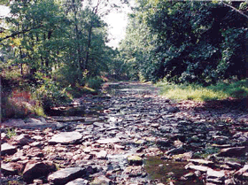
| Figure 10. Reductions in base flow of streams resulting from changes in up stream land-use and water-use practices affect the distribution of aquatic species in streams. For example, the difference in wetted habitat for median-flow conditions (upper photograph) and low-flow conditions (bottom photograph) at Neshanic River at Reaville, N.J., is substantial, although not entirely related to human activities. | 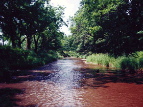 |
 |
Organochlorine Compounds Were Detected in Streambed Sediment and in Fish Tissue
Even though the use of many organochlorine compounds has been discontinued, the widespread historical application and the environmental persistence of compounds such as chlordane, dieldrin, DDT, and PCBs have led to frequent detection in streambed sediment and in whole-fish tissue samples in Long Island and New Jersey (Stackelberg, 1997; Long and others, 2000). Analyses of available bed-sediment chemical data for nearly 300 sites (Stackelberg, 1997) indicate that chlordane and dieldrin concentrations in bed sediments were highest in urban areas, reflecting their past use for termite control. Concentrations of DDT and PCBs were highest in urban and industrial areas, reflecting their principal historical use as an insecticide and an industrial chemical (in hydraulic lubricants and heat-resistant oils in electrical transformers), respectively. No significant relations were found, however, between chlorinated hydrocarbon concentrations in bed-sediment and whole-fish samples (white sucker, the chosen target species for this analysis) or between those in whole-fish samples and land use (Long and others, 2000).
| Table 5. Comparison of biological status at 36 Long IslandNew Jersey stream sites to 140 NAWQA sites nationwide indicates that the high scores relative to other NAWQA sites are associated with urban watersheds. Sites are ordered from top to bottom in descending percentage of urban land (urban gradient) |
 |
| Organochlorine pesticides in the environmentFollowing discovery of the tremendous insecticidal properties of DDT in the 1940s, numerous organochlorine insecticides (for example, dieldrin, chlordane, heptachlor, and DDT) were developed and used extensively for the control of agricultural pests as well as termites in residential and commercial settings. DDT was also used historically to control mosquito and gypsy moth populations in residential and forested areas. The use of these insecticides peaked in the 1960s, but because of concerns over their toxic effects and tendency to bioaccumulate, restrictions on their use began in the 1970s; all uses of these organochlorine insecticides were discontinued by the mid-1980s. The residues of organochlorine insecticides are, however, extremely persistent in the environment. Once introduced into the aquatic environment, the lipophilic (fat-loving) nature of these compounds allows them to bioaccumulate and ascend through the food chain, often resulting in adverse effects on many aquatic species and fish-eating birds and wildlife. |
Of the eight streams sampled in fall 1997, one-half of all bed-sediment samples contained concentrations of chlordane, DDT, and PCBs that exceeded threshold effect levels (fig. 11; blue text box on p. 12; Long and others, 2000). Concentrations of chlordane and PCBs in whole-fish samples from many of the sites exceeded established guidelines for fish-eating wildlife. Some of the detected compounds are known to pose human health risks; however, concentrations in whole-fish samples from this study are not directly comparable to concentrations in edible portions (fillets) that are used to establish U.S. Food and Drug Administration (FDA) action levels for human consumption (U.S. Food and Drug Administration, 1992). Nonetheless, the FDA action levels for human consumption of total chlordane [300 µg/kg (micrograms per kilogram)], total DDT (5,000 µg/kg), and total PCBs (2,000 µg/kg) in edible portions of fish were not exceeded in the whole-body samples at any of the sites. Organochlorine compounds in lake-sediment cores and in water samples are discussed on pages 14 and 20, respectively.

Trace-Element Concentrations Were Elevated in Streambed Sediment, Fish Tissue, and Ground Water
Human activities have accelerated the release of trace elements to aquatic environments through point- and nonpoint-source contamination (blue text box below). Analyses of available bed-sediment chemical data for nearly 300 sites (O'Brien, 1997) indicated that trace-element concentrations in bed sediments were generally higher in the northern New Jersey physiographic provinces (related to urban development and geologic availability) and lower in the Coastal Plain (related to lower organic content of sediments, geologic availability, and stream-water pH). Higher copper, lead, and zinc concentrations were correlated with increased population density; zinc was correlated with wastewater-treatment-plant flows; higher arsenic was correlated with increased agricultural land use; and higher chromium was correlated with certain geologic deposits (especially in the New England Physiographic Province).
All eight of the streams sampled during fall 1997 were found to have at least two trace elements that exceeded TELs in bed sediment (fig. 11; Long and others, 2000; blue text box on TELs and PELs below). Concentrations of eight trace elements at Rahway River near Springfield (fig. 11) exceeded TELs; arsenic, cadmium, and copper also exceeded PELs.
| Trace elements in the environmentGeologic weathering accounts for natural releases of trace elements to aquatic environments. Human activities, however, have accelerated the release through point- and nonpoint-source contamination. Historically, industrial and other point sources were significant, as were releases from fossil-fuel burning and use of trace-element-based pesticides. More commonly now, trace elements from atmospheric deposition, vehicular traffic, and other activities accumulate on urban surfaces and are subsequently carried in runoff to streams. When introduced into aquatic environments, trace elements adsorb to fine-grained sediments (Forstner and Wittman, 1983). Trace elements can accumulate in sediments and may affect the health of bottom-dwelling (benthic) organisms and higher trophic-level species (fish) that rely on benthic organisms for food. Although some trace elements such as copper, iron, manganese, selenium, and zinc are vital to the metabolic processes of aquatic organisms, they can still be toxic at high concentrations. |
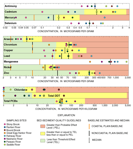 |
| Figure 11. Concentrations of selected trace elements and organochlorine compounds in bed sediment commonly exceeded TEL and PEL guidelines, especially at urban sites. (Background concentrations were estimated using method of Velz (1984); see blue text box below concerning TELs and PELs.) |
Copper, manganese, mercury, and selenium were detected in fish livers at all sites. No significant relations were found between trace-element concentrations in fish livers and those in bed sediment or between concentrations in fish livers and any land-use category or population density (Long and others, 2000).
Arsenic was detected in 17 of 22 samples collected from domestic-supply (household) wells completed in fractured bedrock aquifers of the Piedmont Physiographic Province, where geologic formations are known to contain arsenic-bearing minerals. Concentrations ranged from 1 to 57 µg/L. The current drinking-water standard for arsenic is 50 µg/L, but the USEPA has proposed a tenfold decrease in this standard to 5 µg/L. Six of the samples (27 percent) contained arsenic in concentrations equal to or greater than 5 µg/L.
Concentrations of radium (sum of Ra-226 and Ra-228) above the drinking-water standard were found in 33 percent of 170 wells sampled in the surficial aquifer system in southern New Jersey (Szabo and others, 1997). The highest radium levels were in areas where acidic waters are associated with surficial sediments that contain radium from geologic sources (primarily the Bridgeton Formation) and agricultural areas where use of nitrogen fertilizers and lime is heavy. The leaching and nitrification of applied fertilizers, which increase the dissolved-solids content and acidity of ground water, are likely mechanisms by which radium is mobilized from surficial sediments and transported to ground water. More recently, the short-lived isotope radium-224 was detected in samples from this surficial aquifer system in waters affected by the same chemical processes (Zoltan Szabo, U.S. Geological Survey, written commun., 2000).
In a 59-well subset of the 170 wells above, mercury was detected at concentrations above the drinking-water standard of 2 µg/L in about 10 percent of the samples. The source is suspected to be linked to past use of mercury-based pesticides. Mercury may have increased mobility as a result of the natural acidity of waters from the surficial aquifer in southern New Jersey, as well as widespread contamination of these waters with chloride from road salt, septic systems, and other discharges; but the mechanisms are as yet not well understood.
| TELs and PELsCurrently, there are no U.S. standards for assessing the potential for adverse biological effects due to contaminated freshwater sediment. The Canadian Council of Ministers of the Environment (CCME) modified an approach by Long and Morgan (1991) to develop guidelines for marine and freshwater sediments. The CCME modified approach uses two assessment levels: (1) the threshold effect level (TEL), representing the concentration below which adverse effects are expected to occur rarely, and (2) the probable effect level (PEL), representing the concentration above which adverse effects are expected to occur frequently (Ecosystem Conservation Directorate Evaluation and Interpretation Branch, 1995). Concentrations between TELs and PELs are values at which occasional adverse biological effects are expected. Adverse biological effects are generally defined as effects that are considered to produce a negative response in an organism (for example, death, reduction in growth, or reduced reproductive success). |
|
During summer 1998, the LINJ study participated with 20 other NAWQA
studies in a national survey (Krabbenhoft and others, 1999) in which
bed sediment samples were analyzed for total mercury and methylmercury,
and fish-muscle tissues (fillets) were analyzed for total mercury
(assumed to be predominantly methylmercury). Four sites were sampled
in the LINJ study area (map on p. 28).
Atmospheric deposition is the primary source of mercury to most aquatic ecosystems in the eastern United States; in some areas, however, urban, industrial, mining, volcanic, and (or) geothermal sources contribute to elevated concentrations of total mercury in bed sediment. In addition, past use of mercury-based pesticides on golf courses and certain agricultural crops are possible sources. Mercury is readily methylated in the natural environment as a result of bacterially mediated sulfate reduction. Methylmercury is readily bioaccumulated and biomagnified, is the primary form of mercury in fish, and is a potent neurotoxin to humans and wildlife (fish, birds, and mammals). At the LINJ sites, mercury concentrations in fish tissue (pickerel fillets) normalized by mean weight were positively related to methylmercury concentrations in water and negatively related to total mercury concentrations in bed sediment. These data indicate that mercury concentrations in fish tissue are more a function of methylmercury levels in water than in the sediment. This is consistent with results found nationally in fish tissue (Dennis Wentz, U.S. Geological Survey, written commun., 2000). The highest concentrations of mercury in fish tissue [near 0.5 µg/g (micrograms per gram) wet weight] were from the mixed-land-use site (Great Egg Harbor River), where relatively high percentages of wetlands may enhance methylation rates. Concentrations of mercury in fish tissue were intermediate in urban basins and lowest in the agricultural basin. Nationally, background and mixed (agricultural and forested) basins had the highest mean mercury methylation efficiencies (as measured by the ratio of methyl-mercury to total mercury) in water. Mixed (agricultural and forested) basins had the highest mean methylation efficiencies in bed sediment; methylation efficiencies in background, agricultural, and urban basins were lower. |

|

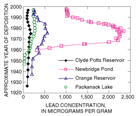
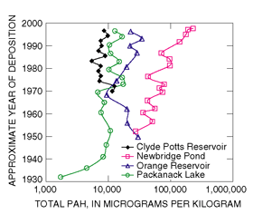
| Lake-sediment cores were useful for discerning chemical-use historyLakes are more representative of a stable depositional environment than streams. Differences in sediment concentrations between the lake-sediment cores are related to differences in sedimentation rates and to factors affecting chemical inputs such as population density, traffic density, chemical use, and the extent of urban land use in the watershed. For example, even though the concentrations are different, the reduction of contaminants regulated by environmental legislation (chlordane, PCBs, DDT, and lead) is clearly evident in the sedimentary record for the three urban lakes. Bed-sediment chemical data from streams, although useful for determining the relative effects of basin land use, had large within-site sample variability and were not particularly useful for trend detection, even with 25 years of data (Stackelberg, 1997; O'Brien, 1997). This finding is typical of streambed-sediment data because sediments of different ages and different sources are continuously being mixed by changing hydrologic conditions. |
| Table of Contents || Previous Section || Next Section || Glossary U.S. Geological Survey Circular 1201 Suggested citation:
|
