
The USGS NAWQA Program includes an assessment of fish communities as one of the measures of water quality. Because fish communities are strongly influenced by their habitat, instream habitat conditions also are assessed. Combining the habitat data, the biological-community data, and the water-chemistry data provides opportunities for developing a comprehensive understanding of the aquatic life in a stream. Additionally, habitat analyses can assist in the identification of limiting physical or chemical factors critical to establishing or maintaining healthy biological communities in the streams.
Stream-habitat characteristics were related to fish-community degradation at three very different stream reaches in the Trinity River Basin. The reaches were chosen to reflect major differences in environmental settings, flow conditions, land uses, and stream biota. West Fork Trinity River is a relatively large stream in an urban area; Chambers Creek is a relatively large stream draining an intensively farmed area; and Menard Creek is considered a reference site (minimally affected by human activities) in the forested lands of southeast Texas.
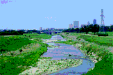
West Fork Trinity River: The West Fork Trinity River reach is a few miles east of downtown Fort Worth and in the Central Oklahoma/Texas Plains Ecoregion (Omernik, 1987). This reach of the West Fork Trinity River has been channelized and leveed for flood control. The channel substrate is coarse, dominated by cobble and gravel from outcrops of limestone. Flows in the reach respond quickly to precipitation. However, upstream reservoirs tend to moderate low and high flows.
Chambers Creek: The Chambers Creek reach is in the Blackland Prairie Ecoregion, which is the most intensively cultivated ecoregion in the basin. The major crops are cotton, sorghum, corn, and wheat. This region is characterized by heavy clay soils, little relief, and stream channels in the lower part of the basin that have been straightened and leveed for flood control. Streams in this ecoregion respond to heavy precipitation with rapid rises and falls in stage and large sediment loads.
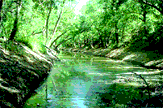
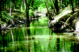
Menard Creek: The Menard Creek reach is in the Western Gulf Coastal Plain Ecoregion and in the National Park Service's Big Thicket Preserve. Adjacent land use is dominated by silviculture; however, the riparian zone and, to some extent, the flood plain contain secondary vegetative growth that has not been disturbed for many years. The watershed is characterized by acidic sandy soils, little relief, and meandering channels. Floods are attenuated by flood-plain and riparian vegetation, and stream stages change gradually.
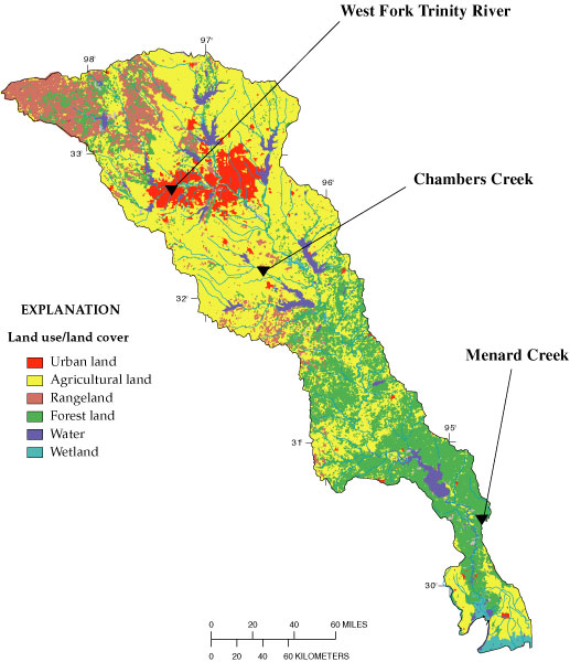
Land use and land cover and location of selected survey reaches.
Stream-Habitat Characteristics
The physical and chemical characteristics of water combined with the physical features of the stream channel influence the presence or absence of particular aquatic organisms in a stream. Habitat affects species distributions at different spatial scales. For example, fish-species distribution in a stream reach is affected by climate on a regional scale, channel gradient on a local scale, and particle size of substrate at a very detailed scale. Other important factors such as stream meandering, steepness of banks, riparian vegetation, and variability of streamflow affect the habitat for fish in the stream. Not only does stream habitat have to be suitable for a particular species, it also has to support other biota that are prey for the species.
The measured habitat characteristics at the three stream reaches strongly reflect the differences in habitat among the reaches. The low bank height/channel width ratio and high density of woody vegetation in the Menard Creek reach create a setting where woody snags and logjams provide habitat for fish and an excellent environment for biota that supply food for fish. The low bank height/channel width ratio indicates bank stability and a lack of channel incision or cutting. The high density of woody vegetation moderates temperature, corresponds to stable banks with little erosion, and provides a source of organic material to the stream.
In contrast, the low sinuosity (meandering) and low channel gradient in the Chambers Creek reach could limit the number and size of pools and ripples that create a variety of habitats. Variety of habitat provides more opportunity for large numbers and varieties of species to thrive. The high variation in flow at Chambers Creek is associated with more frequent floods, in which organisms can be physically harmed or swept away, and more frequent very low flows, in which the volume of water is limited and species are subject to large and rapid changes in the pH, dissolved oxygen, and temperature of the water.
The high bank height/channel width ratio and low density of woody vegetation at the West Fork Trinity River site can be attributed to stream channelization associated with urban flood control. Channelization has resulted in a stream reach with little or no woody riparian vegetation to contribute structure and habitat to the channel. Channelization also causes deeper channel incision, which reduces the amount of stream-margin habitat for aquatic organisms.
Stream-habitat characteristics
| Stream | Sinuosity (meandering (dimensionless) |
Channel gradient feet/mile) |
Bank height/ channel width ratio (dimensionless) |
Density of woody vegetation (dimensionless) |
Variation of monthly flow index dimensionless |
|---|---|---|---|---|---|
| West Fork Trinity River |
2.2
|
6.
|
0.75
|
3.4
|
39
|
| Chambers Creek |
1.1
|
1.1
|
.60
|
7.1
|
82
|
| Menard Creek |
1.9
|
10.6
|
.24
|
20.4
|
26
|
 West Fork Trinity River. |
||
 Chambers Creek. |
||
 Menard Creek. |
The evaluation of fish-community degradation involved measures of the percentage of fish species in a reach that (1) are known to be tolerant of severe environmental stresses, (2) are known to be omnivorous, (3) are not native to the stream, and (4) have physical anomalies that can be visually detected. The fish-community degradation index is computed from the frequency of nonnative, tolerant, and omnivorous individuals at a site and from the frequency of external anomalies observed for each species of fish.
The table shows that Menard Creek, with an index of 6, is the least degraded of the three reaches discussed here. Menard Creek percentages are lowest in all the measured categories. The Menard Creek habitat and quality of water support a robust fish community. The two other reaches, West Fork Trinity River and Chambers Creek, each have an index of 12. These two reaches are examples of highly altered streams characterized by incised and leveed channels, low density of vegetation in the riparian zones, and unstable streamflow characteristics. These and other factors, possibly including water-chemistry conditions, have contributed to degraded fish communities.
In the West Fork reach, the percentage of fish with external anomalies is the greatest among the three reaches. The relatively large incidence of external anomalies could be related to the quality of water and sediment originating in the urban area. In a separate study of organic contamination in bed sediment and tissue of aquatic biota, Moring (1997) reports the occurrence and degree of contamination in streambed sediments and tissues of aquatic biota in the Trinity River Basin to be much greater in urban streams than in non-urban streams.
Fish-community degradation
| Stream | Tolerant species |
Omnivorous species (percent) |
Nonnative species (percent) |
External anomalies (percent) |
Fish- community degradation index |
|---|---|---|---|---|---|
| West Fork Trinity River |
50
|
30
|
3
|
2.8
|
12
|
| Chambers Creek |
53
|
26
|
0
|
2.2
|
12
|
| Menard Creek |
37
|
8
|
0
|
.9
|
6
|
| AccessibilityFOIAPrivacyPolicies and Notices | |
 |
|