 About the cover:
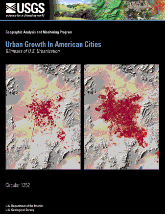
These two images of Las Vegas, Nevada, show urban extent as it was in 1973 and 1992. Between these years, the urban area grew dramatically throughout the level basin. Visible in each image are local landforms, such as the surrounding mountain ranges and Lake Meade. Read more about the growth of Las Vegas on pages 20 and 21.
Urban Growth in American Cities
Glimpses of U.S. UrbanizationBy Roger Auch1, Janis Taylor1, and William Acevedo2
January 2004
1 SAIC TSSC, work performed under U.S. Geological Survey contract 03CRN001; Raytheon ITSS, work performed under U.S. Geological Survey contract 1434-CR-97-CN-40274.
2 U.S. Geological Survey
Circular 1252
U.S. Department of the Interior
U.S. Geological Survey
U.S. Department of the Interior
Gale A. Norton, Secretary
U.S. Geological Survey
Charles G. Groat, Director
U.S. Geological Survey, EROS Data Center; 2003
Free on application to U.S. Geological Survey Information Services
Box 25286, Denver Federal Center
Denver, CO 80225
For more information about the USGS and its products
Telephone: 1-888-ASK-USGS
World Wide Web: http://www.usgs.gov
Any use of trade, product, or firm names in this publication is for descriptive purposes only and does not imply endorsement by the U.S. Government.
Although this report is the public domain, it contains copyrighted materials that are noted in the text. Permission to reproduce those items must be secured from the individual copyright owners.
Table of Contents
Purpose and IntroductionGrowth of Urban Areas
Locator Map
Historical Comparisons of Metropolitan Regions
Atlanta, Georgia
Boston, Massachusetts
Chicago, Illinois
Denver, Colorado
Houston, Texas
Las Vegas, Nevada
Memphis, Tennessee
Minneapolis-St. Paul, Minnesota
Orlando, Florida
Phoenix, Arizona
Pittsburgh, Pennsylvania
Raleigh-Durham, North Carolina
Reno-Sparks, Nevada
Sacramento, California
Seattle-Tacoma, Washington
Tampa-St. Petersburg, Florida
Ongoing Urban Dynamics Research
Acknowledgments
Bibliography
Urban Growth in American Cities
Glimpses of U.S. Urbanizationby: Roger Auch, Janis Taylor, and William Acevedo
The Earth's surface is changing rapidly. Changes are local, regional, national, and even global in scope. Some changes have natural causes, such as earthquakes or drought. Other changes, such as urban expansion, agricultural intensification, resource extraction, and water resources development, are examples of human-induced change that have significant impact upon people, the economy, and resources. The consequences that result from these changes are often dramatic and widespread (Buchanan, Acevedo, and Zirbes, 2002)
It is the role of the U.S. Geological Survey (USGS) to provide useful and relevant scientific information both to the agencies within the Department of the Interior and to the Nation in general. In an effort to comply with this task, USGS scientists are assessing the status of, and the trends in, the Nation's land surface. This assessment provides useful information for regional and national land use decisionmaking. This knowledge can be used to deal with issues of significance to the Nation, such as quality-of-life, ecology of urban environments, ecosystem health, ecological integrity, water quality and quantity concerns, resource availability, vulnerability to natural hazards, safeguards to human health, air and land quality, and accessibility to scientific information. Results of these assessments can also be analyzed to reveal rates and trends in land use change. Results from urban growth studies provide a firm foundation for continuing research that explores the consequences of human modification of the landscape.
The USGS seeks to illustrate and explain the spatial history of urban growth and corresponding land use change. Scientists are studying urban environments from a regional perspective and a time scale of decades to measure the changes that have occurred in order to help understand the impact of anticipated changes in the future.
Within this booklet are pairs of images of selected urbanized regions from across the Nation. These image pairs illustrate the transformation that these areas have undergone over two decades. Specifically, they depict changes in the extent of urban land. Each change pair is composed of one image from the 1970s and one image from the 1990s. Accompanying each image pair is a brief historical geography of factors that helped facilitate major changes that have occurred since the founding of the main city and the consequences and challenges of regional urban growth. The goal of this publication is to provide an illustration of urban change that is easily understood by a broad audience.
The images used throughout this booklet were generated from land cover data developed by the USGS. The data sources include the Geographic Information Retrieval and Analysis System (GIRAS) for the 1970s images and the National Land Cover Dataset (NLCD) for the 1990s images. GIRAS digital maps are based on photointerpretations completed in the mid-1970s. The NLCD is a land cover dataset for the conterminous United States based on 1992 Landsat thematic mapper (TM) satellite imagery and supplemental data (fig. 1a and fig. 1b). The USGS distributes both of these land use and land cover digital datasets.
The images were developed by using a geographic information system (GIS). The GIRAS and NLCD datasets were used to identify urban land within each region. In the final images all urban areas are shown in red. A shaded-relief map of each region was used to display the topographic context of the red polygon coverage. For all of these images, urban land is defined as areas transformed into a built-up environment for human use. It includes residential areas, commercial and industrial developments, transportation features, and institutions.

Figure 1a. Landsat 5 TM false-color satellite image of the San Francisco Bay region, 1992.

Figure 1b. Landsat 5 TM 1991 false-color satellite image showing part of the Washington, D.C., metropolitan area.
For this booklet, 16 metropolitan regions were selected because they had a high rate of population growth between 1970-90, had a high rate of growth in urban land area between 1970-90, or provided a broader geographic balance across the Nation. Each region selected contains the city the image is named after. It also comprises all adjoining cities and suburbs that make up a surrounding metropolitan region. Producing image maps of urban extent in different time periods is a first step toward understanding how urban growth proceeds in different regions.
Because urban growth is often incremental, change may be overlooked in the short term, but the visual illustration of this growth can be quite dynamic over several decades. The rates of change can also vary over time and from one geographic region to another. This can be seen, for example, in a comparison of urban growth in the Orlando and Pittsburgh regions (see pages 26-27 and 30-31). In Orlando, urban change was dramatic over a very short time period, while in Pittsburgh, urban change occurred much more slowly over the same interval.
The image pairs shown in this booklet are meant to provide the general public, as well as the decisionmaker, with information about urban changes that have occurred over the past three decades. They can be helpful in understanding future urban growth patterns. Also, they can yield insights into the consequences of landscape change that result in serious economic and environmental issues.
The growth of urban areas throughout the history of the United States has been dramatic. Various circumstances and driving forces have interacted over 225 years to reach a point where 80 percent of the Nation's population now lives in metropolitan areas that occupy less than 20 percent of the land area. The amount of intensively urbanized land within these metropolitan areas is even less (Platt, 1996, 22-24). Urban population growth started slowly, accelerated in the second half of the 19th century, and then continued steadily throughout the next hundred years (fig. 2). The form of, and reasons for, urbanization have, however, changed considerably over time.
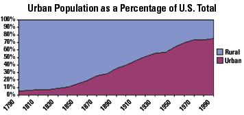
Figure 2. Source: Historical Statistics of the United States Colonial Times to 1970, Part 1, p. 11-12; Statistical Abstract of the United States 2000, p. 38.
American cities grew steadily throughout the first 75 years of nationhood but remained relatively small in geographic area and population. Most were located along transportation access points: at seaports, along navigable tidal and major inland rivers, along canals, and around the Great Lakes. The regional hinterlands beyond the cities produced raw commodities as a part of rural-based economies. Those commodities were then processed into durable goods in urban centers and redistributed in the area or transported to other regions where they were refined or even exported (Borchert, 1967). By the eve of the Civil War, however, the nature of urban development had begun to change. Cities were becoming centers of industry as access to local and regional natural resources improved and these resources were exploited. In addition, European social unrest led to a steady stream of immigrants arriving in the United States. These conditions were especially marked in New England and the Middle Atlantic States. The South and Midwest, by contrast, remained predominantly rural, although regional economies were linked to urban markets (Goldfield and Brownell, 1990, 95-102, 104-109). A few Western cities also appeared at this time, although few were significant on the national scene. In general, their economies tended to be based either on localized mineral wealth or on agriculture; a handful were Hispanic cultural centers (Starrs, 1995, 271-285).
The pace of urbanization quickened following the Civil War. Trains became the dominant transportation mode throughout the country, especially after 1870, when an economical way to mass-produce steel was introduced, allowing the construction of a vast rail network. Many cities were created as a result of railroad expansion, while others grew in size after becoming rail hubs. Industrialization also gained prominence, and by 1890 a national economy had been created. Natural resources from all parts of the country were used to fuel a rapidly expanding industrial Nation (Meyer, 1987, 321-345). Immigration, mostly from Europe, continued to bolster the burgeoning population. Drawn by factory jobs, many immigrants settled in cities. At this time, the majority of the Nation's urban population was still located in the Northeast and the Midwest (Goldfield and Brownell, 1990, 185-212). Cities in the South and West continued to grow but remained smaller in comparison. For example, in 1896, Miami had a mere 500 registered voters (Proctor, 1996, 269-270).
Changes in agricultural production increased the flow of people to the cities by the turn of the century. Regional specialization of specific commodities as a result of environmental conditions gave agricultural producers in some places an advantage over producers elsewhere. Farmers in areas where land was of marginal quality many times had to abandon agriculture and seek other sources of employment (Meyer, 1987, 326-334; Borchert, 1987, 103, 107). In the South, many African-Americans migrated to northern industrial cities to escape the growing failure of the postslavery sharecropping system that relied on monoculture cotton production (Clark, 1984, 145-146; Spinney, 2000, 167-170). Hispanic workers came to California and other Western States in increasing numbers as new irrigation projects made it possible to raise high-value but labor-intensive fruits and vegetables. Migrant field workers and their families often ended up living in small but growing urban areas throughout the region (Haverluk, 2000).
The old "downtown" city in America reached its zenith by the end of the First World War. The inner core of the city was the center of industrial management, production, and distribution. Such cities were predominantly densely populated, because most workers lived in multifamily dwellings near their sites of employment. Downtown landscapes were also being transformed as rising land prices and new technologies fostered the construction of high-rise buildings, or "skyscrapers." Suburbanization was initially limited to neighboring communities linked to city centers by railroads and electric streetcars. Modern highways were just making their first appearance (Muller, 1986). The U.S. Census of 1920 revealed that, for the first time, more Americans lived in urban than rural settings (Platt, 1996, 215).
Between 1929 and 1945, the United States underwent both the Great Depression and the Second World War. These events ultimately formed a watershed that separated an old form of urban dynamics from a new one that has evolved over the past 50 years. Some of the seeds of this change had already been sown, however, during the previous few decades. These included the rapid increase in automobile ownership in the 1920s and the creation of the modern mortgage loan in the 1930s. Consumer spending also was severely curtailed as a result of the Depression and World War II, first from hardship and then by forced austerity. This led to a buildup of personal savings that helped create the Nation's booming postwar economy into which the "baby boom" generation was born. Another factor that influenced this change in urban growth dynamics was the involvement by the Federal Government, in both the national economy and those of local communities, in committing massive amounts of money to fight the Depression and later, the war. Several metropolitan regions included in this booklet reflect growth stimulated by this World War II era activity. One noteworthy aspect of this involvement was the backing of long-term home mortgage loans by several agencies, such as the Federal Housing Administration and the Veterans Administration, following the war. Most of the housing units financed in this manner were built on the edge of the existing cities (Jackson, 1985, 190-218). In time, the selective funding of major public works and the creation of a military-industrial complex would come to favor some urban areas over others (Goldfield and Brownell, 1990, 323-341; Markusen and others, 1991, 8-25, 51-81). Examples in the booklet include the Boston, Orlando, Seattle, and Denver areas. A third significant influence on urban growth in the postwar era was the exposure that millions of Americans had gained to other parts of the country. During the 1930s, many people abandoned regions fraught with economic and environmental problems for new places that were thought to offer better opportunities and living conditions (Gregory, 1989, 3-25; Lewis, 1987, 433-436). Others who had been involved in the armed services were exposed to parts of the country that had greater appeal as future places of residence than their former communities (Mohl and Mormino, 1996, 424-425; Lewis, 1987, 433-436; Abbott, 1981, 37-41, 98-119). Orlando, Tampa, Phoenix, Las Vegas, and Denver are all examples of cities that had new military bases during World War II and offered different but attractive natural amenities to potential new residents.
A new form of urban growth gained prominence after the war: mass suburbanization around the older cities. Several factors fostered its spread. First, the development of an improved highway system allowed people to commute to their jobs in the cities from outside municipal boundaries. This trend began in the 1920s but accelerated greatly after the 1940s. The passage of the Federal Interstate Highway Act in the 1950s set the stage for large-scale, multilane roads that became a reality over the next 20 years. Other driving forces behind suburbanization were subtler. The Nation's growing middle class, comprised of both blue- and white-collar workers, now had the financial resources to buy single-family residences away from the high-density city center and could maintain their suburban lifestyle by commuting (Jackson, 1985, 231-245). The suburbs also represented a refuge for a growing number of Americans who longed for quieter, less hectic lives that were removed from the congestion, noise, pollution, multifamily residences, and high land prices typically found in the heart of the city. Many of the Nation's citizens were only a generation or two removed from farm or small-town living; the suburbs offered a means of bridging small-town and city life (Herbers, 1986, 91-101).
The Cold War era spurred the development of technology aimed at keeping the United States ahead of its perceived adversaries. Federal funding was channeled into research centers and the military-industrial complex. Communities that were home to major universities, aerospace and electronics industries, or defense installations benefited and grew as a result of these expenditures (Markusen and others, 1991, 32-50). Civic leaders sometimes pressured State officials to restructure existing universities - or to establish new ones, as happened in Las Vegas - in attempts to attract new industries to an area (Moehring, 2000, 223-227). Technological advancements, such as the widespread use of air conditioning, the growth of civil aviation, and increasingly inexpensive and plentiful electricity, encouraged the growth of cities in many parts of the country. Air conditioning, in particular, helped overcome environmental conditions in the Southeast and Southwest that were perceived drawbacks of year-round living in these regions (Mohl and Mormino, 1996, 433-435; Moehring, 2000, 22-23). Examples from the booklet include Orlando, Tampa-St. Petersburg, Phoenix, and Las Vegas.
The 1970 census revealed that, by this time, more of the Nation's urban population lived in the suburbs than in central cities. To a certain extent, suburbanization had been ongoing for nearly a century, but the trend had exploded during the post-World War II era. The suburbs had continued to grow during the 1960s, but by the end of the decade their relationship to the city centers had begun to change. The suburbs were no longer simply "bedroom communities" for commuting city workers. They were emerging as focal points for the retail and service sectors of the urban economy (Abbott, 1981, 57) (fig. 3).
The city centers remained strongholds of finance and corporate management. Manufacturing, on the other hand, was one of the leading segments of urban employment and was beginning to suffer major losses in the central cities. This was especially true for manufacturing's "heavy" industries. Numerous factors contributed to this decline, but perhaps the most influential was the fact that the city centers had lost their real or perceived competitive advantage. This deindustrialization accelerated throughout the next decade and continued into the 1980s. It left a changed urban landscape, both physically and functionally (Bluestone and Harrison, 1982, 25-48; Jakle and Wilson, 1992, 57-92). Pittsburgh is the most prominent example from the booklet.
Suburbanization did not strictly take the form of ever-widening concentric circles around a central city. Suburbs often developed along main highways in a linear fashion, linking pre-existing, outlying communities with the main city, as seen in the Boston and Sacramento pairs. In other cases, suburbanization progressed in leapfrog fashion, bypassing certain areas because of environmental conditions, ownership status, or zoning ordinances. A dramatic example of these conditions is seen in the Phoenix area (pages 28-29), where development grew around but not into the Salt River Pima-Maricopa Indian Reservation. Changes in land cover and land use that resulted from suburbanization differed across the Nation, depending on local conditions (Stansfield, 1998, 265). In some places, agricultural land offered the best possibilities for development (Matlack, 1997) (fig. 4). Alternatively or in other areas, marginal or nonagricultural land was the preferred choice for development, especially as time passed and other options became limited (Abler, Adams, and Borchert, 1976, 55). Development around lakes and forested islands can be seen in the Minneapolis-St. Paul and Seattle-Tacoma pages. As a result of all the above factors, the periphery of most metropolitan areas became a jumbled mosaic of different land covers and uses (Hart, 1991).
The 1970s witnessed the spread of another form of urban growth. In the minds of many, the suburbs had become havens of conformity, the site of nearly identical, ranch-style subdivisions and strip malls. The suburbs also started to manifest the same negative urban aspects of the older cities,
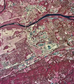
Figure 3. This 1987 USGS National Aerial Photography Program color-infrared photograph shows the King of Prussia, Pa., area, approximately 18 miles northwest of downtown Philadelphia. The intersections of three major highways (I-76, U.S. 422, and U.S. 202), seen in the center of the picture, formed the ideal location for new commercial, retail, and industrial development within the expanding metropolitan region.
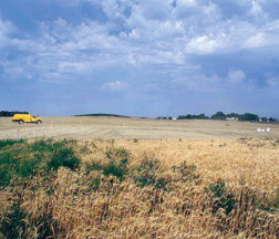
Figure 4. Former cropland, now residential "blanks", ready for new construction, Sioux Falls, S.Dak.
especially in those closest to them. Those people who wanted some of the urban advantages sought something other than the typical suburb. Many moved to large lots in surrounding rural areas and built single-family residences. These "ranchettes" or "acreages" typically ranged in size from 1 to 20 acres of land. The smaller ones were usually maintained as more traditional suburban house/yard/garden residences, while larger ones might have horses, ponds, woodlots, and even a few cattle. The latter did not function as farms, however, and actually fragmented surrounding land types, agricultural or otherwise. These "exurban" areas often had no recognized center, such as a major town, but instead were tied loosely to the region's primary metropolitan center (fig. 5) (Herbers, 1986, 201-208, 28-38; Theobald, Gossnell, and Riebsame, 1996).
The desire for and cost of new housing were also factors driving the spreading out of development around metropolitan regions. Land costs for new housing construction tended to be less expensive on the periphery of a metropolitan region. The increasing suburbanization of employment allowed people who desired new housing to live farther out from the urban core but still maintain a similar commuting pattern of the suburbs to city center that had dominated several decades earlier. Increasingly strict land use regulations in many of the post-Second World War suburban counties affected the cost of new housing by limiting the area available for development and driving individual unit costs higher. Adjacent counties that lacked such restrictive zoning many times absorbed the "spillover" of new development from more densely settled places (Morrill, 1992; Levinson, 1997a, 1997b).
A socioeconomic change that affected urban areas in the post-World War II era involved the elderly middle-class segment of society. These "retirees" were living longer and enjoying greater geographic mobility because they could take transfer payments, such as Social Security, company pensions, and rental or investment money, away from their home communities and spend it elsewhere (Mohl and Mormino, 1996, 423-424). Examples of cities in the booklet that grew because of in-migration of retirees include Orlando, Tampa-St. Petersburg, Phoenix, and Las Vegas. A second group, people with transferable skills primarily in the service sector of the economy, also enjoyed the freedom to move to regions that were perceived to be more desirable places to live, such as Denver, Reno, and Orlando. Areas with natural amenities, such as mild winters, scenic vistas, and opportunities for water-related recreational activities, attracted many people from both of these relatively mobile groups (Herbers, 1986, 102-110, 113-115, 116-126; Power, 1996, 34-45, 50-55). As a result, the "Sunbelt" of the South and West gained in population at the expense of the Northeast and Midwest. Many small- and medium-sized cities in the former regions were transformed by the influx of people and grew into major urban areas of national significance (fig. 6).
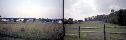
Figure 5. Exurban residences, (left) a rural subdivision in Culpeper County, Va. (right) a "hobby farm" in Chester County, Pa.
Figure 6.
The growth of many Sunbelt cities also benefited from laissez-faire attitudes of local governments in regard to urban planning. Civic boosterism had always been a means through which individual cities could gain status within regional and national urban hierarchies. But the explosive growth in the major Sunbelt metropolitan areas was greatly aided by "probusiness" and "progrowth" policies that were characterized by few regulations. The "boom" atmosphere that ensued resulted in perceived societal gains and losses (Kirby and Lynch, 1987; Luckingham, 1989, 147-158, 177-188, 221-229; Payne, 1994, 197-207, 274-283, 286-294, 325-333, 351-363). Examples from the booklet include Houston, Phoenix, and Denver.
The spatial distribution of employment also changed over recent decades. Suburbs initially became retail centers. But over time, manufacturing - in terms of both production and management - has become a growing presence in suburban and exurban areas. Most industries in these areas are typically described as being "light" or 'high-tech," and are much less site specific than their older, "heavy" industrial counterparts. Light industries are often located near transportation or information-based access points, such as along interstate highway "corridors" or near research facilities and/or major universities (Fulton, 1986) (fig. 7). The Atlanta and Raleigh-Durham areas are examples of cities having these conditions.
Many high-tech industries often cater to the needs and desires of their specialized workforce and are located in
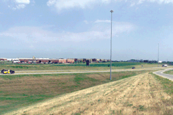
Figure 7. Modern manufacturing is often located near the edge of a city and near convenient interstate highway access.
places with abundant natural amenities. To a certain extent, industry management has also left the city center in favor of "corporate campuses" located near interstate highway interchanges or major airports (Garreau, 1991, 3-15). The municipalities of Schaumburg and Oak Brook from the Chicago pages are examples of such locations. Even smaller cities have seen an increase in industrial activities as the result of being within a day's drive of larger manufacturing centers that can supply the new "just-in-time," inventory-limited production systems (Rubenstein, 1990) (fig. 8).

Figure 8. The Toyota car assembly plant, located near Lexington, Ky., and built in the 1980s, is within a day's drive of the traditional core region of U.S. automobile manufacturing. Source: Toyota Motor Manufacturing, Kentucky, Inc.
Many of the processes described above are still ongoing within urban areas. Some cities continue to grow significantly, while various factors have slowed the growth of others. One reason that some parts of metropolitan areas have appeared to stop growing is that they have reached certain physical limits of geography. In the last several decades, many cities in the United States have experienced "infilling" of areas that were initially bypassed during past periods of urbanization. Several metropolitan regions have little remaining land available for development within what has been
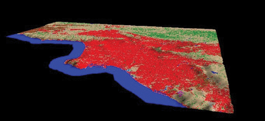
Figure 9. The Los Angeles basin was nearly fully urbanized by the early 1990s. This image was produced by combining the National Land Cover Dataset and the National Elevation Dataset for this area. Land cover classes have been collapsed into six categories: Red-developed, Tan-shrubland/grassland, Green-forest, Brown-agriculture, Magenta-transitional, and Blue-water. The elevation is exaggerated by a factor of 10, and the viewing position is at 6,000 meters above the Pacific Ocean to the south.
perceived as their traditional urban base, such as the Los Angeles basin or San Francisco Bay (Fishman, 1987, 178-181) (fig. 9).
The nonurbanized parts of these cities are preserved or restricted lands, such as regional parks, conservation or farmland trust areas, and military installations. Other nonurbanized lands are either prohibitively expensive or unsuitable for development, such as those with steep terrain or extensive wetlands. Suprametropolitan regions continue to expand, however, as greater Los Angeles spills out onto the Mojave Desert beyond the San Gabriel Mountains or San Francisco Bay urbanization pushes down numerous valleys in Contra Costa, Alameda, and Santa Clara Counties. The dynamics of American cities have not stopped; only their future evolution is yet to be determined.
Locator Map
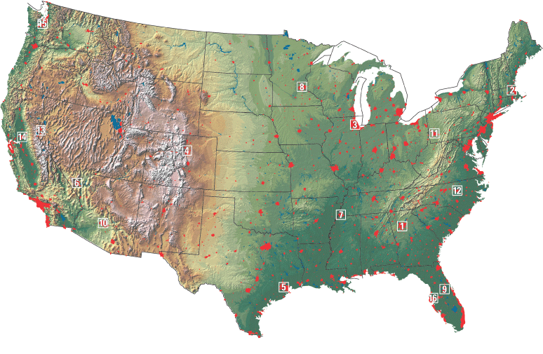
The 16 metropolitan areas selected for this study are shown as rectangular boxes on this locator map. The locator map is a combination of three layers of information. The base layer is the USGS National Elevation Dataset. It shows the topographic relief across the Nation. The red areas on the map represent urban places and were derived from two sources of land use/land cover information. One source is the USGS 1970s Geographic Information Retrieval and Analysis System (GIRAS), and the other is the Defense Meteorological Satellite Program- Linescan System.
- Atlanta, Georgia
- Boston, Massachusetts
- Chicago, Illinois
- Denver, Colorado
- Houston, Texas
- Las Vegas, Nevada
- Memphis, Tennessee
- Minneapolis-St. Paul, Minnesota
- Orlando, Florida
- Phoenix, Arizona
- Pittsburgh, Pennsylvania
- Raleigh-Durham, North Carolina
- Reno-Sparks, Nevada
- Sacramento, California
- Seattle-Tacoma, Washington
- Tampa-St. Petersburg, Florida
The metropolitan areas selected for this study usually include dozens of communities surrounding or in the general area of a dominant city. Although each is important to the entire metropolitan area, it would be impractical to label all of them for this booklet, and it would diminish the ability to visualize the growth of urban land between the two time periods. The following criteria were used for deciding what municipalities would be labeled: (1) The dominant city is not labeled unless there were two codominant cities involved, such as Minneapolis-St.Paul. The booklet has five regions where this is the case. (2) If a municipality is mentioned in the text as an example of urban change it is labeled. (3) Where an independent city noncontiguous to the dominant city is easily distinguishable, such as Davis and Woodland in the Sacramento pairs, it is labeled. This is not indicating that such cities are not within the urban hierarchical influence of the dominant city but that a substantial amount of undeveloped land is between them. (4) A municipality is labeled if it helps define the extent of the image map, such as Worcester, Mass., and Nashua, N. H., do for the Boston pairs. This helps give more of a geographical reference to the reader. Other information, such as county boundaries and water bodies, also help provide a needed reference.

- Atlanta, Georgia
- Boston, Massachusetts
- Chicago, Illinois
- Denver, Colorado
- Houston, Texas
- Las Vegas, Nevada
- Memphis, Tennessee
- Minneapolis-St. Paul, Minnesota
- Orlando, Florida
- Phoenix, Arizona
- Pittsburgh, Pennsylvania
- Raleigh-Durham, North Carolina
- Reno-Sparks, Nevada
- Sacramento, California
- Seattle-Tacoma, Washington
- Tampa-St. Petersburg, Florida
Ongoing Urban Dynamics Research
The USGS is committed to meeting the Nation's needs for current base geographic data and maps. This project demonstrates advances in technology that can be applied to the study of spatial-temporal dynamics related to human impacts on land transformation. This knowledge base and technology are being strengthened through The National Map, a consistent framework for geographic knowledge needed by the Nation. The building blocks of data and information used in Urban Dynamics research come from the wealth of archived USGS data and information. Additional information used in the research is acquired from sources such as the U.S. Census Bureau, Department of Agriculture, and National Aeronautics and Space Administration.
The change pair images in this booklet are just one of the many products of urban growth research associated with The National Map. Other products include maps and GIS projects with many layers of multiscale data and information associated with the physical changes that occur in urban areas over time. All of these products help to illustrate the changes, and from them many explanations can be derived about the causes of the changes. Ultimately, this information enhances America's ability to access, integrate, and apply geospatial data at global, national, and local scales.
Indepth Urban Dynamics research includes studies that are tracking the patterns, rates, and trends of urban change. In addition to physical changes in urban extent, correlations are being made with demographic, economic, and environmental information. In each study, the local history and description of human events in the region play a large role in understanding change. Computer models are being developed that can predict future urban growth patterns. Statistical analyses are being used to understand the causes and consequences of urban growth.
The USGS uses the geographic context of this research to provide comprehensive information needed in making land use management decisions, providing natural resource protection, and understanding significant social land use issues. A long-term goal of this research is to provide a nationally consistent description of current urban land surface and land use conditions for the Nation. A national study will highlight trends in urban change and provide a comparative analysis of diverse metropolitan areas within a national assessment of urban land use change. Another goal of this research is to inform policymakers and the public of likely impacts of urban growth. It is hoped that these activities will provide the baseline information and understanding to help resource managers and the American public understand and live comfortably with urban growth.
Acknowledgments
We would like to thank the following colleagues who helped throughout the process of creating this circular. They include Mark Barber, Elizabeth Ciganovich, Douglas Denne, William Draeger, John Hutchinson, Rebecca Johnson, David Kirtland, Christopher Laingen, Thomas Loveland, Lee McManus, Darrell Napton, Janice Nelson, Laurie Ortega, Bhaskar Ramachandran, June Thormodsgard, J. Nicholas Van Driel, and Ann Yaeger.
Bibliography
Abbott, C., 1981, The new urban America growth and politics in the sunbelt cities: Chapel Hill, N.C., University of North Carolina Press, 317 p.
Abler, R., Adams, J. S., and Borchert, J. R., 1976, The twin cities of St. Paul and Minneapolis: Cambridge, Mass., Ballinger Publishing Co., 69 p.
Acevedo, W., Foresman, T. W., and Buchanan, J. T., 1996, Origins and philosophy of building a temporal database to examine human transformation processes, in Proceedings ASPRS/ACSM annual convention and exhibition, Baltimore, Md., April 22-24, 1996: Bethesda, Md., American Society for Photogrammetry & Remote Sensing, v. 1, p. 148-161.
Allardice, D., Wiewel, W., and Wintermute, W., 1990, Chicago, Illinois: reaping the benefits of size and diversity, in Bingham, R. D., and Eberts, R. W., eds., Economic restructuring of the American Midwest: proceedings of the Midwest economic restructuring conference of the federal reserve bank of Cleveland: Boston, Kluwer Academic, p. 75-102.
Allen, F., 1996, Atlanta rising the invention of an international city 1946-1996: Atlanta, Ga., Longstreet Press, 290 p.
Anderson, J. B., 1990, Durham County: Durham, N.C., Duke University Press, 611 p.
Archer, K., 1997, The limits to the imagineered city: sociospatial polarization in Orlando: Economic Geography, v. 73, no. 3, p. 322-336.
Asano, T., 1987, Water quality management in California: Water International, v. 12, no. 3, p. 124-134.
Audirac, I., Shermyen, A. H., and Smith, M. T., 1990, Ideal urban form and visions of the good life Florida's growth management dilemma: Journal of the American Planning Association, v. 56, no. 4, p. 470-482.
Bailey, H. C., Deanovic, L., Reyes, E., Kimball, T., Larson, K., Cortright, K., Connor, V., and Hinton, D. E., 2000, Diazinon and chlorpyrifos in urban waterways in northern California, USA: Environmental Toxicology and Chemistry, v. 19, no. 1, p. 82-87.
Barnes, G., and Davis, G., 1999, Understanding urban travel demand problems, solutions, and the role of forecasting: Minneapolis, Minn., Center for Transportation Studies, University of Minnesota, 113 p.
Bathelt, H., 1991, Employment changes and input-output linkages in key technology industries: a comparative analysis: Regional Studies, v. 25, no. 1, p. 31-43.
Bederman, S. H., and Hartshorn, T. A., 1984, Quality of life in Georgia: the 1980 experience: Southeastern Geographer, v. 24, no. 2, p. 78-98.
Bell, C., Acevedo, W., and Buchanan, J. T., 1995, Dynamic mapping of urban regions: growth of the San Francisco-Sacramento region, in Proceedings Urban and Regional Information Systems Association, San Antonio, Tex.: Washington, D.C., Urban and Regional Information Systems Association, p. 723-734.
Bluestone, B., and Harrison, B., 1982, The deindustrialization of America: plant closings, community abandonment, and the dismantling of basic industry: New York, Basic Books, 323 p.
Borchert, J. R., 1987, America's northern heartland: Minneapolis, Minn., University of Minnesota Press, 250 p.
---, 1967, American metropolitan evolution: Geographical Review, v. 57, p. 301-332.
Braun, B. M., 1992, The economic contribution of conventions: the case of Orlando: Journal of Travel Research, v. 30, no. 3, p. 32-37.
Breckenfeld, G., 1977, Refilling the metropolitan doughnut, in The rise of the sunbelt cities: Beverly Hills, Calif., Sage Publications, p. 231-258.
Brindell, J. R., 1988, Balancing new development with conservation of wetlands in Florida: Urban Law and Policy, v. 9, p. 331-344.
Buchanan, J. E., ed., 1978, Phoenix a chronological & documentary history, 1865-1976: Dobbs Ferry, N.Y., Oceana Publications, Inc., 149 p.
Buchanan, J. T., Acevedo, W., and Zirbes, R., 2002, Decision support: a literature review and case studies in the central valley of California: U.S. Geological Survey Open-File Report 03-129, available at http://landcover.usgs.gov/urban/pubs.html.
Buisseret, D., 1990, Historic Illinois from the air: Chicago, University of Chicago Press, 232 p.
Bullamore, H. W., 1983, Non-residential land use in suburban Chicago: Geographical Perspectives, v. 51, p. 1-13.
Buni, A., and Rogers, A., 1984, Boston city on a hill an illustrated history: Woodland Hills, Calif., Windsor Publications, Inc., 240 p.
Chan, Y., and Ponder, R. J., 1979, The small package air freight industry in the United States: a review of the Federal Express experience: Transportation Research A, v. 13A, no. 4, p. 221-229.
Clark, S., Starr, J., Foresman, T. W., Prince, W., and Acevedo, W., 1996, Development of temporal transportation database for the analysis of urban development in the Baltimore-Washington region, in Proceedings ASPRS/ACSM annual convention and exhibition, Baltimore, Md., April 22-24, 1996: Bethesda, Md., American Society for Photogrammetry & Remote Sensing, v. 3, p. 77-88.
Clark, T. D., 1984, The greening of the South the recovery of land and forest: Lexington, Ky., University of Kentucky Press, 168 p.
Clarke, K. C., 1997, Land transition modeling with deltrarons, available at http://www.ncgia.ucsb. edu/conf/landuse97/, accessed June 19, 1999.
Clarke, K. C., and Gaydos, L. J., 1998, Loose-coupling a cellular automaton model and GIS: long term urban growth prediction for San Francisco and Washington/Baltimore: International Journal of Geographical Information Science, v. 12, no. 7, p. 699-714.
Colten, C. E., 1994, Chicago's waste lands: refuse disposal and urban growth, 1840-1990: Journal of Historical Geography, v. 20, no. 2, p. 124-142.
Conway, M., 1999, The great cities of the future: The Futurist, v. 33, no. 6, p. 28-33.
Crawford, J. S., Acevedo, W., Foresman, T. W., and Prince, W., 1996, Developing a temporal database of urban development for the Baltimore-Washington region, in Proceedings ASPRS/ACSM annual convention and exhibition, Baltimore, Md., April 22-24, 1996: Bethesda, Md., American Society for Photogrammetry & Remote Sensing, v. 3, p. 101-110.
Cronon, W., 1991, Nature's metropolis Chicago and the great west: New York, W.W. Norton & Company, 530 p.
Dameron, R. J., and Murphy, A. D., 1997, An international city too busy to hate? social and cultural change in Atlanta: 1970-1995: Urban Anthropology, v. 26, no. 1, p. 43-69.
Darkis, E. R., Jr., 1991, Durham, North Carolina city of medicine USA, 82 p.
Davies, R. O., 1999, Sagebrush and cities the emergence of the new Nevada, in Davies, R. O., ed., Maverick spirit building the new Nevada: Reno, Nev., University of Nevada Press, p. 3-11.
Dawson, D. B., 1997, Memphis new visions, new horizons: Memphis, Tenn., Towery Publishing, Inc., 463 p.
Debbage, K. G., 1979, Air transportation and urban-economic restructuring: competitive advantage in the US Carolinas: Journal of Air Transport Management, v. 5, p. 211-221.
Dietrich, W., 1999, How progress ate America: American Forests, v. 105, no. 3, p. 24-26.
Dorsett, L. W., and McCarthy, M., 1986, The queen city a history of Denver (2nd ed.): Boulder, Colo., Pruett Publishing Co., 382 p.
Dugan, J. M., 1981, Memphis cottons to PUD (urban development legislation, USA): Planning (ASPO), v. 47, no. 1, p. 19-22.
Dunn, H., 1985, Tampa a pictorial history: Norfolk, Va., The Donning Company, 224 p.
Elfin, J., and Wysong, J., 1990, Dynamics and planning policy: Geographical Review, v. 80, no. 2, p. 141-154.
Erickson, R. A., 1995, The location and growth of Pennsylvania's metropolitan areas, in Miller, E. W., ed., A geography of Pennsylvania: University Park, Pa., The Pennsylvania State University Press, p. 315-335.
---, 1986, Multinucleation in metropolitan economies: Annals of the Association of American Geographers, v. 76, no. 3, p. 331-346.
Feagin, J. R., 1985, The global context of metropolitan growth: Houston and the oil industry: American Journal of Sociology, v. 90, no. 6, p. 1204-1230.
---, 1985, The social costs of Houston's growth: a sunbelt boomtown reexamined: Journal of Urban and Regional Research, v. 9, no. 2, p. 164-185.
Fifield, B., 1996, Seeing Pittsburgh: Pittsburgh, Pa., University of Pittsburgh Press, 288 p.
Fisher, J. S., and Park, S. O., 1980, Locational dynamics of manufacturing in the Atlanta metropolitan region, 1968-1976: Southeastern Geographer, v. 20, no. 2, p. 100-119.
Fishman, R., 1987, Bourgeois utopias: the rise and fall of suburbia: New York, Basic Books, 241 p.
Fordham, J. W., 1993, Urban water planning- a western Nevada case study, in Hon, K., ed., Water management in the '90s a time for innovation proceedings of the 20th anniversary conference, Seattle, Wash.: New York, American Society of Civil Engineers, p. 16-19.
Fowler, D. D., Cargill, T. F., Dahl, A. J., Eadington, W. R., Ganzel, R., Siegel, R. L., Shahrani, M., Walker, J. L., Wilcox, A. R., and Wilcox, P. B., 1978, Final report sociopolitical, economic, and demographic factors relating to rapid urban growth in an arid region: a case study of the Reno, Nevada metropolitan area: Reno, Nev., Desert Research Institute, University of Nevada System, 74 p.
Fulton, W., 1999, Ring around the region: Planning (APA), v. 65, no. 3, p. 18-23.
---, 1986, Silicon strips: Planning (APA), v. 52, no. 5, p. 7-12.
Garreau, J., 1991, Edge city life on the new frontier: New York, Doubleday, 546 p.
Gladstone, D. L., 1998, Tourism urbanization in the United States: Urban Affairs Review, v. 34, no. 1, p. 3-25.
Goldfield, D. R., and Brownell, B. A., 1990, Urban America a history: Boston, Houghton Mifflin, 493 p.
Goodstein, P., 1999, Denver in our time a people's history of the modern mile high city volume one: big money in the big city: Denver, Colo., New Social Publications, 496 p.
---, 2000, Denver in our time a people's history of the modern mile high city volume two: DIA and other scams: Denver, Colo., New Social Publications, 552 p.
Greene, R. P., 1997, The farmland conversion process in a polynucleated metropolis: Landscape and Urban Planning, v. 36, no. 4, p. 291-300.
Gregory, J. N., 1989, American exodus the dust bowl migration and Okie culture in California: New York, Oxford University Press, 338 p.
Hagwood, J. J., 1976, Commitment to excellence: a history of the Sacramento district: Sacramento, Calif., U.S. Army Corps of Engineers Sacramento District, 289 p.
Hallinan, T. S., 1989, River city: right here in California?: Yearbook- Association of Pacific Coast Geographers, v. 51, p. 49-64.
Harkins, J. E., 1982, Metropolis of the American Nile Memphis and Shelby County an illustrated history: Woodland Hills, Calif., Windsor Publications, Inc., 223 p.
Hart, J. F., 1991, The perimetropolitan bow wave: Geographical Review, v. 81, no. 1, p. 35-51.
Haverluk, T. W., 2000, American metropolitan revolution: east meets west, paper presented at 31st annual South Dakota state geography convention, Brookings, S. Dak., Mar. 16-18, 2000.
Herbers, J., 1986, The new heartland: America's flight beyond the suburbs and how it's changing our future: New York, Times Books, 228 p.
Hester, D. J., 1999, Modeling Albuquerque's urban growth (case study: Isleta, New Mexico, 1:24,000-scale quadrangle), in U.S. Geological Survey Report 99-203, Middle Rio Grande basin study- proceedings of the third annual workshop, Albuquerque, N. Mex., Feb. 24-25, 1999, p. 8-12.
Hewings, G. J. D., Sonis, M., Guo, J., Israilevich, P. R., and Schindler, G., 1998, The hollowing out process in the Chicago economy, 1975-2011: Geographical Analysis, v. 30, no. 3, p. 217-233.
Hoppen, S. K., Clarke, C., Gaydos, L. J., and Acevedo, W., 1996, Communicating scientific findings to the general public, paper presented at the 3rd international conference/workshop integrating GIS and environmental modeling, Santa Fe, N. Mex., Jan. 21-25, 1996.
Howells, D. H., 1989, Historical account of public water supplies in North Carolina: Raleigh, N. C., The Water Resources Research Institute of the University of North Carolina, Report No. 244, 113 p.
Hudson, J. C., 1999, Contemporary world trade and the geography of straight lines, paper presented at 30th annual South Dakota state geography convention, Brookings, S. Dak., April 8-10, 1999.
Jackson, K. T., 1985, Crabgrass frontier the suburbanization of the United States: New York, Oxford University Press, 396 p.
Jakle, J. A., and Wilson, D., 1992, Derelict landscapes the wasting of America's built environment: Savage, Md., Rowman & Littlefield, Inc., 342 p.
Johansen, D., and Gates, C.M., 1967, Empire of the Columbia: a history of the Pacific northwest (2nd ed.): New York, Harper and Row, 654 p.
Johnston, R. A., Schwartz, S. I., and Tracy, S., 1984, Growth phasing and resistance to infill development in Sacramento County: Journal of the American Planning Association, v. 50, no. 4, p. 434-446.
Johnston, R. A., Sperling, D., DeLuchi, M. A., and Tracy, S., 1988, Politics and technical uncertainty in transportation investment analysis: Transportation Research A, v. 21A, no. 6, p. 459-475.
Judd, D. R., 1986, From cowtown to sunbelt city: boosterism and economic growth in Denver, in Fainstein, S. S., ed., Restructuring the city the political economy of urban redevelopment: White Plains, N.Y., Longman, Inc., p. 169-201.
Keller, M., 1999, A spot of green on a tour de sprawl: City Business-Minneapolis, v. 17, no. 7, p. 13.
Kirby, A., and Lynch, A. K., 1987, A ghost in the growth machine: the aftermath of rapid population growth in Houston: Urban Studies, v. 24, no. 587, p. 587-596.
Kirtland, D., Gaydos, L., Clarke, K., DeCola, L., Acevedo, W., and Bell, C., 1994, An analysis of human induced land transformations in San Francisco/ Sacramento area: World Resources Review, v. 6, no. 2, p. 206-217.
Kostyu, J. A., and Kostyu, F. A., 1978, Durham a pictorial history: Norfolk, Va., The Donning Company, 205 p.
Kramer, J., 1996, Integration of a GIS with a local scale self-modifying cellular automaton urban growth in southeastern Orange County, M.A. Thesis: New York, Hunter College, CUNY, 73 p.
Land, B., and Land, M., 1995, A short history of Reno: Reno, Nev., University of Nevada Press, 130 p.
Lankevich, G. J., ed., 1978, Atlanta a chronological & documentary history, 1813-1976: Dobbs Ferry, N.Y., Oceana Publications, Inc., 154 p.
---, 1974, Boston a chronological & documentary history, 1602-1970: Dobbs Ferry, N.Y., Oceana Publications, Inc., 152 p.
Lemmon, S. M., 1966, Raleigh- an example of the "new South"?: The North Carolina Historical Review, v. 43, no. 3, p. 261-285.
Levee, A., 1998, The hub is hot: Planning (APA), v. 64, no. 3, p. 4-11.
Levinson, D. M., 1997, Job and housing tenure and the journey to work: The Annals of Regional Science, v. 31, p. 451-471.
---, 1997, The limits to growth management: development regulation in Montgomery County, Maryland: Environment and Planning B: Planning and Design, v. 24, p. 689-707.
Lewis, P., 1987, America between the wars: the engineering of a new geography, in Mitchell, R. D., and Groves, P. A., eds., North America the historical geography of a changing continent: Totowa, N.J., Rowman & Littlefield, Inc., p. 410-437.
Lubove, R., 1996, Twentieth century Pittsburgh volume 2 the post-steel era: Pittsburgh, Pa., University of Pittsburgh Press, 413 p.
Luckingham, B., 1998, Discovering greater Phoenix an illustrated history: Carlsbad, Calif., Heritage Media Corporation, 343 p.
---, 1989, Phoenix the history of a southwestern metropolis: Tucson, Ariz., University of Arizona Press, 316 p.
Lyons, D., and Luker, B., Jr., 1998, Explaining the contemporary spatial structure of high-technology employment in Texas: Urban Geography, v. 19, no. 5, p. 431-458.
Markusen, A., 1991, The military-industrial divide: Environment and Planning D: Society and Space, v. 9, p. 391-416.
Markusen, A., Hall, P., Campbell, S., and Deitrick, S., 1991, The rise of the gunbelt the military remapping of industrial America: New York, Oxford University Press, 341 p.
Marston, E., 1994, Ripples grow when a dam dies: High Country News, Oct. 31, v. 26, no. 20.
Matlack, G. R., 1997, Land use and forest habitat distribution in the hinterland of a large city: Journal of Biogeography, v. 24, p. 297-307.
McComb, D. G., 1981, Houston: a history: Austin, Tex., University of Texas Press, 288 p.
McCormick, K., 1998, Home, home on the ranchette (last ditch efforts to keep Colorado's Front Range from looking like everyplace else): Planning (APA), v. 64, no. 2, p. 4-8.
McPherson, E. G., and Luttiger, N., 1998, From nature to nurture; the history of Sacramento's urban forest: Journal of Arboriculture, v. 24, no. 2, p. 72-88.
Meyer, D. R., 1987, The national integration of regional economies, 1860-1920, in Mitchell, R. D., and Groves, P. A., eds., North America the historical geography of a changing continent: Totowa, N.J., Rowman & Littlefield, Inc., p. 321-343.
Miller, C., and Johnson, D. R., 1990, The rise of urban Texas, in Miller, C., and Sanders, H. T., eds., Urban Texas politics and development: College Station, Tex., Texas A & M University Press, p. 3-29.
Miller, E. W., 1995, Pittsburgh: an urban region in transition, in Miller, E. W., ed., A geography of Pennsylvania: University Park, Pa., The Pennsylvania State University Press, p. 374-395.
Mims, J. E., and Mims, K. M., 1981, Sacramento: a pictorial history of California's capital: Virginia Beach, Va., The Donning Company, 207 p.
Mitchell, C. L. B., Perkins, W. J., and Gurtowski, T. M., 1999, Seattle solutions: Civil Engineering, v. 69, no. 12, p. 54-57.
Moehring, E. P., 2000, Resort city in the sunbelt Las Vegas 1930-2000 (2nd ed.): Reno, Nev., University of Nevada Press, 359 p.
Mohl, R. A., and Mormino, G. R., 1996, The big change in the sunshine state: a social history of modern Florida, in Gannon, M., ed., The new history of Florida: Gainesville, Fla., University of Florida Press, p. 418-447.
Mormino, G. R., 1983, Tampa: from hellhole to the good life, in Bernard, R. M., and Rice, B. R., eds., Sunbelt cities politics and growth since World War II: Austin, Tex., University of Texas Press, p. 138-161.
Morrill, R., 1992, Population redistribution within metropolitan regions in the 1980s: core, satellite, and exurban growth: Growth and Change, v. 23, no. 3, p. 277-302.
Morris, R. L., Devitt, D. A., Crites, A. M., Borden, G., and Allen, L. N., 1997, Urbanization and water conservation in Las Vegas valley, Nevada: Journal of Water Resources Planning and Management- ASCE, v. 123, no. 3, p. 189-195.
Mueller-Wille, C., 1990, Natural landscape amenities and suburban growth metropolitan Chicago, 1970-1980: Chicago, University of Chicago Press, 153 p.
Muller, P. O., 1986, Transportation and urban growth the shaping of the American metropolis: Focus, v. 36, no. 2, p. 8-17.
Murphy, A. B., 1986, Issues in the preservation and management of open space for recreational use in metropolitan Chicago: Environmental Review, v. 10, no. 1, p. 31-43.
Napton, D., 1990, Regional farmland protection: the Twin Cities experience: Journal of Soil and Water Conservation, v. 45, no. 4, p. 446-449.
Nash, G. D., 1985, The American west transformed: the impact of the Second World War: Bloomington, Ind., Indiana University Press, 304 p.
O'Connell, D. W., 1985, Florida's struggle for approval under the Coastal Zone Management Act: Natural Resources Journal, v. 25, no. 1, p. 61-72.
O'Connor, T. H., 1984, Bibles, brahmins, and bosses a short history of Boston (2nd ed.): Boston, Trustees of the Public Library of the City of Boston, 216 p.
Odell, K. A., and Weiman, D. F., 1998, Metropolitan development, regional financial centers, and the founding of the Fed in the lower South: Journal of Economic History, v. 58, no. 1, p. 103-125.
Payne, D., 1994, Big D triumphs and troubles of an American supercity in the 20th century: Dallas, Tex., Three Forks Press, 497 p.
Perkins, D., ed., 1994, The News & Observer's Raleigh a living history of North Carolina's capital: Winston-Salem, N.C., John F. Blair, Publisher, 202 p.
Platt, R. H., 1996, Land use and society geography, law, and public policy: Washington, D.C., Island Press, 507 p.
Power, T. M., 1996, Lost landscapes and failed economies: the search for a value of place: Washington, D.C., Island Press, 304 p.
Powell, W. S., 1989, North Carolina through four centuries: Chapel Hill, N.C., The University of North Carolina Press, 652 p.
Pred, A., 1984, Structuration, biography formation, and knowledge: observations on port growth during the late mercantile period: Environment and Planning D: Society and Space, v. 2, p. 251-275.
Proctor, S., 1996, Prelude to the new Florida, 1877-1919, in Gannon, M., ed., The new history of Florida: Gainesville, Fla., University of Florida Press, p. 266-286.
Pursell, D. E., Huston, C. R., and Davison, W. L., 1974, Economic base of the Mississippi-Arkansas-Tennessee Council of Governments/Memphis Delta Development District area: Memphis, Tenn., Bureau of Business and Economic Research, Memphis State University and the Mississippi-Arkansas-Tennessee Council of Governments, 211 p.
Roger, R., 1996, Orlando too much of a good thing: Planning (APA), v. 62, no. 3, p. 4-10.
Rose, D. C., 1990, Seattle city profile: Cities, v. 7, no. 4, p. 283-288.
Roth, D. C., and Ambrose, A., 1996, Metropolitan frontiers a short history of Atlanta: Atlanta, Ga., Longstreet Press, 226 p.
Rubenstein, J. M., 1990, Japanese motor vehicle production in the USA: where and why: Focus, v. 40, no. 2, p. 7-11.
Scherzer, K. A., 2000, Southern cities- how exceptional?: Journal of Urban History, v. 26, no. 5, p. 692-706.
Scwab, J., 1990, Two Forks stalled- for now: Planning (APA), v. 56, no. 4, p. 26-29.
Seabrook, C., 2000, Georgia, Florida, and Alabama far apart in water squabbles, Atlanta Journal-Constitution, February 28, 2000, C, p. 4.
---, 1998, The Chattahoochee River in peril: the water wars: Georgia, Alabama, and Florida are locked in a dispute over uses of the river that will affect everyday life for decades, Atlanta Journal-Constitution, October 5, 1998, E, p. 1.
Severson, T., 1973, Sacramento an illustrated history: 1839-1874: San Francisco, Calif., California Historical Society, 207 p.
Shankland, G., 1981, Boston- the unlikely city: Geographical Magazine, v. 53, no. 5, p. 323-327.
Spinney, R. G., 2000, City of big shoulders a history of Chicago: DeKalb, Ill., Northern Illinois University Press, 300 p.
Stansfield, C. A., Jr., 1998, A geography of New Jersey the city in the garden: New Brunswick, N.J., Rutgers University Press, 313 p.
Starrs, P. F., 1995, Conflict and change on the landscapes of the arid American west, in Castle, E. N., ed., The changing American countryside: Lawrence, Kans., University Press of Kansas, p. 271-285.
Starrs, P. F., and Wright, J. B., 1995, Great Basin growth and the withering of California's Pacific idyll: Geographical Review, v. 85, no. 4, p. 417-435.
Steinberg, P. E., and Clark, G. E., 1999, Troubled water? acquiescence, conflict, and the politics of place in watershed management: Political Geography, v. 18, no. 4, p. 477-508.
Streatfield, D. C., 1988, The emerald city a landscape of paradox: Landscape Architecture, v. 78, no. 6, p. 56-63.
Swanson, D. A., Malone, S. D., and Samora, B. A., 1992, Mount Rainier: a decade volcano: Eos, v. 73, no. 16, p. 177-192.
The Economist, 2000, Ashes to silicon Phoenix dreams of attracting high technology industries: v. 355, no. 8165, p. 30-31.
---, 1999, A hydra in the desert Phoenix's urban sprawl: v. 352, no. 8128, p. 26-27.
---, 1999, Right in the governor's back yard: v. 352, no. 8129, p. 26-28.
Theobald, D. M., Gosnell, H., and Riebsame, W. E., 1996, Land use and landscape change in the Colorado mountains II: a case study of the East River : Mountain Research and Development, v. 16, no. 4, p. 407-418.
Thompson, D., 1986, Nevada a history of change: Reno, Nev., Grace Dangberg Foundation, Inc., 232 p.
Thompson, G. L., 1998, Identifying gainers and losers from transit service change: a method applied to Sacramento: Journal of Planning Education and Research, v. 18, p. 125-136.
Toker, F., 1986, Pittsburgh, an urban portrait: Pittsburgh, Pa., University of Pittsburgh Press, 351 p.
U.S. Bureau of the Census, 1976, Historical statistics of the United States: colonial times to 1970, part 1: Washington, D.C., U.S. Government Publishing Office, 609 p.
---, 2000, Statistical abstract of the United States: 2000: Washington, D.C., U.S. Government Printing Office, 999 p.
Vexler, R. I., ed., 1977, Pittsburgh a chronological & documentary history 1682-1976: Dobbs Ferry, N.Y., Oceana Publications, Inc., 154 p.
Vickers, J., 1997, Raleigh city of oaks an illustrated history: Sun Valley, Calif., American Historical Press, 191 p.
Ward, G., 1996, The West an illustrated history: Boston, Little, Brown, and Company, 445 p.
Warren, J. R., 1997, King County and its emerald city: Seattle: Tarzana, Calif., American Historical Press, 294 p.
Waters, J., 1992, Setting the course for Twin Cities development: Minneapolis-St. Paul City Business, v. 10, no. 24, p. 15.
Weiss, J., 1989, Aurora: Denver's neighbor catches up: Planning (APA), v. 55, no. 1, p. 14-17.
Whitelegg, D., 2000, Keeping their eyes on the skies jet aviation, Delta Air Lines, and the growth of Atlanta: Journal of Transport History, v. 21, no. 1, p. 73-90.
