 U.S. Geological Survey
U.S. Geological Survey
U.S. Geological Survey
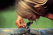 Safe drinking-water supplies are critical
to maintaining and preserving public health. Although the Nation's
drinking water is generally safe, natural and introduced contaminants in
water supplies throughout the country have adversely affected human health.
This new U.S. Geological Survey (USGS) initiative will provide information
on the vulnerability of water supplies to be used by water-supply and
regulatory agencies who must balance water-supply protection with the wise
use of public funds. Using the results of the initiative, they will be
better able to focus on the supplies most at risk and the variability of
contaminants of most concern, and so address the mandates of the Safe
Drinking Water Act. With its store of geologic, hydrologic, and land use
and land cover data and its network of information in every state, the USGS
can help to identify potential sources of contamination, delineate source
areas, determine the vulnerability of waters to potential contamination,
and evaluate strategies being used to protect source waters in light of the
scientific information available. Many recent and ongoing studies by the
USGS concern drinking-water issues. This fact sheet highlights four
particular studies begun under the Drinking Water Initiative.
Safe drinking-water supplies are critical
to maintaining and preserving public health. Although the Nation's
drinking water is generally safe, natural and introduced contaminants in
water supplies throughout the country have adversely affected human health.
This new U.S. Geological Survey (USGS) initiative will provide information
on the vulnerability of water supplies to be used by water-supply and
regulatory agencies who must balance water-supply protection with the wise
use of public funds. Using the results of the initiative, they will be
better able to focus on the supplies most at risk and the variability of
contaminants of most concern, and so address the mandates of the Safe
Drinking Water Act. With its store of geologic, hydrologic, and land use
and land cover data and its network of information in every state, the USGS
can help to identify potential sources of contamination, delineate source
areas, determine the vulnerability of waters to potential contamination,
and evaluate strategies being used to protect source waters in light of the
scientific information available. Many recent and ongoing studies by the
USGS concern drinking-water issues. This fact sheet highlights four
particular studies begun under the Drinking Water Initiative.
Arsenic in the Ground Water Supplies of Southeastern Michigan
Naturally occurring arsenic concentrations in ground water may exceed the drinking water standard in several counties in Michigan. Arsenic is one of the contaminants specifically mentioned in the 1996 Amendments to the Safe Drinking Water Act. There is widespread concern among local citizens and health officials regarding potential arsenic toxicity, partially because little is known about the areal and vertical distribution of high-arsenic ground water.
This study evaluates where the high concentrations are expected to occur by determining the areal and vertical distribution of arsenic-bearing minerals in the primary aquifer serving the affected counties. The study will also seek correlations between specific geochemical conditions and the release of arsenic from the minerals to the ground water. Products will include a database and maps of areas where high concentrations are expected, because of aquifer mineralogy and geochemical conditions.
Results of this study will provide valuable information to State and local health and environmental agencies to determine the need for an epidemiological study of exposed populations in southeastern Michigan. Results of this study may also identify specific actions that could be taken to avoid high concentrations of arsenic in ground water or to remediate contaminated water supplies. At a national scale, this and other studies will provide the U.S. Environmental Protection Agency (USEPA) with information on the current levels of arsenic in drinking waters in support of its new standard-setting process under the Safe Drinking Water Act.
For more information, contact:
USGS State Representative
6520 Mercantile Way
Lansing, MI 48911
telephone: 517-887-8943
E-mail: dc_mi@usgs.gov
Assessing the Quality and Vulnerability of Drinking Water in the San Joaquin Delta, California
Although most of California's precipitation falls north of the Sacramento-San Joaquin Delta during winter and spring, most of its water use occurs south of the delta during summer and fall. Thus the federal and state governments have built storage reservoirs north of the delta and canals south of the delta to deliver water where and when it is needed. These large-scale water transfers make it possible to support simultaneously a population of almost 30 million people and hundreds of thousands of acres of irrigated agriculture in a state that is mostly desert.
Disinfection byproducts (DBP) are formed when (largely natural) organic compounds react with chlorine during the normal disinfection process required for surface waters and some ground waters used for public water supply. The resulting compounds (for example, trihalomethanes) are potential carcinogens, and their removal is very expensive. Current land- and water-management practices in the delta lead to the addition of large amounts of natural organic carbon to delta waters. These natural organics, containing DBP precursors, are leached from the organic-rich peat soils that make up many of the islands in the delta and can adversely affect California's drinking water supply. The heavy rains in California in January 1997 have caused levees surrounding several of the islands to fail, flooding the islands. Release of dissolved organic carbon from the peat soils to the overlying flood waters may increase the amount of DBP precursors released into the water supply diverted from the delta.
Utilities would prefer to avoid DBP formation by using waters with low concentrations of the natural organic precursors, but the understanding of which compounds are most reactive and how to efficiently measure them is poor. This study will characterize the types of organic compounds acting as DBP precursors in the San Joaquin Delta and will search and test for an inexpensive method that will detect their presence. Such a method is of great interest to, and is a potentially large cost savings for, water utilities in the United States.
For more information, contact:
USGS State Representative
Placer Hall, 6000 J St.
Sacramento, CA 95819-6129
telephone: 916-278-3026
E-mail: dc_ca@usgs.gov
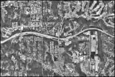
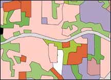
Computer images of the Atlanta area are analysed to produce digital land cover maps used to better understand the demands that changing land use places on water quantity and quality.
Vulnerability of Public Supply Wells in New Jersey to Chemical Contamination
New Jersey is the most densely populated state in the United States. About 85 percent of the 7.8 million inhabitants receive drinking water from public water systems. Significant contamination of surface and ground water supplies has occurred from both point and nonpoint sources.
Water quality contaminants of concern in New Jersey include natural radiological elements, volatile organic compounds (VOC), DBP, microbes, pesticides, and metals. These are of concern because of their potential carcinogenic health effects, the costs of monitoring and treatment, and a lack of understanding of their origins and transport. The radioactive elements (radium and uranium) are derived from natural materials in the soil. They are present in elevated concentrations in ground water because lime and fertilizer applied to agricultural fields create chemical conditions in the soil and aquifer that tend to make these elements dissolve and move with the water.
This study will determine the vulnerability of public water supply wells in the major aquifers of New Jersey to radiological activity and to contamination by VOC; evaluate the spatial variabilities in conditions that lead to the formation of DBP in public supply wells; and help State agencies designate wellhead protection areas by improving the methods for determining which areas contribute to wells. Results will allow water-supply agencies to tailor monitoring to the places and contaminants of most concern, determine the likelihood that standards will be exceeded, and point out locations for new wells with the lowest chance of contamination.
For more information, contact:
USGS State Representative
810 Bear Tavern Rd.
W. Trenton, NJ 08628
telephone: 609-771-3900
e-mail: dc_nj@usgs.gov
Quality of Drinking-Water Supply for Metropolitan Atlanta, Georgia
Atlanta's population increased by about 35 percent between 1980 and 1995, making it one of the fastest growing metropolitan areas in the country. Unlike many large cities that are located near the mouths of large rivers, metropolitan Atlanta is located near the headwaters of several major rivers. Nearly 100 percent of the drinking water for the metropolitan area is supplied by these rivers, providing drinking water for approximately 3 million people.
Historically, forested and sparsely developed watersheds upstream of Atlanta have provided a consistent source of high-quality water for drinking. However, as metropolitan Atlanta continues to grow into its supply watersheds, a critical issue for current and future development is the availability of sufficient high-quality water to meet the growing demand. There is every indication that as the metropolitan area becomes more developed, there will be a dramatic increase in contaminants associated with urban runoff and increased discharges from wastewater treatment facilities in the watersheds that supply drinking water.
Initially, a collaborative study by the USGS, Centers For Disease Control and Prevention (CDC), and USEPA will focus on the contaminant of most concern to water utilities and regulatory agencies, the protozoan Cryptosporidium. In 1993, Milwaukee, Wisconsin, experienced a Cryptosporidium outbreak that affected about 400,000 people. During that outbreak, some 100 deaths were attributed to the contaminated water. This study hopes to develop and field test sample collection and processing techniques that greatly improve the recovery of, and precision of analyses for, Cryptosporidium.
Because few data are now available on the occurrence and distribution of a broad group of chemicals and pathogens, such as Cryptosporidium, that are of concern to drinking-water suppliers, future USGS efforts are intended to provide an intensive assessment of water quality and to develop an interactive information base, including GIS coverages, that suppliers, managers, and other users could access.
For more information, contact:
USGS State Representative
3039 Amwiler Rd.
Atlanta, GA 30360-2824
telephone: 770-903-9100
e-mail: dc_ga@usgs.gov
For more information on the USGS Drinking Water Initiative contact:
Glenn Patterson
412 National Center
Reston, VA 20192
Telephone: 703-648-6876
e-mail: gpatter@usgs.gov
For information on other USGS products and services, call 1-888-ASK-USGS, e-mail: esicmail@usgs.gov, or fax 703-648-5548.
Receive information from the EARTHFAX fax-on-demand system, which is available 24 hours a day at 703-648-4888.
The address for the USGS home page is http://www.usgs.gov/