|
|
For more than 100 years, the U.S. Geological Survey (USGS) has provided the
information needed to manage the Nation's earth resources, to mitigate natural
hazards, and to understand the environment. In Washington, the USGS works
cooperatively with local, State, and other Federal agencies, as well as with
universities, to study earth science issues. |

|
|
Long time intervals between large-magnitude earthquakes in the Pacific Northwest
make predicting them particularly difficult. So that better predictions can be
made, the USGS, in cooperation with university researchers and the Geological
Survey of Canada, is using acoustic techniques to look at rock layers beneath
long, broad strips across the Pacific Northwest. For example, in September 1995,
the USGS and cooperating scientists recorded acoustic images of rocks beneath a
320-kilometer east/west transect in southwestern Washington. The scientists use
these transects to identify subsurface geologic structures that are associated
with earthquake activity. The presence or absence of such structures beneath
now-seismically quiet areas indicates the likelihood of future earthquakes. |
To help planners reduce the risk from large-magnitude earthquakes, the USGS made
computer simulations of the stresses that build up in rocks under the Pacific
Northwest. The simulations indicate that potential earthquakes in Washington
result from a complex balance of forces applied along a major fault offshore of
British Columbia and another fault offshore of Washington and Oregon. More
earthquake facts are on the World Wide Web and may be accessed at:
http://quake.wr.usgs.gov |
|
|
|
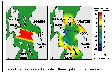
Earthquakes can generate tsunamis, which are great waves produced by the
sudden movement of the earth beneath the sea. To assess the hazards of
tsunamis, USGS researchers ran computer simulations of a tsunami generated
by a disturbance of the Seattle Fault, which is a historically active fault
that cuts across Puget Sound. In the simulations, the initial disturbance
produced a large tsunami that was about 23 feet high (fig. 1A). Four minutes later, the waves had
traveled far; a wave that was nearly 12 feet high lashed the Seattle
waterfront to the north while another headed south to the tip of Vashon
Island (fig. 1B). About 20 minutes later,
after the tsunami had traveled 20 miles south to Tacoma, it was about 6.6
feet high.
(Click on image for a larger version, 65K GIF)
|
|
Figure 1. Simulated tsunami. A, At the start of the
earthquake; B, Four minutes later. | |
Coupled with estimates of earthquake recurrence intervals and the extent and
recent activity of faults, these simulations can define the hazards of tsunamis
caused by landslides and shifting faults. |
|
Triggered by prehistoric earthquakes, landslides that lie on the floor of Lake
Washington and Puget Sound may indicate the threat of future landslides in the
Seattle-Tacoma area. By using acoustic techniques, the USGS, in cooperation with
the Washington State Department of Natural Resources (WDNR), mapped the
distribution, size, and shape of landslide deposits in Lake Washington and
Elliott and Commencement Bays in Puget Sound. This study revealed previously
unrecognized landslide deposits in the southern part of the Sound. Analyses are
used to assess the potential for damage to piers, bridges, and other structures
in and near water. In conjunction with this study, the USGS, in cooperation with
the U.S. Environmental Protection Agency (USEPA) and the National Oceanic and
Atmospheric Administration, recorded acoustic images at three Superfund sites
along the shore of Puget Sound to understand better the nature and extent of
contaminant migration from these sites to the offshore. The USEPA and the WDNR
are using the USGS data to remediate seafloor contaminated by hazardous waste.
http://walrus.wr.usgs.gov |
|
|
|
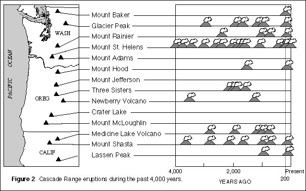
Seven volcanoes in the Cascade Range have erupted during the past few
hundred years (fig. 2), two of them during
this century. Future eruptions pose serious hazards to communities,
aviation, and interstate commerce in Washington, Oregon, and northern
California. In recent studies, the USGS has demonstrated that losses of
lives and property from future eruptions can be reduced substantially
through effective land-use planning and timely warnings of impending
volcanic activity. Therefore, the USGS, in cooperation with various
Federal, State, and county agencies, is studying the far-reaching effects
of past eruptions, monitoring for signs of renewed volcanic unrest,
developing new monitoring and predictive tools, and exchanging information
with concerned officials, agencies, and citizens to identify and mitigate
hazards from future eruptions in the Northwestern United States.
(Click on image for a larger version, 63K gif)
|
|
Figure 2. Cascade Range eruptions during the past
4,000 years. | |
In 1995, the USGS released updated volcano-hazard assessments for each of the
five Cascade volcanoes in Washington. A detailed geologic map of Mount Adams also
was released in 1995, and similar mapping projects are now underway at Mount
Baker, Mount Rainier, and Mount St. Helens. Mount Rainier is one of two U.S.
volcanoes designated for special study during the United Nations' International
Decade for Natural Disaster Reduction. As part of this effort, the USGS recently
released a quantitative assessment of debris-flow hazards at Mount Rainier. Other
work in progress includes a video on volcano hazards at Mount Rainier, exhibits,
teacher workshops, and Fact Sheets on the geology and hazard potential at Mount
Rainier.
http://vulcan.wr.usgs.gov |
|
|
|
Since 1977, annual streamflow in western Washington has decreased on average
about 14,000 cubic feet per second--nearly the equivalent of shutting off the
Skagit River. Annual precipitation also has decreased during the same period. The
USGS has linked these decreases, which are affecting the long-term water supply
of the area, to shifts in the climate of the Pacific Northwest.
Because the historical record of Pacific Northwest precipitation and streamflow
data, as well as Northern Hemisphere atmospheric and temperature data, has
indicated three distinguishable climate periods, the USGS divided the annual
records into three periods for analysis--the pre-1947 record, the base record from
1947 to 1976, and the post-1976 record. The analysis involved examining the means
and ratios of means of precipitation totals from 50 sites in western
Washington and streamflow averages from 112 sites in Washington, Oregon, and
Idaho.
|
The analysis revealed that mean precipitation and streamflow during the pre-1947
and the post-1976 periods were less than during the base period, although average
rainfall in March and April was actually greater in the post-1976 period than in
the wetter base period.
In the short run, the USGS analysis suggests that the water supply, though under
greater demand, is not being renewed as fast as it was two to four decades ago
because of the Pacific Northwest's currently drier and warmer climate. In the
long term, the analysis indicates that managing the Pacific Northwest's water
resources will require better understanding of the role of climate. |
|
|
|
Because water is in limited supply in many basins, withdrawals from streams are
allocated by permit from the Washington State Department of Ecology. With
streamflow fully allocated in some basins, ground-water development has
increased.
There are connections between a basin's ground water and its streams. Called
hydraulic continuity, this interaction between ground and surface waters has only
recently figured in the water-rights permitting process. As a result, permitted
withdrawals in some basins may exceed the total volume of water available for
development.
To assist the State in resolving the situation to the benefit of all water users,
the USGS began an education program to explain what happens between ground water
and surface water. The USGS, in cooperation with the Washington State Department
of Ecology, developed an effective training tool--a computer modeling program that
simulates the effects of well pumping on streamflow in a basin typical of the
Puget Sound Lowland.
|
"The USGS model demonstrates graphically how ground water and surface water
affect each other," said Linton L. Wildrick, hydrogeologist with the Washington
State Department of Ecology, "which helps us explain these concepts to the public
and the Legislature."
The USGS also is using the model in presentations to local water-resource
managers. |
|
|
|
The USGS's National Water-Quality Assessment (NAWQA) Program collects and
disseminates information about the quality of water resources in 60 selected
basins of the Nation, including 3 in Washington. Its purpose is to assess current
conditions and trends in water quality and to gain a better understanding of the
major factors that affect water quality. An important goal of the NAWQA Program
is to make relevant findings about water quality available to the public, as well
as to decisionmakers.
A NAWQA Program study carried out in the Yakima River Basin from 1986 to 1991
found high concentrations of the banned insecticide DDT in soil, streams, and
some fish. There is some evidence that improved agricultural practices, such as
drip and sprinkler irrigation, have reduced soil erosion, which is the main
source of DDT in streams.
A current NAWQA Program study focuses on the Central Columbia Plateau, which is
another area where water quality is heavily influenced by agricultural practices.
Nitrate concentrations exceed USEPA drinking water standards in 20 percent of
drinking water wells in the study area. High nitrate concentrations in ground
water are directly related to using large quantities of nitrogen fertilizers and
irrigation and may indicate that pesticides used along with fertilizers also are
in the ground water.
|
In 1994, the NAWQA Program began a study of the high-precipitation, densely
populated area of the Puget Sound Lowland, which contains water resources of
major economic and ecological importance. This study is looking at urban and
agricultural areas and focuses on water-quality issues such as occurrence and
concentration of volatile organic compounds, pesticides in streams and ground
water, and the health of in-stream habitats.
To ensure that results will be relevant, representatives of local, State, and
Federal agencies, universities, and private groups meet with USGS scientists
about twice a year to review study results and their implications and to advise
on plans for the future. One member, Phillip Crawford of Washington State
University Cooperative Extension, has commented that the focus on water quality
provided by the NAWQA Program produces a "teachable moment" that allows people
with historically diverse interests, including farmers, developers, and
environmental and conservation groups, to build consensus.
http://wwwdwatcm.wr.usgs.gov |
|
|
|
Among the most popular and versatile products of the USGS are its 1:24,000-scale
topographic maps (1 inch on the map represents 2,000 feet on the ground). These
maps depict natural and cultural features of the landscape, such as lakes and
streams, highways and railroads, boundaries, and geographic names. Washington is
covered by 1,456 maps at this scale. These maps have long been favorites with the
general public for outdoor uses, as well as with scientists and engineers for
technical applications.
Today, scientists and engineers depend on computerized base maps to provide
geographic context for their research and analyses. The USGS is working to ensure
the availability of accurate cartographic data to help address the Nation's
pressing resource and public safety issues, such as ground-water supply and
quality, natural hazards, and land and resource management.
|
The USGS is addressing the growing public- and private-sector demand for digital
data that describe transportation networks, hydrography, boundaries, Public Land
Surveys, and land elevation. To streamline production of these data and reduce
costs, the USGS, in cooperation with the WDNR and other Federal, State, and local
government agencies, is working on a program called Data '96. This program, which
uses private-sector contracting, acquires new data and combines them with data
contributed by cooperating agencies to complete digital data coverage for the
State of Washington by 1996. The data are used to manage Federal and State lands
better and to provide local and tribal governments with low-cost data.
A major benefit of the program is that it gives private industry and the public
access to the same digital data used by government agencies. Initially, the data
are being distributed by the WDNR to cooperating agencies. In the future, the
USGS expects to make the data available to Internet users. The State Geographic
Information Council was recently awarded a Federal grant to develop a pilot
digital catalog as a first step in making the data available on-line. |
|
The USGS, in cooperation with the WDNR, is working on a geologic map of Mount St.
Helens National Volcanic Monument. The map represents an important tool for
understanding the geologic setting of Mount St. Helens and provides an essential
framework for related detailed geologic mapping and analysis of the volcano and
its hazards by scientists of the USGS Cascades Volcano Observatory.
http://vulcan.wr.usgs.gov |
|
|
|
The USGS operates an Earth Science Information Center (ESIC) in Spokane. This
office specializes in providing earth science information on the Pacific
Northwest region to the public. The ESIC inventory includes USGS open-file
reports and topographic maps, land-use and land-cover data, and maps and reports
prepared by the Bureau of Land Management, the Defense Mapping Agency, and the
U.S. Fish and Wildlife Service's National Wetlands Inventory, for Washington,
Oregon, Idaho, and Montana. The office also conducts data-base searches and
places orders for digital cartographic data, aerial photography, and historical
maps. |
Other State ESIC affiliates for USGS products are the Washington State Library,
Information Services Division, in Olympia and the University of Washington,
Library Map Collection and Cartographic Information Services, in Seattle. |
|
|
|
The USGS, in cooperation with local, State, and other Federal agencies, collects
and disseminates such water data as streamflow, reservoir and lake stage,
ground-water level, water chemistry and water-quality, and climate. Much of the
data collected by the USGS in Washington and the Nation is stored in the National
Water Information System and are published annually.
The record-breaking Pacific Northwest floods of November 1995 illustrate the
relevance of current data collection and dissemination programs. The floods,
which were set off by rapid snowmelt during a series of rainstorms, caused the
Governor to declare a state of emergency in 14 Washington counties. Although road
closures made many of the USGS's 250 stream-gaging stations in the State
inaccessible, satellite telemetry and automated data-relay systems continued to
supply river-height data from stranded stations within minutes to emergency
management and information agencies. County emergency agencies, the U.S. Army
Corps of Engineers, and the National Weather Service depended on the USGS data to
develop flood forecasts, to manage reservoir levels, and to warn residents of
flooding in low-lying areas.
|
The USGS data bases cover about the last 100 years in Washington. These
historical data include flow for more than 1,100 discontinued streamflow-gaging
sites, intermittent records of flow for more than 5,000 streamflow-gaging sites,
and water-quality data for surface and ground waters at more than 10,000 sites.
These historical data constitute a long-term record of the quantity and quality
of the State's surface- and ground-water resources and help provide for the
orderly, informed development and management of Washington's water resources. |
|
|
|
The USGS is working to make water data more accessible to those who want it and
has begun to place data products on the World Wide Web. Through commercial
computer services, millions of Americans can now monitor river height and flow
for more than 70 streamflow-gaging sites in Washington. Historical streamflow
records also are online and more information is being added as the information
becomes available. The data products--and tracking the next big flood--can be
accessed through the USGS Washington District Home Page at:
http://wwwdwatcm.wr.usgs.gov |
(Click on image for a larger version, 81K JPEG)
|
|
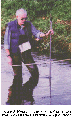
Figure 3. Measuring the flow in a Washington stream to
calibrate a streamflow-gaging station. |
|
|
|
|
The USGS Biological Resources Division (BRD, formerly the National Biological
Service) conducts research on issues critical to the use and management of
natural resources. The BRD's Northwest Biological Science Center (NBSC) in
Seattle undertakes projects throughout the Pacific Northwest. Research includes
studies on salmon populations, which are vitally important to local economies but
which are in severe decline in the Pacific Northwest; detection and diagnosis of
common and exotic fish diseases in the NBSC's unique disease containment
laboratory; research to understand interdependencies among fish, wildlife, and
their habitats; and pioneering the use of techniques, such as molecular biology,
to gauge ecosystem health prior to severe problems.
The NBSC's Columbia River Research Laboratory in Cook addresses salmon and other
fishery issues throughout the Columbia River Basin. Current research includes the
study of basic habitat requirements, movements, and survival of salmon, trout,
and white sturgeon in the Columbia and the Snake Rivers; the effects of dam
operations on the migration passage and survival of fish; and susceptibility of
young fish to predation, which results from conversion of the free-flowing river
to a series of reservoirs that contain introduced predators. |
The NBSC's Marrowstone Island Field Station in Nordland carries out research on
marine species and the saltwater life stages of salmon and steelhead. Projects at
the facility include characterizing the effects of stress and disease on salmon
and trout as they transform from a freshwater to a saltwater metabolism, the
effects of a spill of crude oil from a tanker ship on disease-free herring
spawned and grown at Marrowstone, and work toward first-time spawning of Pacific
Halibut in captivity, which may be a key to future conservation efforts for this
species.
The Washington Cooperative Fish and Wildlife Research Unit is housed at the
University of Washington, where Federal scientists teach, advise, and conduct
graduate-level programs. Research at the Unit focuses on the indirect impacts of
contaminants on wildlife, detection of pollution-mediated effects on various taxa
and communities (aquatic and terrestrial), the management of anadromous fish; and
population modeling of wildlife. |