This document is also available in pdf format:
![]() fs-046-99.pdf
fs-046-99.pdf
Great Salt Lake is important ecologically and economically. The lake and its wetlands provide critical wildlife habitat in an otherwise arid environment. The salts in the lake are a valuable economic resource and are extensively mined. The brine shrimp industry, which depends upon harvesting shrimp eggs, has recently experienced decreased harvests because of the decreasing salinity in water in the south part of the lake. The optimum salinity for the reproduction of brine shrimp eggs is believed to be between 12 and 18 percent. In the past several years, salinity has decreased to less than 9 percent in the south part and ranged from about 24 to 26 percent in the north part. To assist the State of Utah in making management decisions, the U.S. Geological Survey (USGS) developed a numerical model during the 1970's and 1980's for predicting the water and salt balance for variable inflow and differing causeway conveyance properties.
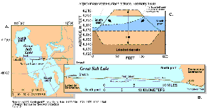
During 1957-59, a permeable rock-fill railroad causeway was constructed across Great Salt Lake (fig. 1A). Although two 15-foot-wide culverts and a 270-foot-wide breach allow some water to flow through, the causeway has acted as a partial dike by dividing the lake into north and southern parts (fig. 1B). The formerly free movement of brine, or water with a high concentration of dissolved salts, within the lake is restricted by the causeway and caused substantial changes to the hydrology, chemistry, and biology of the lake.
| Figure 1. A and B, locations of the rock-fill railroad causeway across Great Salt Lake, the culverts, and the breach, and C, brine flow through the causeway. |
Before construction of the causeway, the hydrologic and chemical characteristics of Great Salt Lake were typical of lakes that lack outlet streams. The lake water was thought to be well mixed and without temperature stratification. Salt was thought to condense and precipitate out of the water column throughout the entire lake when the lake volume was small enough for the saturation level for sodium chloride to be exceeded.
Since completion of the causeway, the factor that most affects the water and salt balance of Great Salt Lake is exchange of flow through the causeway. Because almost all surface-water inflow is to the lake's south part, the water surface there is at a higher altitude than that of the north part. Also, the water in the south part is less saline than that in the north part. Brine flows in both directions through the causeway fill, culverts, and breach because of the differences between the water-surface altitudes and the water density. Less dense brine from the south flows northward through the upper rocks and soil of the causeway, and more dense brine from the north flows southward through the lower rocks and soil of the causeway (fig. 1C). The southward flow sometimes causes a deep brine layer to form in the lake's southern part.
Structural modifications to the causeway in recent years have changed the conveyance properties of the causeway and thereby affected the salinity of both parts of the lake. The USGS is recalibrating the water and salt balance model to reflect these changes so that the model remains useful for lake management.
The Coal Resource Assessment shows the distribution and quality of coals in the southern Wasatch Plateau and the Kaiparowits Plateau. Research into the geologic controls on the occurrence and quality of the coal is being conducted on coals that may be available for development during the next few decades. Utah is a high-priority State for coal assessment. The quality of the coal is an important aspect of the assessment; during processing or use, its sulfur content and critical trace elements must meet the standards of the Clean Air Act of 1990. Coal Resource Assessment studies provide detailed stratigraphic cross sections with coal correlations, databases needed to conduct the assessments, coal-resource calculations, and basin and area geologic summaries.
The availability of environmentally acceptable and reliable energy sources at reasonable prices is an important issue for Federal, State, and local planners. The USGS and 13 cooperating State geological surveys have developed a systematic national effort to collect, analyze, and depict data that characterize the relation between restrictions to mining and the potential for development of the Nation's coal resources.
The Utah Geological Survey (UGS) began the first of several cooperative projects in the Wasatch Plateau and Book Cliffs area of Utah in 1996. A 296-square mile area was selected in the northern Wasatch Plateau area for State scientists to identify land-use, environmental, technologic, and geologic constraints, and, using geographic information system modeling, relate these restrictions to coalbed thickness and depth and mined-out areas. USGS and UGS geologists conferred on these coalbed correlations. The State then estimated the unrestricted amounts of coal that remain unmined and are available for development. In the northern Wasatch Plateau study area, this amounts to about 41 percent of the original coal resource. As the UGS scientists move on to the next area of study, the Book Cliffs, they will transfer their digital files of the northern Wasatch Plateau area to the USGS. USGS geologists and engineers will model mine plans, estimate future mining and washing losses, and estimate the amount of potential economically recoverable coal in the study area.
Preliminary studies indicate that the amount of coal in the northern Wasatch Plateau area that can be profitably mined is less than 20 percent of the total unmined coal in the area.
The Wasatch Plateau, one of the newest and, possibly, most productive coalbed methane areas in the United States, was chosen for study of the geologic and hydrologic controls of coalbed methane. The USGS, in cooperation with the UGS, River Gas, Inc., and Texaco, Inc., is studying the generation, migration, and production of coalbed methane; study results may be applicable to other areas. The controls of occurrence of coalbed methane are being evaluated through detailed geologic, geochemical, and engineering studies; three-dimensional water-flow models, which are important for methane production, are being constructed; and water disposal is being studied.
The USGS Oil and Gas Assessment Project is assessing the natural gas endowment of the U. S. Eighteen priority provinces, including the Uinta and Piceance areas, are estimated to contain 90-95 percent of the known and undiscovered natural gas resources of the U.S.
The project strategy in 1999 is to define petroleum systems and geologic assessment units in the Uinta-Piceance basin and assess the undiscovered natural gas resources, including conventional and continuous resources. This approach integrates all elements of the petroleum geology of a basin, including source rock characterization, hydrocarbon migration, timing of migration and structural evolution, sequence stratigraphy, and reservoir quality. The petroleum system will be subdivided into geologic units and assessed.
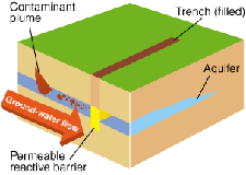
| Figure 2. A permeable reactive barrier. |
Permeable reactive barriers may provide economical and effective remediation techniques to clean up radionuclide-contaminated ground water that commonly is present near abandoned mill-tailing piles. The barriers are permanent, semipermanent, or replaceable units that are installed across the flow path of a contaminant plume. The barriers contain reactive material that degrades or immobilizes contaminants as ground water flows through them (fig. 2).
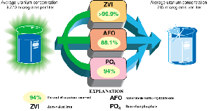
A cooperative demonstration project of the U.S. Environmental Protection Agency and the USGS is underway at the Fry Canyon site, which is a small area of uranium-bearing upgrader tailings in southeastern Utah. Up-grader tailings result from preconcentration of uranium ore before shipping it to a uranium mill for final processing. This site was selected in 1996 as a long-term field-demonstration site to assess the performance of selected barriers for removing uranium and other trace elements from ground water. Baseline uranium concentration in water from a well in the shallow colluvial aquifer ranged from 60 micrograms per liter (µg/L) to more than 17,000 µg/L in areas beneath the tailings. Three barriers were installed in August 1997. Reactive materials being used at the site are zero valent iron (ZVI), amorphous ferric oxyhydroxide (AFO), and bone char phosphate (PO4).
During the first year of sampling, more than 99.9 percent of the dissolved uranium was removed in the ZVI barrier, and more than 85 percent was removed in the AFO and PO4 barriers (fig. 3).
| Figure 3. The average 1-year decrease in uranium concentration after passing through the permeable reactive barriers at Fry Canyon. |
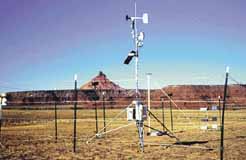
| Figure 4. Meteorological station in the Canyonlands area designed to monitor wind speed and direction, and soil moisture. |
In Utah, the USGS Global Change and Climate History Program focuses on developing records of past climate change and on learning how climate and human activities affect lakes, vegetation, and the land surface (fig. 4). Utah is particularly susceptible to the effects of natural and human-induced changes because it lies on an important climatic gradient, and climatic change can produce large changes in temperature, precipitation, and wind. Records of past change from such regions are important for understanding global climate change and for estimating the potential effects of future change on the local environment. Arid and semiarid regions make up much of Utah; such areas are among the most sensitive to changes in climate and land use. Information about how climate and human activities affect weathering, erosion, and deposition is essential for understanding the landscape's response to changes in climate and land use over time scales relevant for land-use decisions.
Records of past climate change are being derived from studies of Great Salt Lake and Bear Lake. Lake sediments contain rock fragments, minerals formed from lake water, and biologic remains, which provide a geologic record of the changing environment. Studies of present-day processes provide information used for interpreting data obtained from lake sediment cores. These studies are intended to provide baseline information for assessing the potential effects of lake-level changes on the urban area near Great Salt Lake and the effects of diversion of Bear River water into Bear Lake.
| Figure 5. Biological soil crust. |
The USGS is studying biological soil crusts (fig. 5) in arid ecosystems at the Canyonlands Field Station. The crusts, which are critical to ecosystem functioning in arid lands, are composed of mosses, lichens, and a group of bacteria called "cyanobacteria." The crusts are found throughout the world, particularly in arid and semiarid ecosystems such as those prevalent in the southwestern U.S.
The crusts affect soil stability, water infiltration, and soil fertility. For example, their sticky surfaces glue soil particles together, making soil aggregates larger. These larger particles are less susceptible than smaller particles to wind and water erosion. The roughened surface of the crusts also affects the moisture content of desert soils by slowing overland flow of precipitation, thereby increasing water infiltration into desert soils. Crustal organisms contribute nitrogen and organic matter to ecosystems.
Because of the significant contribution of biological crusts to ecosystem functioning, it is important to understand how environmental factors influence the distribution and abundance of different crustal components. Another facet of USGS research addresses disturbance to crusts. Cyanobacterial fibers are no match for the compressional stress of livestock hooves, off-road vehicle tires, or heavy foot traffic. Recovery of these crusts from such impacts in arid areas can take up to 250 years. Such disturbance may alter the role these organisms play in an ecosystem by influencing how they respond to their physical environment. For this reason, it also is important to understand the relation between environmental factors and crustal components in disturbed environments. With this information, land managers may be able to predict the consequences of different types and intensities of land use under different climatic regimes. USGS research also is directed at developing restoration techniques for ecosystems in which crusts have been destroyed or damaged.
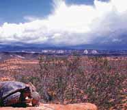
| Figure 6. A desert tortoise in the Red Cliffs Desert Reserve, north of St. George. |
To conserve biodiversity while allowing for economic growth in southwestern Utah, the Washington County Board of Commissioners began a Habitat Conservation Plan in 1996. USGS scientists are providing biological expertise and are working with the Utah Division of Wildlife Resources, the U.S. Bureau of Land Management (BLM), and Washington County. Providing adequate knowledge of the habitat for a viable population of the desert tortoise (fig. 6), a federally listed threatened species, is an objective of the plan. USGS researchers collect biological information on diet, nutrition, home range, habitat use, and distribution of the desert tortoise in Washington County in a long-term research project on the ecology of this species. This information has been used for designing and establishing a 60,000-acre desert reserve adjacent to the municipalities of St. George, Washington City, and Ivins. The USGS is developing a plan to monitor and analyze the distributions of plants and animals for regional management of multiple species.
The Single Edition Program is a mapping agreement with the U.S. Forest Service to revise, maintain, and distribute 1:24,000-scale topographic (7.5-minute quadrangle) maps of U.S. National Forest lands. About 500 maps cover the 7 National Forests in Utah, which comprise more than 8 million acres. The U.S. Forest Service maintains the maps, and the USGS prints and distributes them. The U.S. Forest Service Geospatial Service and Technology Center in Salt Lake City coordinates this program. Single edition maps, as well as standard USGS products, are available from map dealers, USGS Earth Science Information Centers, and National Forest Visitor Centers, or by ordering through the Internet.
|
The USGS office locations
|
USGS State Representative USGS Home Page: Reports and products: |