This document is also available in pdf format: ![]() fs-034-99.pdf
fs-034-99.pdf
 |
|
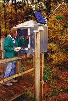
Figure 1. Satellite-linked stream gage on Crabtree Creek in Raleigh. |
For more than 100 years, the U.S. Geological Survey (USGS), in cooperation with the North Carolina Department of Environment and Natural Resources (NCDENR), the U.S. Army Corps of Engineers (USACE), and other cooperators, has provided streamflow data to the citizens of North Carolina. The World Wide Web now makes it possible to deliver more data faster. The North Carolina USGS Web site at http://nc.water.usgs.gov provides access to project information, publications, and near real-time streamflow and water-quality data. Monthly use of the Web site increased from 3,500 in July 1995 to more than 120,000 in July 1998, with as many as 12,000 requests for information automatically answered by Web information per day. Since 1995, the number of satellite-linked stream gages (fig. 1) and water-quality monitors in North Carolina has increased from 55 to 137. A special State appropriation made it possible to equip more than 30 additional sites for satellite data transmission during fiscal year 1999. Access to these data on the Web allows the USGS to serve a larger customer base, including river rafters, landowners, environmentalists, research scientists, and water managers.
The USGS is studying areas of storm-induced erosion along the highly developed coast of northern Dare County. Waves and currents move underlying sand, which causes beach buildup and erosion. These physical processes limit the ability of coastal managers to predict the evolution of beaches and coastlines.
Leading coastal scientists spent the 1997 summer and fall participating in SandyDuck 97, a field experiment designed to gather information about natural processes that cause beaches to change. SandyDuck was sponsored by the USGS, the USACE, and the Office of Naval Research and was hosted at the U.S. Army Engineer Waterways Experiment Station Field Research Facility. In addition to Federal researchers, scientists from more than 15 academic institutions participated in deploying more than 400 sensors to measure wind, waves, currents, water levels, sediment transport, and beach response.
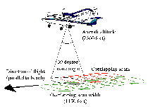 |
| Figure 2. The scanning pattern of NASA’s airborne topographic mapper. |
USGS researchers used a global positioning system to map the shoreline along a 30-mile stretch of barrier island coast, and used a scanning airborne laser system (LIDAR) to map beach topography (fig. 2) and high-precision sensors to measure wave and velocity fields and study the development of nearshore currents. The results of the daily mapping indicate that shoreline change is extremely rapid and highly variable along the barrier island coast. Further investigation is needed to determine why shoreline response varies dramatically along this apparently uniform reach of coastline. The LIDAR mapping, conducted in cooperation with the National Aeronautics and Space Administration (NASA) and the National Oceanic and Atmospheric Administration (NOAA), demonstrated that LIDAR systems are capable of accurately mapping beach and dune heights to within 15 centimeters. Sensors spanning the water column provided data to improve models of wave-breaking processes and the resulting flow structure, including commonly observed undertows.
 |
|
Figure 3. A northern red salamander. Length typically ranges from 3 to 7 inches. |
The Great Smoky Mountains National Park contains the greatest diversity of salamanders (fig. 3) in the United States. USGS scientists are conducting an amphibian monitoring and inventory project in this most visited of U.S. National Parks. The objective is to develop scientifically-based guidelines to track the status of 41 species of amphibians inhabiting the Park. Amphibian populations have declined in many places throughout the world, including National Parks, for unknown reasons.
A wide variety of habitats can be found in the Smokies, from the spruce-fir forests to the limestone caves in historic Cades Cove. Almost all of the Park’s habitats are included in the amphibian inventory, including habitats that are most sensitive and undergoing substantial change. The distribution information gathered from all of the surveys will be integrated into a geographically based dataset to show the effects of past human influence on the present distribution of key species of concern. These data are intended to provide the National Park Service with a reasonable evaluation of the Park’s amphibians and how they may be monitored in the coming years.
In a cooperative project with the USGS and the U.S. Bureau of the Census, the North Carolina Center for Geographic Information and Analysis (NCCGIA) headed a consortium of State agencies, including the North Carolina Department of Transportation and the North Carolina Department of Public Instruction, to develop a prototype for a geospatial data framework. Each participating agency helped to develop a framework data set for Moore County, and then assessed the use of the prototype data set with specific program applications. The results of this project will augment the National Spatial Data Infrastructure in North Carolina.
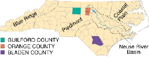
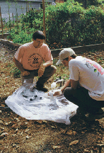
Increased growth and development in the Piedmont of North Carolina have made it necessary for county planners to rely on guidelines for the amount of development that can be supported by the local ground-water supply. To help develop these guidelines, the USGS is estimating ground-water recharge and sampling water from wells to analyze water quality in the fractured-rock aquifer systems of Guilford and Orange Counties (figs. 4 and 5). As a result of these studies, ground-water-flow contributions to streams can be calculated from long-term USGS streamflow records, and ground-water recharge within the county basins can be estimated. The median ground-water recharge for 27 basins in Guilford and Orange Counties ranges from 100 to 700 gallons per day per acre.
 |
 |
|
|
Figure 4. Physiographic boundaries, counties, and the Neuse River Basin of North Carolina. |
Figure 5. Sampling ground water for radon in Guilford County. |
The results of USGS water-quality sampling of 70 wells in Guilford County indicate that radon gas in well water differs with local geology. Radon is a radioactive gas that is reported to be a significant cause of cancer. Water from wells in younger igneous rocks in the northwest corner of the county have much more radon than water from wells in older metamorphic rocks in much of the rest of the county. Assessment of radon and other constituents, including nutrients and metals, is underway in Orange County.
Ground water is the major water source for residents and industries in the Coastal Plain of North Carolina. The USGS, in cooperation with the Lumber River Council of Governments, is studying the effects of ground-water withdrawals from several aquifers in the southern Coastal Plain. Ground-water withdrawals at Elizabethtown in Bladen County have caused decreased water levels in the Black Creek aquifer, a major supply aquifer for this area. The decreased water levels are estimated to be as much as 100 feet lower than the general water level in the surrounding area.
Researchers from the USGS are monitoring surface water, ground water, and biological aspects of water quality in the National Water-Quality Assessment (NAWQA) Program Albemarle-Pamlico study unit. The study unit encompasses about 28,000 square miles extending from the mountains through the Piedmont and into the Coastal Plain of southeastern Virginia and northeastern North Carolina. The study unit includes four major river systems (Chowan, Roanoke, Tar, and Neuse) that drain into the Albemarle and Pamlico Sounds. Some of the findings for this study unit include:
The USGS, in cooperation with the U.S. Environmental Protection Agency and the NCDENR, is evaluating nitrogen movement from the atmosphere through soil to ground water and then to receiving streams in the Neuse River Basin. The USGS is age-dating ground water by using organic and inorganic chemicals to test the validity of models designed to predict the fate and movement of nutrients through a watershed. A test site was selected near Farmville.
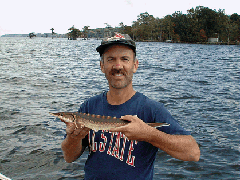
At the beginning of the 20th century, Atlantic sturgeon (fig. 7) were numerous in North Carolina waters and were prized for their valuable caviar. Little was known about their life cycles or numbers, however, and the population was quickly overfished. Atlantic sturgeon are long-lived and slow growing; females take more than 10 years to become sexually mature. The species is classified as threatened, and harvesting has been prohibited in North Carolina waters since 1991. Because of similar declines in most East Coast river systems, the Atlantic States Marine Fisheries Commission recently instituted a coastwide 40-year moratorium on harvesting the species.
 |
 |
|
|
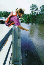
Figure 6. Collecting water samples in the Neuse River. |
Figure 7. Atlantic sturgeon returning to North Carolina. |
The USGS North Carolina Cooperative Fish and Wildlife Research Unit is studying Atlantic sturgeon population, growth, and habitat. Fish are caught and tagged, either with conventional tags or transmitters, and then released and tracked. USGS research results suggest that adult Atlantic sturgeon are very rare, but 1-year-old Atlantic sturgeon appear to be abundant in western Albemarle Sound near the mouth of the Roanoke River. Genetic studies conducted by collaborating researchers indicate that this is a distinct population from that of other East Coast rivers. The juvenile sturgeon in this area appear to be in good condition and growing rapidly, despite a habitat recently identified as having contaminated sediments and low levels of invertebrates commonly used by sturgeon for food. Further study of Atlantic sturgeon movements may help to develop management practices that aid in the recovery of the species.
 |
|
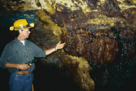
Figure 8. Stalactites, formed by iron oxide from acidic drainage, in the abandoned Fontana copper mine, Great Smoky Mountains National Park. |
The USGS is helping the National Park Service address issues related to natural acidic rock and acidic mine drainage associated with abandoned mines in the Park. Acid rock and acid mine drainage are associated with a shaly rock belt that extends from southeastern Tennessee into western North Carolina. These rocks host world-class copper deposits near Ducktown, Tenn., and less well-known deposits in the Great Smoky Mountains National Park in North Carolina. The host rocks contain pyrite (fool’s gold) and the related mineral pyrrhotite, natural acid producers that can adversely affect stream trout populations. Comprehensive geological and geochemical studies are providing information about the factors that control drainage and the effects of these acids on surrounding aquatic ecosystems.
The USGS and the North Carolina Geological Survey (NCGS) are cooperating to produce updated 1:24,000-scale topographic maps by using a new, streamlined revision process that creates a digital image from scanned paper maps, which allows them to be edited on the computer. These updated maps can be printed on demand and provide digital information on roads, power lines, water lines, and sewers. They have been especially useful for highlighting the rapid growth along the I-85 corridor and in the northeastern part of the State. This cooperative effort will update maps of urban areas on a 5-year cycle and rural areas on a 10-year cycle.
Statewide coverage of digital orthophoto quadrangles (DOQ’s), which function as a base for showing, generating, and modifying digital map data, is complete. DOQ’s can be used for mapping, resource and land-use planning, engineering, and differentiating between warm and cool bodies of water. This information is useful for assessing environmental impacts, planning emergency evacuation, analyzing floods and soil erosion, and analyzing ground-water and watersheds.
The National Aerial Photography Program was established in 1987 to coordinate aerial photography among Federal and State agencies. In cooperation with the State of North Carolina, the USGS produced 1998 color-infrared (CIR) aerial photographs as part of this program. Coverage for the State is 76-percent complete. CIR photographs are used for detecting vegetation types and healthy versus stressed crops, delineating wetlands, and monitoring agriculture. Individuals can purchase CIR photographs to use for hunting, hiking, and other recreation, as well as for discovering inherent qualities in familiar landscapes. The USGS and the NCCGIA are planning to produce 1999 CIR DOQ’s at the 1:12,000-scale to extend the development and maintenance of these key data.
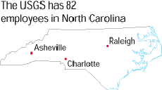
Since the passage of the National Geologic Mapping Act in 1992, the USGS National Cooperative Geologic Mapping Program has provided Federal funds to the NCGS and geology departments at the University of North Carolina at Chapel Hill and at Wilmington, North Carolina State University, and East Carolina University to produce geologic maps. These cooperative awards are matched by State and university funds. The maps show information about the hydrogeologic framework of selected areas, identify aggregate resources for expanding infrastructure needs, and aid in environmental assessment and planning. The most recent maps show the Asheville and Raleigh areas.
|
USGS office locations
|
USGS State Representative |
| AccessibilityFOIAPrivacyPolicies and Notices | |
 |
|