This document is also available in pdf format: ![]() fs-025-99.pdf
fs-025-99.pdf
In 1999, the U.S. Geological Survey (USGS) celebrated 100 years of surface-water data collection in Mississippi. Daily stage and discharge records for the Tombigbee River at Columbus date back to October 1899, marking the beginning of a program of data collection on Mississippi rivers and streams that would eventually involve partnerships with dozens of Federal, State, and local agencies. The data that are collected are stored in computerized local and national databases and disseminated to cooperators, educational institutions, private organizations, and the public in published reports and on the Internet.
The surface-water data-collection program in Mississippi involves the collection of continuous stage and discharge information at more than 100 sites and the collection of annual peak stage and discharge data for a network of nearly 100 additional sites. These data provide information needed to monitor and evaluate the flow characteristics of Mississippi streams. Data from each site in the continuous-record network are transmitted by satellite to the USGS office in Pearl, the information is processed, and then it is provided to the public and other water-resource agencies on the Internet at http://ms.water.usgs.gov. This Web page also provides historical data and other information about Mississippi streams.
 |
|
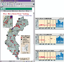
Figure 1. USGS and National Weather Service information for several sites on the Pearl River. |
In addition to providing the information needed by other agencies to monitor streamflow conditions and to manage reservoirs and waterways, the value of realtime telemetry is being demonstrated through the activation of the Pearl River Flood Tracking System (fig. 1). The Pearl River, which flows through Jackson and several other communities, including a part of Louisiana, has a well-documented history of severe floods, which have resulted in significant losses of lives and property. This basinwide system was developed in cooperation with Federal, State and local agencies, and it provides:
Hurricanes and tropical storms provide important opportunities for the USGS to assist other agencies involved in flood-response efforts. In the aftermath of Hurricane Georges, USGS crews collected and disseminated flood-flow, flood-profile, and storm-surge data important for assessing and mitigating damages.
In addition to monitoring flood conditions in the State, the USGS has compiled an extensive database of historical flood information for Mississippi streams. Bridge-site studies use this historical data with hydrologic analyses of the basins and hydraulic analyses of flooding potential to determine the flood-frequency and hydraulic characteristics of proposed highway bridges. This information provides the basis for the design of highways and drainage structures, and it is used by State and local agencies to guide floodplain management. The results of the bridge-site studies, which have been ongoing since 1951 and have generated reports for more than 2,100 sites, recently have been compiled into a geographic information system (GIS) database.
Ground water supplies 80 percent of all the freshwater used in Mississippi, and the demand for freshwater is expected to increase. The USGS, in cooperation with State and local agencies, investigates ground-water resources in Mississippi and maintains one of the Nation’s largest water-well databases, which includes information on lithology, water quality, well construction, and water levels.
The USGS is constructing a computer-based model of ground-water flow in the Mississippi River alluvial aquifer in northwestern Mississippi. The model will simulate the response of the aquifer to pumping as well as the recharge process and the interaction between the aquifer and the streams that are in contact with it. This aquifer provides water to one of the Nation’s intensively farmed and productive agricultural areas, and it is one of the most heavily pumped aquifers in the world.
The USGS also is updating the hardware, software, and operating instructions for ground-water flow models that have been developed and calibrated for the major aquifers in Mississippi in recent years. Simulations can then be conducted by the USGS to respond to public requests for water-resources information and to requests by other agencies involved in regulatory and management decisions.
The goal of the National Water-Quality Assessment Program is to describe the status and trends in the quality of a large part of the Nation’s water resources. Assessment of the Mississippi Embayment, which covers an area of about 49,800 square miles and includes parts of Arkansas, Kentucky, Louisiana, Mississippi, Missouri, and Tennessee, began in 1994. Since then, water samples have been collected at more than 50 streams and from 120 wells. Samples from these sites have been analyzed for the occurrence and distribution of common inorganic constituents, trace elements, nutrients, pesticides, and other organic compounds. The amounts of nutrients and suspended sediment transported by streams are being determined. Ecological characteristics of the streams, including algal, fish, and aquatic macro-invertebrate communities, are being evaluated as indicators of water quality. Organochlorine compounds and trace elements have been measured in fish tissue and bed sediment. More information and publications from this project can be found at http://ms.water.usgs.gov/misenawqa.
The Mississippi Delta Management Systems Evaluation Area Project is an interagency study to assess how agricultural activities affect the water resources in the Mississippi Delta and to increase the knowledge available for designing and evaluating management practices as components of farming systems. The study is being conducted at nine sites within three Delta oxbow-lake watersheds, where cotton production is the primary land use. Since 1995, more than 1,350 sediment, 460 pesticide, and 500 nutrient samples have been collected at sites with and without various management practices. Preliminary findings indicate that the quality of runoff has improved most at locations in the watershed where a combination of cultural and structural practices have been in place.
In support of the Demonstration Erosion Control Project, the USGS is monitoring suspended-sediment concentration and discharge in the upper Yazoo River Basin in north-central Mississippi. This multiagency project is designed to evaluate a broad range of erosion-control techniques in basins that have experienced decades of severe erosion. At the opposite end of the State, monitoring of coastal water quality is providing the water-level, temperature, and salinity data that are important to the efficient management of oyster and shrimp resources in the Mississippi Sound.
Wetland ecology, hydrology, mapping, and GIS technology are being used in an interagency study to identify wetland restoration areas in the lower Yazoo River Basin. This project uses a newly developed digital elevation model and hydrologic projections to examine flood frequencies and flood duration in areas that are classified as having optimal soil conditions and landscape characteristics for supporting wetlands.
The USGS is identifying the efficiency of instream structures used to protect stream habitat and native fish. Of particular interest is the dwindling population of Gulf Coast-strain walleye, which is native to the Mobile River Basin.
Waterway deepening, either by channelization or localized stream-bottom mining, can initiate a process known as "headcutting." Headcutting is a widespread cause of warmwater stream degradation. Headcutting also is associated with streambed widening, increased water velocity, loss of streamside vegetation from bank erosion and sloughing, increased sedimentation, and deteriorated water quality. In short, "headcutting" causes the habitat to change rapidly, usually to the detriment of fish communities.
 |
|
Figure 2. Installing a radiotransmitter in a walleye pike. The signals from these devices are used to track migrating fish. |
In an effort to curtail headcutting, the U.S. Army Corps of Engineers is evaluating the effectiveness of low-head rock dams or grade-control structures (GCS). Evaluations to date indicate that GCS may forestall headcutting. However, the effects of these structures on fish migration are not fully known. Therefore, USGS scientists have inserted radio transmitters in walleye to track the fish and evaluate their ability to migrate with GCS (fig. 2). Understanding the effects of the GCS on fish migration is especially important for Luxapalila Creek, one of the few remaining spawning streams of the State-listed Gulf Coast-strain walleye. Current research indicates that walleye can migrate past the GCS, but migration cannot be expected every year without modification of the GCS.
Successful upstream migration is only one component of sustaining this endangered population. Based on spawning requirements for other riverspawning walleye strains, suitable spawning and early life-stage habitat are present in Luxapalila Creek. However, after extensive sampling, no larval or juvenile walleye were found. Furthermore, adult walleye collected during 1997 and 1998 were found to be hatchery-produced offspring of Gulf Coast-strain walleye broodstock (fig. 3).
 |
|
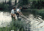
Figure 3. Electrofishing is used to sample fish communities and to collect fish for contamination studies in the streams and rivers in Mississippi. |
In Mississippi, scientists from the USGS study invasive and exotic species, fire ecology, bottomland hardwoods, and seagrasses. USGS research on exotic species includes exotic cogon grass at the Mississippi Sandhill Crane National Wildlife Refuge and invasion of woody plants into abandoned agriculture fields in the Yazoo National Wildlife Refuge. Fire research examines the effects of controlled burning on wet pine savanna habitat that is being restored for the endangered Mississippi sandhill crane, carnivorous plants, and other species at risk at the Crane Refuge.
Nationally, more than 80 percent of the historical southern forested wetlands has been lost, yet the remaining 20 percent still accounts for more than one-third of all wetlands in the lower 48 States. In an attempt to understand what the Nation has lost, the USGS is conducting genetic diversity research of bottomland hardwoods in the Hillside, Noxubee, Panther, and Yazoo National Wildlife Refuges. Finally, the USGS conducts seagrass mapping in areas of the Gulf Islands National Seashore.
Information about the location, quantity, and quality of the Nation’s coal resources to be consumed during the next 20 years will be needed by national and regional planners. In the National Coal Assessment Program, the USGS will work with the Mississippi Office of Geology to identify the location and quality of coal resources in the State, including coal that may be suitable for export, on public and private lands. The USGS is providing information to several Federal and State agencies that is intended to aid Mississippi and its industry in developing strategies to mitigate problems associated with acid rain and acidic mine drainage caused by the mining and burning of coal.
The USGS STATEMAP program is supporting detailed mapping by the Mississippi Office of Geology of north-central Mississippi, where economically significant deposits of lignite are being considered for power generation. Lignite production will require strip mining and construction of a power plant. This part of the State also is a recharge area for an important aquifer where protection of the ground-water supply is necessary.
The USGS has developed a strategy to help identify the 7.5-minute topographic maps that are in demand and need revision. This plan uses monthly sales of USGS maps as one criterion to determine the demand and set priorities in the map revision process. Those maps that need to be revised and are in high demand will be authorized. Other maps are selected for revision by cooperating agencies. The Mississippi Department of Environmental Quality, Office of Geology, selects the maps to be revised under a cost-sharing agreement with the USGS. The topographic map of the Jackson area has been revised, with the Mississippi Office of Geology providing onsite or field verification of buildings and other features and also accurate control for the contour revisions.
The work of the USGS in Mississippi is accomplished, in part, through cooperation with local, State, and other Federal agencies who share in the planning and financial support of the program. Local and State agencies that provided funding and services in support of water resources during 1995-2000 include the City of Jackson; the Harrison County Board of Supervisors; the Harrison County Development Commission; the Jackson County Board of Supervisors; the Jackson County Port Authority; the Mississippi Automated Resource Information Systems; the Mississippi Department of Agriculture and Commerce; the Mississippi Department of Environmental Quality, Office of Land and Water Resources, Office of Pollution Control, and Office of Geology; the Mississippi Department of Marine Resources; the Mississippi Department of Transportation; the Mississippi Emergency Management Agency; the Mississippi Rural Water Association; the Mississippi Soil and Water Conservation Commission; the Mississippi State Department of Health; the Pat Harrison Waterway District; the Pearl River Basin Development District; the Pearl River Valley Water Supply District; and the Yazoo Mississippi Delta Joint Water Management District. Federal agencies include the Bureau of Land Management; the Federal Emergency Management Agency; the U.S. Army Corps of Engineers, Mobile District and Vicksburg District; the U.S. Department of Agriculture, Natural Resources Conservation Service; the U.S. Environmental Protection Agency, Region IV and Region IX; and the U.S. Fish and Wildlife Service. Also, the USGS works with and provides support to the Mississippi Water Resources Research Institute, which conducts programs involving research, education, and information and technology transfer.
|
The office locations
|
USGS State Representative |