Prepared in cooperation with the Grand Canyon Monitoring and Research Center
By Robert H. Webb and Peter G. Griffiths
This document also is available in pdf format: ![]() FS–019–01.pdf (4MB)
FS–019–01.pdf (4MB)
(Requires Adobe
Acrobat Reader)
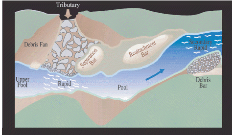
Coarse sediment (particles with an intermediate diameter > 64 mm) affects the primary components of the Colorado River ecosystem. The deposition of coarse sediment at tributary junctures builds large debris fans that constrict the river and form rapids (fig. 1). Debris fans, and the debris bars that develop below rapids, provide stable substrate for aquatic organisms, notably the alga Cladophora glomerata. The pool above and recirculating eddy below the debris fan effectively trap fine sediment for storage on the bed or in sand bars. Debris fans and debris bars form the fan-eddy complex that attracts humpback chub (Gila cypha), an endangered species. Monitoring the input of coarse sediment to the Colorado River ecosystem and its long-term redistribution by the river is critical to the understanding and management of these valued resources. This fact sheet presents an overview of methods for monitoring coarse sediment input and redistribution in Grand Canyon. These methods are discussed more thoroughly in Melis (1997), Melis and others (1994, 1997), and Webb and others (1999a, 1999b, 2000).
In small tributaries of the Colorado River between Powell and Mead reservoirs, coarse sediment is transported to the river almost exclusively by debris flow. While tributary streamflow deposits are well-sorted and typically have less than 3% coarse sediment by weight, debris-flow deposits are poorly sorted and contain 5 to 76% coarse sediment (Webb and others, 2000).
Debris flows can have an immediate and dramatic effect on the river corridor. Even a single small debris flow may significantly alter the topography and hydraulics of a debris fan and rapid in a matter of minutes. However, the Colorado River redistributes the coarse sediment introduced by debris flows almost immediately after deposition and during subsequent high flows. Before closure of Glen Canyon Dam, large floods on the river routinely removed all fine sediment and some coarse sediment from aggraded debris fans (a process called reworking ), transporting coarse sediment through the pool below the rapid and depositing it as debris bars (fig. 1). In the regulated river, floods of reduced magnitude do not have sufficient stream power to rework aggraded debris fans as thoroughly (Webb and others, 1999a, 1999b). Coarse particles that are entrained by these lower discharges may be deposited in the pools below rapids, potentially altering the eddy pattern and increasing the length of the rapid. As a result, debris fans and rapids may be aggrading over the long term.
The effective monitoring of coarse sediment requires both the short-term documentation of inputs by debris flow and the long-term evaluation of the redistribution of that sediment by the Colorado River. Both efforts involve measuring the volume and particle-size distribution of sediment delivered, as well as the effects of its redistribution on the morphology and hydraulics of the river channel. Monitoring debris flows at regular intervals will not only alert managers and researchers to sudden, potentially important changes to channel resources but also will add to an existing database designed to enable modeling of the interaction of coarse sediment and the Colorado River. The effective and efficient monitoring of channel change is highly dependent on current efforts by the Grand Canyon Monitoring and Research Center to develop a baseline topographic map of the entire river channel.
Most debris flows in Grand Canyon occur during the summer monsoon. Given that reworking can be substantial during high flows in the river, documenting new debris flows is best done annually between fall and early spring. Despite the large number of tributaries in Grand Canyon, debris flows are relatively infrequent; no more than 8 debris flows have been documented in any given year during the past decade (Melis and others, 1994; Webb and others, 2000). For purposes of comparison and maximizing information content, all monitoring should be done at river discharges that are as equivalent and as low as possible. Flow from the dam typically is low in the fall and early spring when heating and cooling demands for electricity are low.
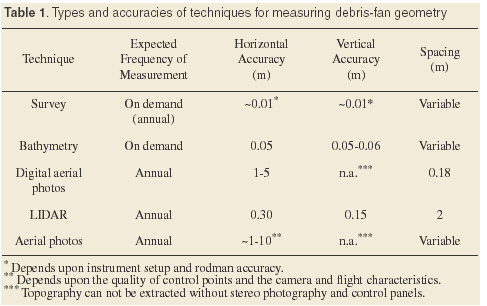
Several options exist for measuring debris-fan volume and area (Table 1). The most accurate measurement is obtained by combining direct survey of subaerial fan topography with multi-beam bathymetric measurements of the subaqueous debris fan. This is also the most expensive method, both in terms of field-work and data processing, and data for the topography of the debris fan before the debris flow are seldom available.
Remote-sensing techniques can overcomethese limitations at the expense of lower resolution and accuracy. The most promising technique uses image analysis of digital aerial photography. If high-gain digital aerial photography is taken over clear, non-turbulent water, the images can be analyzed to reveal subaqueous topography in shallow water. Digital topography combining subaerial and subaqueous features can be developed from stereo images. The technique is new (started in 2000) and cannot be used retrospectively for pre-debris flow conditions.
A slightly less accurate but time-saving alternative is the use of LIDAR (LIght Detection And Ranging), an airborne laser device which is expected to be flown annually for the entire river corridor beginning in 2001. The accuracy of LIDAR data as collected in Grand Canyon is considerably less than the diameter of most of the coarse particles being monitored. LIDAR topography must be combined with either field assessments or aerial photography to accurately map debris-fan boundaries and with multibeam bathymetric data to calculate a complete fan volume.
Aerial mapping photography, which typically is flown annually at a discharge of 8,000 ft3/s, is the least accurate but cheapest and most widely available technique. Aerial photography suitable for debris-fan monitoring has been flown at least annually since the mid-1980s, providing an excellent baseline of pre-flow fan conditions. Comparison of pre- and post-event photography greatly aids in delineating the boundaries of debris flows as well as reworking by the Colorado River (fig. 2). Standard aerial photographs must be digitized, georeferenced, and rectified before use, requiring the establishment of control points in the field. When pre-event topography is not available, fan volume can be calculated by multiplying the fan area measured from aerial photographs by an average thickness.
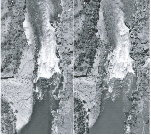 |
| Figure 2. Aerial photographs of the debris fan at Lava Falls Rapid. A , (March 24, 1996) Lava Falls Rapid was constricted by a 1995 debris flow from Prospect Canyon. B , (April 9, 1996) Reworking during the rising limb of the 1996 controlled flood removed 5,900 m 3 of the edge of the fan, increasing the width of the rapid by an average of 5 m. |
Particle-size distributions are best measured by combining point counts in the field with standard sieve analysis in the laboratory to capture the full range of particles found in debris flow deposits. Larger particles may be measured on site. Both unreworked deposits on fan surfaces and reworked deposits along distal fan edges are evaluated (fig. 3). Particle-size measurements should document suturing, or the interlocking of particles. Suturing is caused by there are rangement and wearing together of particles, and its suturing occurrence makes debris fans difficult to rework.
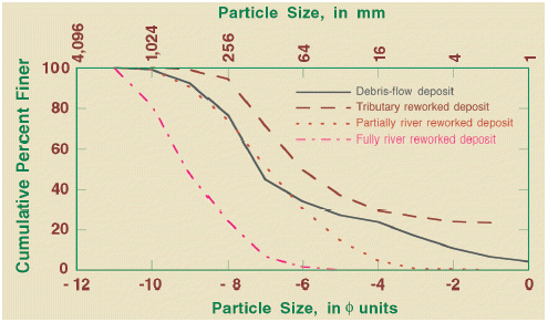 |
| Figure 3. Particle-size distributions reflecting reworking on distal margins of a recently aggraded debris fan at mile 127.6 in Grand Canyon. The curve for partially river reworked deposit is the result of releases from Glen Canyon Dam. The curve of fully river reworked deposit is for reworking under pre-dam conditions. |
Other measurements include surveying the water-surface fall through the rapid, which can be used to calculate stream power for a given discharge (fig.4). Surface velocity through the rapid can be measured by timing the passage of floats through the rapid. Other on-site measurements include documentation of floats through the rapid. Other on-site measurements include documentation of changes in hydraulic features such as the shifting of waves and holes, and the movement, appearance, or disappearance of rocks.
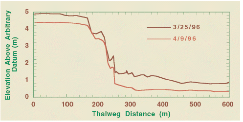 |
| Figure 4. Water-surface profiles through Lava Falls Rapid showing the effects of reworking by the March 1996 flood. |
Percent constriction of the river channel, a ratio of the average channel width through the rapid to the average channel width above and below the rapid (Webb and others, 1999a), is a useful measure of the impact of a debris flow on river channel morphology (fig. 5). For ease of measurement and consistency, measures of channel width are best obtained from georeferenced remote-sensing data, particularly aerial photographs. Aerial photography may also reveal qualitative changes in the hydraulics and navigability of rapids, reflecting underlying changes in the positions of boulders, and can be combined with field observations as a qualitative measure of channel change.
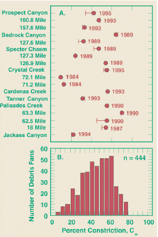 |
| Figure 5. Percent constrictions of debris fans. A. Error bar indicates change in constriction as a result of the 1996 flood with date of debris flow (Webb and others, 1999). B. All debris fans in Grand Canyon. |
Because debris bars typically are Because debris bars typically are unstable, much of the monitoring of these bars is best performed using remote sensing. This monitoring is most accurate when digital aerial photographs georeferenced by geographical positioning systems (GPS) are used because stable, longterm control points may be difficult to locate. Alternatively, LIDAR data of subaerial topography and multi-beam bathymetric data can be combined to give an important three-dimensional portrait of bar evolution over time. Particle-size distributions, and particularly lithologic counts, may be useful for assessing the stability and formation of debris bars.
Repeat monitoring of older fans could be performed at the same time as monitoring at recently aggraded debris fans, though additional monitoring should be done following the occurrence of atypically large reworking floods at other times of the year. Monitoring could start with an examination of new aerial photography and recalculation of debris-fan area, width of the reworked zone, and channel constriction. Because regulated floods do not overtop most fans but instead are eroded laterally, lack of change in any of these parameters indicates a stable fan where armoring is likely. Field work on these fans could be limited to annual point counts along the fan edge to evaluate the degree of armoring. Multi-year stability in particle-size distribution as well as fan area and channel constriction indicates a stable fan and monitoring could be suspended. However, any river discharge exceeding the maximum flood that has passed that fan to date would be cause to again monitor the debris fan for change. Conversely, change in any of these parameters, particularly after large floods, is suggestive of debris-fan reworking and additional field-work is necessary. New measures of fan volume and particle-size distribution are necessary to determine the fraction of deposit and classes of particles reworked by a given flood discharge at the site. Effects on the rapid are again measured by water-surface fall through the rapid, surface velocity, and calculations of stream power. New measures also reset the baseline for future measures of reworking. Changes in fan volume coupled with particle-size data can be used to estimate amount and sizes of coarse particles redistributed downstream to the pool or cobble bars.
Changes in debris fans can be used to assess the overall contributions of sand from small tributaries to the upper reaches of Grand Canyon, where sand bars are diminished. Sand bars may be covered by debris flows, eliminating their usefulness as camping beaches. Monitoring of sandbar size downstream from aggraded debris fans should be a consideration of any long-term monitoring plan for coarse sediment inputs. The volume of fine sediment in the upper pool could be monitored in concert with debris fans by multibeam bathymetric measurements. As reworking floods change the debris fan, fine sediment is liberated from the upper pool and is made available for storage downstream in sand bars.
Data collected from the monitoring of debris flows will have a number of important uses in the research and management the Colorado River ecosystem in Grand Canyon. Annual monitoring provides detailed, up-to-date information on changes in Grand Canyon rapids and eddies. Monitoring also provides an empirical measure of the quantity and particle-size distribution of sediment input to the Colorado River annually by debris flow as well as changes in substrate that is important to the aquatic food base. Aquatic plants use coarse particles as anchor points, and aquatic invertebrates use the spaces between coarse sediment as habitat. Identification of stable versus unstable deposits of coarse particles will aide in long-term assessments of aquatic productivity.
Debris-flow monitoring should be part of an adaptive management program, particularly with respect to changes in both aquatic and terrestrial habitat. Addressing the processes of debris-fan reworking and armoring makes possible the determination of how much and which size classes of coarse particles actually enter the river. This empirical information should be combined with sediment-transport models to estimate the zone of influence debris flows and debris-fan reworking have on downstream aquatic habitat.
The long-term effects of debris flows on the river corridor are also an important consideration, particularly in a river system with decreasing amounts of fine-sediment mantling the channel margins. Debris-flow inputs may form a significant part of fine-grained sediment inputs, as well as modifying channel geometry to enhance storage of fine-grained sediment. To date, these quantities have been estimated using a probability model of debris-flow occurrence coupled with generalized ranges of debris-flow volume and particle-size distribution (Webb and others, 2000). Building a database of debris flow input and reworking will permit the testing of these estimates as well as the development of a more realistic model of debris-flow inputs.
Melis, T.S., 1997, Geomorphology of debris flows and alluvial fans in Grand Canyon National Park and their influences on the Colorado River below Glen Canyon Dam, Arizona [Ph.D. Dissertation]: Tucson, University of Arizona, 495 p.
Melis, T.S., Webb, R.H., Griffiths, P.G, and Wise, T.J., 1994, Magnitude and frequency data for historic debris flows in Grand Canyon National Park and vicinity, Arizona: U.S. Geological Survey Water Resources Investigations Report 94-4214, 285 p.
Melis, T.S., Webb, R.H, and Griffiths, P.G., 1997, Debris flow in Grand Canyon National Park: peak discharges, flow transformations, and hydrographs, in Chen, C. (ed.),Debris-flow Hazards and Mitigation: Mechanics, prediction, and assessment, Proceedings of first International Conference: New York, American Society of Civil Engineers, p. 727-736.
Webb, R.H., Griffiths, P.G., Melis, T.S., Elliott, J.G., and Pizzuto, J.E., 1999a, Reworking of debris fans by the 1996 controlled flood in Grand Canyon, in Webb, R.H., Schmidt, J.C., Valdez, R.A., and Marzolf, G.R., The 1996 flood in Grand Canyon: Scientific experiment and management demonstration: Washington, D.C. American Geophysical Union, Geophysical Monograph, p. 37-51.
Webb, R.H., Melis, T.S., Griffiths, P.G., Elliott, J.G., Cerling, T.E., Poreda, R.J, Wise, T.W, and Pizzuto, J.E., 1999b, Lava Falls Rapid in Grand Canyon, Effects of late Holocene debris flows on the Colorado River: U.S. Geological Survey Professional Paper 1591, 90 p.
Webb, R.H., Griffiths, P.G., Melis, T.S., and Hartley, D.R., 2000, Sediment delivery by ungaged tributaries of the Colorado River in Grand Canyon, U.S. Geological Survey Water-Resources Investigations Report 00-4055, 67 p.
–Robert H. Webb, and Peter G. Griffiths