|
|
The U.S. Geological Survey (USGS) has served as
the Nation's principal collector, repository, and interpreter of
natural-science data for more than a century. In this capacity, the USGS
in Delaware works in partnership with municipal public-works departments,
public-health agencies, water and sanitation districts, other Federal
agencies, and State and county agencies. The USGS, as the Nation's
principal agency for natural science, provides the national perspective to
the many programs that are done in concert with these agencies.
|

|
|
|
|
The effect of human activity on water quality is an important and visible
environmental issue in the Nation. In response to this concern, the USGS
is conducting the National Water-Quality Assessment (NAWQA) Program, which
is a comprehensive assessment of water quality in 60 large regions across
the Nation. The purpose of this Program is to assess current water-quality
conditions and to investigate the effects of natural and human factors on
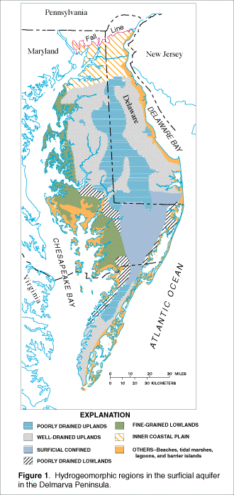
water quality. The Delmarva Peninsula is 1 of the 60 study areas included
in the NAWQA Program (fig. 1). The study is federally funded; however,
the USGS is working in partnership with Federal and State agencies that
also conduct research and that regulate water quality and manage resources.
(Larger Version, 98K GIF)
|
|
Figure 1. Hydrogeomorphic regions in the surficial
aquifer in the Delmarva Peninsula.
| |
Maintenance or improvement of ground- and surface-water quality are
important considerations in managing land-use practices on the peninsula.
The Delmarva Peninsula study has provided resource managers with useful
information on the relation of water-quality problems to agricultural and
residential land use. The study has shown that although high
concentrations of nitrate (greater than 10 milligrams per liter as
nitrogen), a known human-health hazard, are present in approximately 15
percent of the water samples from wells in the surficial aquifer, the
distribution of the nitrate concentrations differs regionally in relation
to changes in geology, soils, land use, and hydrologic flow patterns. High
nitrate concentrations in the surficial aquifer are more likely in upland
areas (fig. 1), where soils typically are well-drained and sandy and the
predominant land use is agriculture, than in other parts of the Peninsula.
High nitrate concentrations also are found in deep parts of the surficial
aquifer. Pesticides, which are widely present in water from shallow parts
of the surficial aquifer at concentrations below the U.S. Environmental
Protection Agency (USEPA) Health Advisory Limits, are not presently found
in deep parts of the aquifer.
The Delmarva Peninsula study also examined chemical patterns in ground and
surface water in small watersheds representing different landscapes on the
peninsula. Nitrate presently in the ground-water system will continue to
discharge to streams for at least the next few decades. Landscape
characteristics, such as the amount of forest cover and of poorly drained
soil and channel slope in a small watershed, were statistically related to
the major processes that affect water chemistry. |
|
|
|
|
|
The USGS is providing multidisciplinary technical assistance on
environmental issues at Dover Air Force Base. The USGS is assessing
ground-water flow in the surficial aquifer and determining whether or not
contaminants at several previous waste disposal sites are naturally
attenuating at rates that are adequate to prevent risk of offsite
contamination. This is being accomplished by drilling wells, sampling
ground water, and sampling soils in selected areas of the base; determining
the capacity of soils and aquifer materials to attenuate contaminants
naturally; and developing computer models to estimate ground-water flow and
pollutant transport in parts of the base. |
On the east side of Dover Air Force Base, disposal of fuel hydrocarbons and
degreasing solvents has resulted in contamination of the water-table
aquifer. Both the analysis of the ability of the aquifer materials to
attenuate the contaminants and the results of a geochemical model specific
for the site indicate that intrinsic remediation is sufficient for
decreasing contaminant concentrations to acceptable off-site levels. |
|
|
|
Understanding how ground water becomes contaminated can lead to informed
decisions on ways to protect drinking-water supplies. The USGS provides
technical assistance to the USEPA, Region III, Resource Conservation and
Recovery Act Division, with computerized simulations of ground-water flow
in the Delaware City area. To simulate ground-water flow in the area, the
USGS collects data, develops models of ground-water flow by means of a
geographic information system, and models possible ways to reduce
ground-water contamination caused by leaks from hazardous-waste sites in
the Delaware City area. These efforts will help the USEPA to develop
effective and economical plans to reduce contamination in this area. |
|
|
|
|
|
Floods and droughts can adversely affect the agricultural sector of the
State's economy as well as public safety. The USGS, in cooperation with
the Delaware Geological Survey (DGS), is improving the accuracy of
estimates of the severity of floods and droughts. State, county, and local
planning officials use the estimates to develop improved strategies for
water management and the design of infrastructure. |
The Delaware Department of Transportation (DelDOT), which provides
cooperative funds for studies of flood magnitude and frequency, and the
Delaware Department of Natural Resources and Environmental Control, which
cooperated with the USGS in a study of the frequency of low streamflows,
are two of the agencies that rely on the results of USGS studies. Results
of these studies are used by the DelDOT to reduce maintenance, repair, and
replacement costs for highway bridges and to improve the safety of
travelers during floods. State and local agencies use the results of the
low-streamflow study to allocate surface water and evaluate droughts,
thereby allowing appropriate water-supply decisions that ensure that the
water needs of the greatest number of people are met to the greatest
possible extent. Such contributions to public safety and well-being make
USGS reports valuable to the citizens of Delaware. |
|
|
|
|
|
The amount and quality of ground and surface water are vital to the
citizens of Delaware. The USGS operates a cooperative network of 14
streamflow-gaging stations, 6 tidal gages, and numerous water-level gaging
stations at wells to collect the data necessary to evaluate hydrologic
conditions. The locations of streamflow-gaging stations that were active
after 1980 are shown in figure 2.

(Larger Version, 65K GIF)
|
|
Figure 1. Locations of continuous streamflow-gaging
stations (solid triangles) in Delaware that were active after 1980.
| |
The detection of contamination and the prediction of contaminant movement
in ground water are important in the part of Delaware south of the
Chesapeake & Delaware Canal, where ground water supplies most freshwater
needs. Similarly, maintaining adequate supplies of surface water for
public consumption in northern Delaware and for fisheries and other
industries, the support of wildlife, and recreation are also important
issues. The USGS systematic data-collection program in Delaware received
cooperative support from the Delaware Geological Survey, the Delaware
Department of Natural Resources and Environment Control, the Delaware
Department of Transportation, the U.S. Environmental Protection Agency, the
U.S. Army Corps of Engineers, and other organizations. The USGS has an
important role in collecting data to address these issues. The
availability of up-to-date data on water levels and water quality and its
use by water-resource managers to help maintain the quantity and quality of
water needed for future use make the USGS systematic data-collection
program an integral part of water-resources management in Delaware.
Since 1950, the USGS has published reports at 5-year intervals on the
estimated use of water in the United States. Estimates of water use in
Delaware are combined with estimates by other States and water-resources
regions in accordance with methods and standards to meet regional and
national needs. |
|
|
|
The USGS Biological Resources Division (formerly the National
Biological Service) cooperates with other Federal and State agencies
to assess the type, quantity, health, and diversity of biological
resources in Delaware. The Delaware River, Delaware Bay, Chesapeake
Bay, and the Bombay Hook National Wildlife Refuge are current
locations for USGS biological research and study in Delaware. Study
topics include habitat restoration for fish and bird species;
assessing the effects of pesticides on aquatic life; mapping the
diversity of plant and animal communities through the use of satellite
imagery; gathering and analyzing quantitative information on
populations of breeding birds; and assessing the effects of
urbanization on fish in certain river reaches. |
|
|
|
|
|
The use of maps and digital cartographic data is widespread and demand for
this information continues to grow. The USGS strives to ensure the
availability of map data in graphic and digital form to the public through
timely and effective data-collection and revision procedures. The USGS
also fosters partnerships with other Federal and State agencies to improve
data collection and to maximize resource sharing. In 1995, under a
cooperative agreement with the DelDOT, the USGS assisted DelDOT's efforts
to prepare digital orthophotoquads (DOQ) that meet USGS technical standards
for image quality, resolution, and format. A DOQ is derived from an aerial
photograph that has been corrected for displacement caused by camera tilt
and terrain relief. A DOQ combines the image characteristics of a
photograph with the geometric qualities of a map. The DelDOT has provided
the USGS with 1:12,000-scale color infrared DOQ's covering the entire
State. The DOQ's are being archived by the USGS for distribution.
|
Among the most popular and versatile products of the USGS are its
1:24,000-scale topographic maps (1 inch on the map represents 2,000 feet on
the ground). These maps depict basic natural and cultural features of the
landscape, such as lakes and streams, highways and railroads, boundaries,
and geographic names. Delaware is covered by 57 maps at this scale. These
maps have long been favorites with the general public for outdoor uses, as
well as with scientists and engineers for technical applications. Digital
cartographic data, including boundaries, transportation, and hydrography
captured from the 1:24,000-scale map series are available statewide. The
USGS, in cooperation with the DGS, funded a 6-year statewide revision of
the 1:24,000-scale topographic maps covering Delaware. |
|
|
|
The Earth Science Information Centers (ESIC's) provide information to the
public about USGS programs, products, and technological developments. The
ESIC in Newark, Delaware, was established under a cooperative agreement
between the USGS and DGS and it is operated by the DGS. The ESIC provides
information on cartography, geography, digital data, remote sensing,
geology, geophysics, geochemistry, hydrology, geohydrology, aerial
photography, and land use. It is supported by the USGS with reference
materials, technical assistance, training, outreach activities, and access
to USGS data bases. |
|
|
|
Economic growth and development in Delaware depend in part on the
availability of local sources of minerals for use in industry,
manufacturing, and the maintenance and upgrading of the region's
infrastructure. The USGS, in conjunction with the State Geological Surveys
and resource agencies including the DGS, is inventorying known mineral
resources and assessing the potential for as-yet undiscovered mineral
resources, based on geological, geophysical, and geochemical studies.
Information in digital and paper form will assist Federal and State land
management agencies, regional planners, industry, and local governments in
ensuring adequate supplies of minerals at the lowest possible cost and
promoting sound management of the region's mineral resources. |
|
|
|
|
|
USGS activities in Delaware that are conducted in cooperation with other
agencies include water-resources data collection and interpretive studies
of water availability and quality. Projects have included assessment of
ground-water flow and quantity using ground-water-flow models of surficial,
confined, and fractured rock aquifer systems; assessments of water quality
with respect to brackish-water intrusion; studies of the effects of
different land uses on water quality in the surficial aquifer; studies of
the relation of wetlands to surface- and ground-water quality; and
documentation of floods. |
The DGS is the official point of contact for cooperative programs between
the USGS and the State of Delaware. The USGS cooperates through the DGS
with many State and local agencies throughout Delaware. For information on
geologic and hydrologic reports published by the State of Delaware and to
obtain USGS topographic mapping products (including maps, images, and
computerized data), contact the Delaware Geological Survey, DGS Building,
University of Delaware, Newark, Delaware 19716, (302) 831-2833, or e-mail
at dgs@mvx.udel.edu. |