|
|
Collecting, analyzing, and disseminating earth science information to solve
problems that concern the natural resources of the Nation has been an
integral part of the USGS mission since its creation in 1879. A long
tradition of providing accurate and impartial information to everyone
underscores our continued dedication to "Earth Science in the Public
Service."
|

|
|
|
|
Streamflow data are needed for water- rights issues (compacts, court
decrees, and adjudications), flood-plain management, bridge design, water
supply, reservoir operations, and flood warning. The U.S. Geological
Survey (USGS), in cooperation with State, local, and other Federal
agencies, operates 234 streamflow-gaging stations in Arizona and provides
data to those agencies, utilities, and irrigation districts that actively
manage the storage and release of water. At 110 of these stations,
streamflow data are relayed by satellite (fig. 1) to a USGS computer in
Tucson and can be accessed by agencies in near real time for immediate
water-management decisions. The importance of the streamflow network was
demonstrated during the floods of January and February 1993 when streamflow
data from satellite telemetry were used by the Bureau of Reclamation (BOR)
and the Salt River Project (SRP) to manage storage and releases from the
reservoir systems along the Verde, the Salt, and the Gila Rivers.
|

(Click on image for a larger version, 50K JPEG)
|
|
Figure 1. Streamflow data-collection network. |
The USGS also collects data on minerals in Arizona. As a result of the
North American Free Trade Agreement, the USGS is developing cooperative
projects with Mexican counterparts to inventory and assess the quantity
and quality of mineral resources in the border area between Arizona and
Sonora, Mexico. This information is vital to land-management agencies,
regional planners, industries, and local governments that are responsible
for ensuring adequate mineral supplies.
|
|
|
|
Among the most popular and versatile products of the USGS are its
1:24,000-scale topographic maps (1 inch on the map represents 2,000 feet on
the ground). These maps depict basic natural and cultural features of the
landscape, such as lakes and streams, highways and railroads, boundaries,
and geographic names. Contour lines are used to depict the elevation and
shape of terrain. Arizona is covered by 1,968 maps at this scale, which
are useful for civil engineering, land-use planning, natural-resource
monitoring, and other technical applications. These maps have long been
favorites with the general public for outdoor uses, including hiking,
camping, exploring, and back-country hunting and fishing
expeditions.
|
|
|
|
|
|
In 1993, the USGS initiated a regional assessment of water quality in
central Arizona and northern Mexico. The purpose of the study is to
describe the status and trends in the quality of Arizona's major ground-
and surface-water resources (fig. 2) and to provide a better understanding
of the factors that affect water quality. The study area encompasses
34,700 square miles and includes a population of more than 3.1 million
people. The Program focuses on pesticides; nutrients, such as nitrates and
phosphates; volatile organic compounds; and aquatic ecology. Data are
being collected during the sampling phase from 1996 to 1998. |

(Click on image for a larger version, 50K JPEG)
|
|
Figure 2. Water-quality data-collection sites in Arizona.
|
|
|
|
|
|
|
In Grand Canyon National Park (fig. 3)
, operations of Glen Canyon Dam are
affecting recreational use of sand bars, changing riverine habitat for
plants and animals, and threatening a loss of archeological sites. The dam
has reduced the sediment supply to the Grand Canyon and decreased the
magnitude and frequency of floods that rebuild sand bars and transport
coarse debris. Understanding the effects of regulated flows on the
physical and biological systems along the Colorado River downstream from
the dam is the objective of a series of studies which began in 1982. The
studies, being conducted by or in cooperation with contractors,
universities, federal and state agencies, and Indian tribes, will provide
managers with a scientific basis for optimizing dam operations. |

(Click on image for a larger version, 50K JPEG)
|
|
Figure 3. Selected project areas. |
|
USGS studies show that low, moderately fluctuating flows through the dam
transport sand, brought to the canyon by tributaries downstream from the
dam, through the canyon along the channel bed. These low flows also allow
the build up of coarse debris that can affect the navigability of the
river. A test of controlled flood releases in the spring of 1996 showed
that enough sand is available from tributaries downstream from the dam to
rebuild sand bars, and that controlled floods can redistribute
recently-deposited coarse debris. The USGS is developing a series of
computer models to describe the deposition and erosion processes in the
Grand Canyon. These models will make it possible to simulate different
operational plans for the dam, and to predict their effects on sediment
resources in the canyon.
|
|
|
|
|
|
The San Pedro River in southeastern Arizona has perennial flow along much
of its length, from its headwaters near Cananea in Sonora, Mexico, to its
confluence with the Gila River at Winkleman. The San Pedro River includes
the site of the first National Riparian Conservation Area established by
the Bureau of Land Management (BLM). The area (fig. 3)is habitat for
diverse plants and animals, some of which are threatened or endangered; a
vital flyway for migrating birds; and the basis of the substantial
ecotourism industry in the area.
Ground-water withdrawals associated with population growth in Cochise
County and the city of Sierra Vista may decrease streamflow in the upper
San Pedro River and, thus, adversely affect the riparian corridor. These
withdrawals also may complicate the adjudication of water rights that
involve Native American Tribes. Subsidence and the development of earth
fissures are other features that may result from lowering of the water
table.
USGS geologists, hydrologists, and geophysicists are working to determine
the three-dimensional subsurface shape of the San Pedro Basin, to estimate
the character and distribution of the basin-fill sediments, and to obtain
objective data on the amount of ground water stored in basin aquifers and
on the connection between these aquifers and the river. The geological
and geophysical studies are currently (1996) focused in the upper San
Pedro Valley between Cananea and Benson. |
To date, geologic mapping is being conducted north of Cananea. New
geophysical data in Arizona have defined two northwest-trending subbasins
beneath the upper San Pedro Valley. The Palominas Subbasin is about 2,300
meters deep, and the Huachuca City Subbasin is about 1,100 meters deep.
They are separated by an east-trending buried ridge beneath Sierra Vista.
These data obtained in the USGS investigations are essential to all the
parties involved in discussions on water usage in the San Pedro Valley,
including the cooperating agencies-the BLM, the BOR, the U.S. Army, the
Arizona Department of Water Resources, the University of Arizona, the
Arizona Geological Survey, the San Pedro Technical Advisory Committee, The
Nature Conservancy, and Cochise County.
|
|
|
|
|
|
The USGS has started a 1:24,000-scale series mapping revision/replacement
project for the 41 maps that cover Phoenix and the surrounding area.
Existing maps are being updated to reflect recent urban growth and ground
subsidence. The project is part of the USGS program for replacement
mapping in areas of critical need, such as those with rapid urban growth.
|
To date, aerial photographs have been acquired for the area and
high-accuracy surveys have been completed in partnership with the U.S.
Department of Commerce, National Geodetic Survey. The USGS is evaluating
additional cartographic-control requirements that are necessary for
compiling new maps. Once analyzed, these data provide critical
information that concerns the location and magnitude of subsidence in the
Phoenix area. |
|
|
|
|
|
At the request of the U.S. Forest Service, the USGS is conducting mineral-
resource and mineral-environmental assessments of the 1.2-million-acre
Prescott National Forest. The forest is centered around the rapidly
growing city of Prescott and borders the developing Verde and Chino
Valleys in central Arizona. It includes or is close to current and
historic mining districts that have made significant contributions to the
Nation's mineral wealth. The forest and surrounding areas continue to
attract commerce, recreation, and mineral exploration. Recent economic
development and growth around the forest have placed demands on water
resources and industrial materials within the forest and have created
conflicting views on future mining.
In 1994, the USGS began a project to assess the mineral resources of the
forest and to evaluate the historic and current environmental hazards
associated with mining. These studies considered a variety of point
sources, including old mines, recent mines, mills, and smelters; desert,
semiarid, and montane climatic regimes; and several geologic settings.
Geochemical studies of mining and smelting sites in the Prescott/Jerome
area have determined the probable dispersion into and possible natural
mitigation of toxic metals by the environment. |
The USGS has completed mineral resource assessments of the Kaibab, the
Coronado, and the Coconino National Forests. These assessments have
become part of the basic data used for management planning for these
National Forest areas.
|
|
|
|
The Colorado River Compact of 1922 requires the participation of the USGS
and the BOR to monitor flow and estimate consumptive use of water from
the Colorado River. The U.S. Supreme Court Decree of 1964, Arizona v.
California, is specific about the responsibility of the Secretary of the
Interior to account for the consumptive use and distribution of water
from the lower Colorado River in Arizona, California, and Nevada.
Domestic, municipal, and industrial consumptive uses of water pumped from
wells are components of the water budget; therefore, accounting for
consumptive use from all these wells provides an estimate and
distribution of consumptive use by vegetation to agricultural users. The
identification of wells outside the flood plain that yield water that
will be replaced by water from the river is based on the concept of a
river aquifer and an "accounting surface" within the river aquifer. The
"accounting surface" provides a uniform criterion of identification based
on hydrologic principles for all users that pump water from wells.
Accounting for the consumptive use of Colorado River water requires the
identification of all points of withdrawal of water; however, this
accounting is incomplete because the location of all wells is unknown.
Cooperative work continues with the BOR to inventory all wells completed
in the river aquifer so they can be included in the water-accounting
process.
|
|
|
|
Trace-metals and radionuclides in water and sediments from mining is a
possible hazard for the people and environment of Arizona. Copper has been
mined near Globe since 1903. In 1984, the USGS, in cooperation with the
Arizona Department of Health Services and the SRP, initiated a study of
ground-water quality. The study focuses on the geochemical processes that
control trace-metal movement in ground-water systems. An understanding of
the processes that control trace-metal movement obtained during this
ongoing study may be useful in other areas of the United States.
|
|
|
|
|
|
The desert environment, drought, continued growth, and planned development
are placing increasing demands on the water and mineral resources and
complicating the adjudication of water rights for Native American Tribes
throughout Arizona. The diversion of surface flows, pumpage of ground
water, and degradation of water quality from agriculture, urbanization, and
mining have decreased the amount of usable water in a region where water is
scarce.
The USGS is involved in data collection and interpretive studies on 10
reservations in Arizona that will assess the quantity and quality of the
Tribes' water resources, provide an understanding of the hydrologic system,
and determine how activities in a basin could divert streamflow and ground
water and affect water quality. The results from this work will help the
Tribes plan growth and economic development. |
The Black Mesa coal field in northeastern Arizona is a major producer of
coal for powerplants in the Southwestern United States. Production from
this field is a major source of revenue for the Navajo and the Hopi
Tribes. The USGS study of the Black Mesa, in cooperation with the Tribes,
outlines the distribution of coal, determines the geologic controls on
coal thickness and distribution, estimates the amount of coal that is
economically recoverable, and analyzes the composition of coal. Both
Tribes can use the results of this study to aid in resource inventories,
land-use planning, and predicting environmental effects of coal use.
The Tohono O'Odham Nation is supporting a study to measure streamflow in
which an array of sensors are buried in transects across an unstable sand
channel of a large ephemeral wash. This installation of sensors should
significantly decrease missing records and improve the accuracy of records
of surface inflow to the Nation's lands at the Mexican border.
|
|
|
|
The National Geomagnetic Information Center (NGIC), which is located in
Golden, Colorado, provides magnetic data to the scientific community and
the general public over a commercial telephone network. The USGS operates
11 magnetic observatories across the United States, 1 of which is located
in Tucson. Data from these observatories are used to prepare nautical and
aeronautical navigation charts, by the Federal Aviation Administration to
update magnetic headings on runways and airports and by other users to
improve the accuracy of ground-level base data for satellite and airborne
surveys. Information from the NGIC also is used to help power companies
understand and plan for power-system failures caused by high-frequency
magnetic variations. An Earth Science Information Center, operated by the
USGS and the Arizona Geological Survey, is located in Tucson.
|
|
|
|
|
|
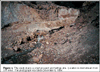
The Patagonia Mountains are the most highly mineralized part of the
Coronado National Forest but have seen little large-scale mining
development. For this reason, the area (fig. 4)is a unique laboratory
in which to study the natural effects of mineralizing processes on rocks,
water, and vegetation in arid environments. USGS scientists are beginning
studies to measure naturally occurring levels of metals in rocks, stream
sediments, water, and vegetation and to determine their mobility,
bioavailability, and leachability in this arid environment. Samples of
surficial materials are analyzed and compared with drill core data from
the Red Mountain porphyry copper deposit, which is in the Patagonia
Mountains. |
(Click on image for a larger version, 50K JPEG)
|
|
Figure 4. The creek drains a small prospect and tailings
pile. Location is downstream from 3-R mine. The photograph was taken
December 6, 1994 | |
|
The results of this work provide the data on which to base remediation
expectations and standards as new mining operations are undertaken.
Appropriate and effective remediation standards will ensure the
availability of materials, such as copper, that are critical to the
Nation's industrialized economy and, at the same time, ensure the
continued safety of drinking water and water-based recreational sites that
surround the mountain range.
|
|
|
|
Arizona is one of four States involved in U.S./Mexico border mapping
activities. The USGS is working with Federal, State, and local agencies
and other organizations in the United States and Mexico to develop
digital-map data for a 100-mile zone on each side of the border. The USGS
is obtaining color infrared aerial photography for the zone on the U.S.
side of the border. From these aerial photographs, the USGS produces
digital orthophotoquads that are used to revise maps and data bases to
support studies by scientists and government agencies that deal with the
environment and resource management.
|
|
|
|
Work is pursued in partnership with numerous State, local, and tribal
agencies, as well as Mexican agencies. A few examples not referenced
above are the Flood Control District of Maricopa County, the Pima County
Department of Transportation and Flood Control District, the city of
Tucson, the White Mountain Apache Tribe, and Consejo Recursos Minerales.
The USGS provides support to the Arizona Water Resources Research
Institute, which conducts research, education, and information and
technology transfer. |