PROVISIONAL DATA SUBJECT TO REVISION
Click to hidestation-specific text
Funding for this site is provided by:
 STATION.--01573560 SWATARA CREEK NEAR HERSHEY, PA
LOCATION.--Lat 40`17'54", long 76`40'05", Dauphin County, Hydrologic Unit 02050305, on left bank, 0.4 mi downstream from Manada Creek, 0.5 mi upstream from State Highway 39, and 1.5 mi northwest of Hershey.
DRAINAGE AREA.--483 square miles.
PERIOD OF RECORD.--October 1975 to current year.
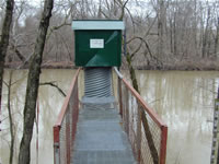
GAGE.--Water-stage recorder, crest-stage gage, and gated concrete control. Datum of gage is 325.94 ft above National Geodetic Vertical Datum of 1929. (levels by Susquehanna River Basin Commission).
COOPERATION.--Station established and maintained by the U.S. Geological Survey. Funding for the operation of this station is provided by the Pennsylvania Department of Environmental Protection and the U.S. Geological Survey.
REMARKS.--Flows are diverted by Hershey Chocolate Company.
GAGE HEIGHTS OF IMPORTANCE.-
Supplied by USGS: Maximum recordable gage height and data transmitter operational limit - 27.6 ft;
Supplied by NWS: Action stage-6 ft; Flood stage-7 ft, the right, or north, bank begins to overflow; several roadways upstream of gage are affected by high water; Moderate flood stage-10 ft, a few homes adjacent to the creek upstream of the Rte 39 bridge flood; Major flood stage-14 ft, numerous homes adjacent to the creek are affected by high water.
Summary of all available data for this site
Instantaneous-data availability statement

