Global Navigation Satellite System

|
Real-Time Network (RTN) SurveyingRTN surveying is similar in concept to Real-Time Kinematic (RTK) surveying in that corrections sent from a base station improve rover positional accuracy in real time. The primary difference is that unlike RTK surveying, where the reference station is physically located at a permanent or semi-permanent location, RTN surveying uses a computed or "virtual" reference station. General Concept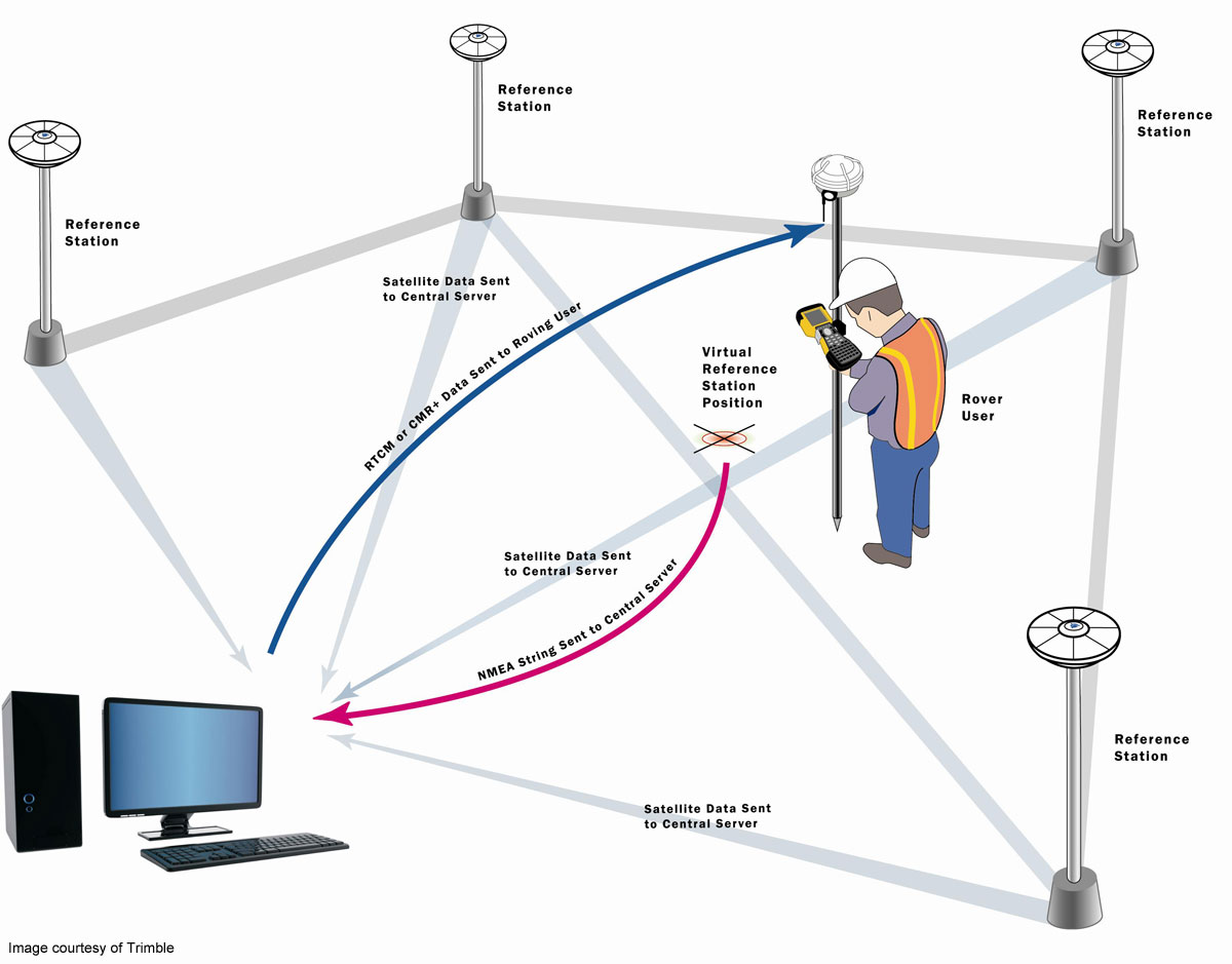
With RTN surveying, a permanent network of reference stations is required. Spacing of the reference stations can be 10-50 miles and can cover a local, regional, or statewide area. The reference station network continuously streams data (using LAN, Internet, or radio links) to a central location (server). The server then performs several functions including storage of RINEX data, performance of quality assurance checks on the raw data, network modeling and estimation of systematic errors, calculation of and conversion of correction data to a user format (RTCM format or CMR+), and communication of the data to the users. The user then receives the corrections (using LAN, Internet, radio links, or a cellular modem) in real time. The basic scenario for RTN surveying is a follows:
After initialization, the survey proceeds in exactly the same manner as an RTK survey. As always, standard survey practices should be followed: stay within the RTN, check accuracy of field-survey results against control points (benchmarks) that surround the work area(s), perform in-field calibration of survey job if necessary, and take redundant, independent readings of a selected number of survey points. Whenever the user moves a set distance (3 to 5 miles) within a set of reference stations or moves into a new area surrounded by a different set of reference stations, a new virtual reference station and corrections are computed. This ensures that small baseline distances are maintained. As with any style of surveying, the accuracy of RTN surveying depends on many factors including the reference station distances, equipment and its settings, survey procedures, and the survey environment. Accuracy typically is in the range of, and in some cases can exceed, that of traditional RTK surveying. Benefits and Limitations of RTN surveyingBenefits of RTN surveying over traditional RTK surveying include:
Limitations include:
Current Real-Time NetworksLinked here is a listing of some available Real-Time Networks. It is not intended to be all inclusive. The list includes public and private organizations and is for descriptive purposes only and does not imply endorsement by the U.S. Government. 
|

![]() U.S. Department of the Interior |
U.S. Geological Survey
U.S. Department of the Interior |
U.S. Geological Survey
URL: http://water.usgs.gov/osw/gps/real-time_network.html
Page Contact Information: Contact USGS
Page Last Modified: Wednesday, 10-Feb-2016 19:18:26 EST
