
USGS Flood Information Active
View current flooding conditions
Access streamflow, precipitation, rate of change, NWS weather and flood stage, and more in the new National Water Dashboard
Flood Event Viewer
Access information and data associated with short-term, storm-event-based collection efforts
Visualize flooding
Interactive data visualizations for flooding related to hurricanes and flood events, quarterly streamflow summaries, and more
The USGS collects flood data and conducts targeted flood science to help Federal, State, and local agencies, decision makers, and the public before, during, and after a flood. Our efforts provide situational awareness, drive predictive models, inform infrastructure design and operation, undergird floodplain mapping, assist flood constituent/load quantification, and facilitate flood impact assessments.
Use this website to discover real-time and historic flood data and scientific investigations, and learn how we collect data while addressing logistical and technical challenges.
USGS Flood Current Conditions and Notifications
The USGS offers multiple products that allow our stakeholders and the public to be notified of high-flow conditions and USGS flood response activities:
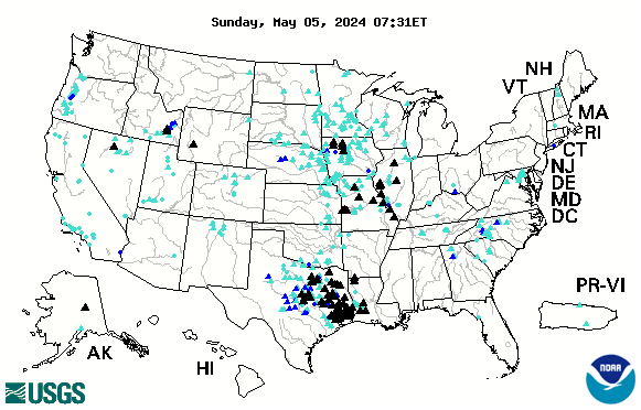
- WaterWatch: Access current flood and high-flow conditions (image below), along with other streamflow information
- Regional and Local Flood Alerts: View current and historical alerts of flooding and response activities; subscribe to RSS feeds
- WaterAlert: The WaterAlert service provides notifications to your email or phone for changes in water conditions based on thresholds you choose.

Other USGS Flood Resources
Flood Resources from our Partners

National Weather Service River Observations and Forecast
National Weather Service Riverwatch: Mississippi River Basin Forecasts
Below are other science projects associated with USGS flood information and activities.
Water Data Visualizations

Rapid Deployment Gages (RDGs)

StreamStats: Streamflow Statistics and Spatial Analysis Tools for Water-Resources Applications

Surge, Wave, and Tide Hydrodynamics (SWaTH) Network

USGS Flood Event Viewer: Providing Hurricane and Flood Response Data

Historical Flooding

Flood Inundation Mapping (FIM) Program
The USGS collects flood data and conducts targeted flood science to help Federal, State, and local agencies, decision makers, and the public before, during, and after a flood. Our efforts provide situational awareness, drive predictive models, inform infrastructure design and operation, undergird floodplain mapping, assist flood constituent/load quantification, and facilitate flood impact assessments.
Use this website to discover real-time and historic flood data and scientific investigations, and learn how we collect data while addressing logistical and technical challenges.
USGS Flood Current Conditions and Notifications
The USGS offers multiple products that allow our stakeholders and the public to be notified of high-flow conditions and USGS flood response activities:
- WaterWatch: Access current flood and high-flow conditions (image below), along with other streamflow information
- Regional and Local Flood Alerts: View current and historical alerts of flooding and response activities; subscribe to RSS feeds
- WaterAlert: The WaterAlert service provides notifications to your email or phone for changes in water conditions based on thresholds you choose.
Other USGS Flood Resources
Flood Resources from our Partners
National Weather Service River Observations and Forecast
National Weather Service Riverwatch: Mississippi River Basin Forecasts
Below are other science projects associated with USGS flood information and activities.