USGS Groundwater Information
Groundwater Resources Program
![[Photo: Groundwater flowing out of well.]](/ogw/gwrp/images/flowingwell-vsm.jpg)
New & Noteworthy
USGS Groundwater WatchUSGS maintains a network of active wells to provide basic statistics about groundwater levels. ![[Image: USGS active water level wells location map.]](http://groundwaterwatch.usgs.gov/sm_ogw.png "USGS Groundwater Watch")
Other Water TopicsUSGS in Your StateUSGS Water Science Centers are located in each state. ![[Map: There is a USGS Water Science Center office in each State.]](/ogw/images/usmapsmall.gif)
|
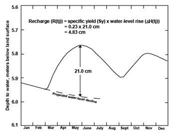
Water-Table Fluctuation (WTF) MethodGraphical Approach for Estimating Recharge Using the WTF Method
In the graphical approach to determine DH(tj) for the WTF method, the antecedent recession curves are extrapolated manually on the basis of visual inspection of the entire data set. When viewed with corresponding precipitation data, rises that are not caused by precipitation (and therefore do not indicate recharge) can be identified clearly and eliminated from the recharge calculations. Examples of rises not caused by precipitation include electrical surges, changes in barometric pressure, cessation of pumping, earth tide effects, entrapped air, temperature variations, and manual adjustment to the water-level measuring device (Freeze and Cherry, 1979). This approach involves more subjectivity than the other WTF approaches, and different users no doubt would produce slightly different recession curves. This is an especially tough problem when water levels are changing rapidly and multiple recharge events follow closely, such as in fractured rock settings. |

![]() U.S. Department of the Interior |
U.S. Geological Survey
U.S. Department of the Interior |
U.S. Geological Survey
URL: http://water.usgs.gov/ogw/gwrp/methods/wtf/estimating_graphical.html
Page Contact Information: Contact the Groundwater Resources Program
Page Last Modified: Tuesday, 03-Jan-2017 20:46:52 EST