
The formation, persistence, size, and function of wetlands are controlled by hydrologic processes. Distribution and differences in wetland type, vegetative composition, and soil type are caused primarily by geology, topography, and climate. Differences also are the product of the movement of water through or within the wetland, water quality, and the degree of natural or human-induced disturbance. In turn, the wetland soils and vegetation alter water velocities, flow paths, and chemistry. The hydrologic and water-quality functions of wetlands, that is, the roles wetlands play in changing the quantity or quality of water moving through them, are related to the wetland's physical setting.
Wetlands are distributed unevenly throughout the United States because of differences in geology, climate, and source of water (fig. 17). They occur in widely diverse settings ranging from coastal margins, where tides and river discharge are the primary sources of water, to high mountain valleys where rain and snowmelt are the primary sources of water. Marine wetlands (those beaches and rocky shores that fringe the open ocean) are found in all coastal States. Estuarine wetlands (where tidal saltwater and inland freshwater meet and mix) are most plentiful in Alaska and along the southeastern Atlantic coast and the gulf coast. Alaska has the largest acreage of estuarine wetlands in the United States, followed by Florida and Louisiana.
Inland (nontidal) wetlands are found in all States. Some States, such as West Virginia, have few large wetlands, but contain many small wetlands associated with streams. Other States, such as Nebraska, the Dakotas, and Texas, contain many small isolated wetlands--the lakes of the Nebraska Sandhills, the prairie potholes, and the playa lakes, respectively. Northern States such as Minnesota and Maine contain numerous wetlands with organic soils (peatlands), similar in origin and hydrologic and vegetative characteristics to the classic bog and fen peatlands of northern Europe. However, peatlands are by no means limited to Northern States--they occur in the Southeastern and Midwestern United States wherever the hydrology and chemical environment are conducive to the accumulation of organic material.
 (Click on image for a larger version, 50K) |
|
Figure 17. Major wetland areas in the United States and location of sites mentioned in the text. (Source: Data from T.E. Dahl, U.S. Fish and Wildlife Service, unpub. data, 1991.) |
Wetlands occur on flood plains--for example, the broad bottom-land hardwood forests and river swamps (forested wetlands) of southern rivers and many of the narrow riparian zones along streams in the Western United States. Wetlands are commonly associated with lakes or can occur as isolated features of the landscape. They can form large complexes of open water and vegetation such as The Everglades of Florida, the Okefenokee Swamp of Georgia and Florida, the Copper River Delta of Alaska, and the Glacial Lake Agassiz peatland of Minnesota.
|
Sorry, this photo is not yet available |
| Typical prairie pothole wetland in North Dakota. (Photograph by Virginia Carter, U.S. Geological Survey.) |
|
Sorry, this photo is not yet available |
| Glacial Lake Agassiz peatland, Minnesota. (Photograph by Virginia Carter, U.S. Geological Survey.) |
HYDROLOGIC PROCESSES IN WETLANDS
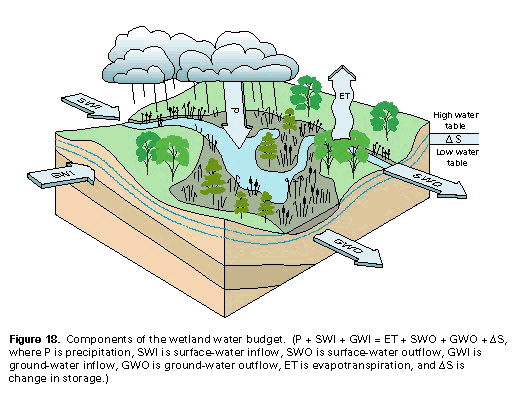
The wetland water budget is the total of inflows and outflows of water from a wetland. The components of a budget are shown in the equation in figures 18 and 19. The relative importance of each component in maintaining wetlands varies both spatially andtemporally, but all these components interact to create the hydrology of an individual wetland.
 (Click on image for a larger version, 66K) |
| Figure 18. Components of the wetland water budget. (P + SWI + GWI = ET + SWO + GWO + �S, where P is precipitation, SWI is surface-water inflow, SWO is surface-water outflow, GWI is ground-water inflow, GWO is ground-water outflow, ET is evapotranspiration, and �S is change in storage.) |
Determining water budgets for wetlands is imprecise because as the climate varies from year to year so does the water balance. The accuracy of individual components depends on how well they can be measured and the magnitude of the associated errors (Winter, 1981; Carter, 1986). However, water budgets, in conjunction with information on the local geology, provide a basis for understanding the hydrologic processes and water chemistry of a wetland, understanding its functions, and predicting the effects of natural or human-induced hydrologic alterations. Each of the components is discussed below.
Water budgets provide a basis for understanding hydrologic processes of a wetland.
|
Sorry, this photo is not yet available |
| Figure 19. Water budgets for selected wetlands in the United States and Canada. (P + SWI + GWI = ET + SWO + GWO + �S, where P is precipitation, SWI is surface-water inflow, SWO is surface-water outflow, GWI is ground-water inflow, GWO is ground-water outflow, ET is evapotranspiration, and �S is change in storage. Components are expressed in percentages. Abbreviations used: < = less than; > = greater than.) (Sources from left to right and top to bottom: Novitzki, 1978; Roulet and Woo, 1986; Rykiel, 1984; Rykiel, 1984; Mitsch and Gosselink, 1993; and Gehrels and Mulamoottil, 1990.) |
Precipitation
Evapotranspiration
 (Click on image for a larger version, 50K) |
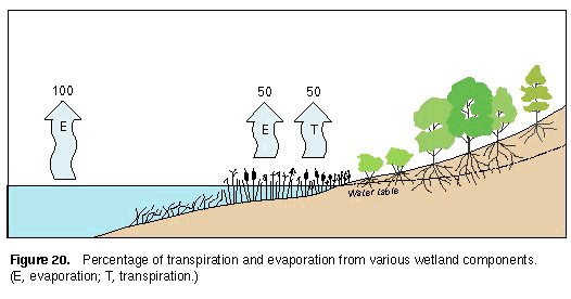
| Figure 20. Percentage of transpiration and evaporation from various wetland components. (E, evaporation; T, transpiration.) |
Surface Water
Streamflow from wetlands that have a large component of ground-water discharge tends to be more evenly distributed throughout the year than streamflow from wetlands fed primarily by precipitation (fig. 21). This is because ground-water discharge tends to be relatively constant in quantity compared with precipitation and snowmelt.
 (Click on image for a larger version, 50K) |
| Figure 21. Monthly streamflow from two wetlands in northern Minnesota; A, a perched bog whose inflow component is primarily precipitation, and B, a fen whose inflow component is primarily ground water. (Source: Modified from Boelter and Verry, 1977.) |
Ground Water
Wetlands most commonly are ground-water discharge areas; however, ground-water recharge also occurs. Ground-water recharge or discharge in wetlands is affected by topographic position, hydrogeology, sediment and soil characteristics, season, ET, and climate and might not occur uniformly throughout a wetland. Recharge rates in wetlands can be much slower than those in adjacent uplands if the upland soils are more permeable than the slightly permeable clays or peat that usually underlie wetlands.
Coastal wetlands and shallow embayments represent the lowest point in regional and local ground- water flow systems; ground water discharges into these areas, sometimes in quantities large enough to affect the chemistry of estuaries (Valiela and Costa, 1988; Valiela and others, 1990). The quantity of ground water discharged varies throughout the tidal cycle, affecting the water chemistry of the wetland soils (Harvey and Odum, 1990; Valiela and others, 1990).
The hydrology of a wetland is largely responsible for the vegetation of the wetland.
 (Click on image for a larger version, 50K) |
| Figure 22. Ground-water flow systems. Local ground-water flow systems are recharged at topographic highs and discharged at immediately adjacent lows. Regional ground-water flow systems are recharged at the major regional topographic highs and discharged at the major regional topographic lows. Intermediate flow systems lie between the other two systems. (Source: Modified from Winter, 1976.) |
Storage
 (Click on image for a larger version, 66K) |
|
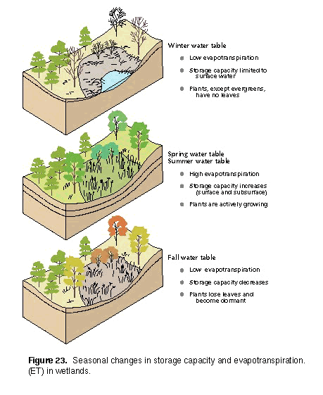
Figure 23. Seasonal changes in storage capacity and evapotranspiration (ET) in wetlands. |
SOME EFFECTS OF HYDROLOGY ON WETLAND VEGETATION
The vegetation affects the value of the wetland to animals and people.
HYDROGEOLOGIC SETTINGS
 (Click on image for a larger version, K) |
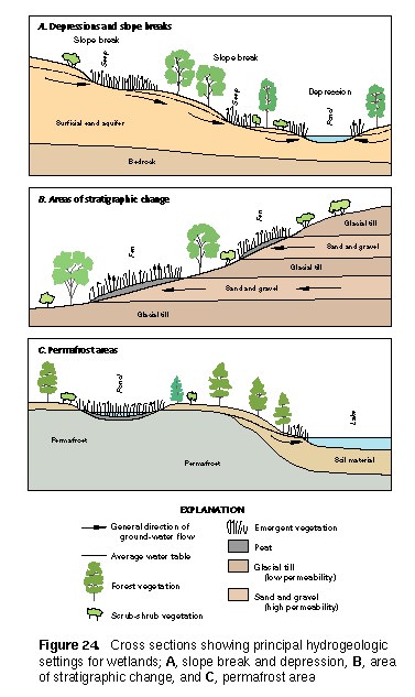
| Figure 24. Cross sections showing principal hydrogeologic settings for wetlands; A, slope break and depression, B, area of stratigraphic change, and C, permafrost area. |
Topographic Depressions
Glacial movement.--Glaciers shaped the landscape of many of the Northern States and caused wetlands to form in mountainous areas such as the Rocky Mountains and the northern Appalachians. As the glaciers advanced over the Northern United States they gouged and scoured the land surface, making numerous depressions, depositing unsorted glacial materials, and burying large ice masses. As the climate warmed, the glaciers retreated, leaving behind the depressions and the large masses of buried ice. As the temperatures continued to warm, the ice masses melted to form kettle holes. In many cases, water filled the depressions and kettle holes, forming lakes. As the lakes filled with sediments, they were replaced by wetlands.
Water movement.--Wetlands also are formed by the movement of water as it flows from upland areas toward the coast. The flow characteristics of water are partly determined by the slope of the streambed. On steeply sloping land, water generally flows rapidly through relatively deep, well-defined channels. As the slope decreases, the water spreads out over a wider area and channels usually become shallower and less defined. Shallow channels tend to meander or move back and forth across the flood plain. The changes in flow path sometimes result in oxbow lakes and flood-plain wetlands. When the river floods, the isolated oxbow lakes begin to fill with sediment, providing an excellent place for more wetlands to form. Obstruction to the normal flow of water also can cause the water to change course and leave gouges in front of or channels around the obstruction, or can cause water to be impounded behind the obstruction. Many lakes and wetlands are formed behind dams made by humans or beavers.
Tectonic activities.--Tectonic activity is responsible for depression wetlands such as Reelfoot Lake on the Mississippi River flood plain in Tennessee caused by the 1812 New Madrid earthquake. Earthquakes result when two parts of the Earth's crust move relative to each other, causing displacement of land. When this occurs, depressions may result along the lines of displacement or the flow paths of rivers may be changed, leaving isolated bodies of water. When a source of water coincides with these depressions, wetlands can form.
Subsidence and collapse features.--Land subsidence and collapse also can form depressions in which wetlands and lakes occur. In some areas, especially in the Southwest, pumping of ground water has caused the land above an aquifer to sink, forming depressions where water collects and wetlands develop. In karst topography (landscapes resulting from the solution of carbonate rocks such as limestone), such as is found in Florida, wetlands form in sinkholes. Collapse of volcanic craters produces calderas that fill with water and sediment and contain lakes or wetlands.
|
Sorry, this photo is not yet available |
| Infrared color photograph of oxbow lakes in the drainage area of Hoholitna River near Sleetmute, Alaska. (Photograph courtesy of National Aeronautics and Space Administration.) |
|
Sorry, this photo is not yet available |
| Lotus in Reelfoot Lake, Tennessee. (Photograph by Virginia Carter, U.S. Geological Survey.) |
|
Sorry, this photo is not yet available |
| Coastal marsh along San Francisco Bay, California. (Photograph by Virginia Carter, U.S. Geological Survey.) |
|
Sorry, this photo is not yet available |
| This recently collapsed sinkhole, in central Florida, provides an ideal spot for a wetland to form. (Photograph by Terry H. Thompson, U.S. Geological Survey.) |
Slope Breaks
The water table sometimes intersects the land surface in areas where the land is sloping. Where there is an upward break or change in slope, ground water moves toward the water table in the flatter landscape (fig. 24A) (Roulet, 1990; Winter and Woo, 1990). Where ground water discharges to the land surface, wetlands form on the lower parts of the slope. Constant ground-water seepage maintains soil saturation and wetland plant communities. The Great Dismal Swamp of Virginia and North Carolina is maintained by seepage of ground water at the slope break at the bottom of an ancient beach ridge that runs along the western edge (Carter and others, 1994).Areas of Stratigraphic Change
Where stratigraphic changes occur near land surface, the layering of permeable and less-permeable rocks or soils affects the movement of ground water. When water flowing through the more permeable rock encounters the less permeable rock, it is diverted along the surface of the less permeable rock to the land surface. The continual seepage that occurs at the surface provides the necessary moisture for a wetland (fig. 24B). Fens in Iowa form on valley-wall slopes where a thin permeable horizontal layer of rock is sandwiched between two less permeable layers and continual seepage from the permeable layer causes the formation of peat (Thompson and others, 1992).Permafrost Areas
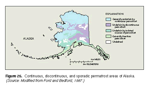 (Click on image for a larger version, K) |
| Figure 25. Continuous, discontinuous, and sporadic permafrost areas of Alaska. (Source: Modified from Ford and Bedford, 1987.) |
WATER QUALITY IN WETLANDS
HYDROLOGIC AND WATER-QUALITY FUNCTIONS OF WETLANDS
The hydrologic and water-quality functions of wetlands are controlled by the following:
- Landscape position (elevation in the drainage basin relative to other
wetlands, lakes, and streams)
- Topographic location (depressions, flood plains, slopes)
- Presence or absence of vegetation
- Type of vegetation
- Type of soil
- The relative amounts of water flowing in and water flowing out of the wetland
- Local climate
- The hydrogeologic framework
- The geochemistry of surface and ground water
Natural functions of wetlands can be altered or impaired by human activity. Although slow incremental changes in the natural landscape can lead to small changes in wetlands, the accumulation of these small changes can permanently alter the wetland function (Brinson, 1988). Some of the major hydrologic and water-quality functions of wetlands--(1) flood storage and stormflow modification, (2) ground-water recharge and discharge, (3) alterations of precipitation and evaporation, (4) maintenance of water quality, (5) maintenance of estuarine water balance, and (6) erosion reduction--are discussed below.
The effectiveness and magnitude of a function varies from wetland to wetland.
Flood Storage and Stormflow Modification
A strong correlation exists between the size of flood peaks and basin storage (percentage of basin area occupied by lakes and wetlands) in many drainage basins throughout the United States (Tice, 1968; Hains, 1973; Novitzki, 1979, 1989; Leibowitz and others, 1992). Novitzki (1979, 1989) found that basins with 30 percent or more areal coverage by lakes and wetlands have flood peaks that are 60 to 80 percent lower than the peaks in basins with no lake or wetland area. Wetlands can provide cost-effective flood control, and in some instances their protection has been recognized as less costly than flood-control measures such as reservoirs or dikes (Carter and others, 1979). Loss of wetlands can result in severe and costly flood damage in low-lying areas of a basin.
Wetlands can influence weather and climate.
Ground-Water Recharge and Discharge
Recharge to aquifers can be especially important in areas where ground water is withdrawn for agricultural, industrial, and municipal purposes. Wetlands can provide either substantial or limited recharge to aquifers. Much of the recharge to the Ogallala aquifer in West Texas and New Mexico is from the 20,000 to 30,000 playa lakes rather than from areas between lakes, ephemeral streams, and areas of sand dunes (Wood and Osterkamp, 1984; Wood and Sanford, 1994). Recharge takes place through the bottoms of some streams, especially in karst topography and in the arid West. Some recharge also takes place when floodwater moves across the flood plain and seeps down into the water-table aquifer. Cypress domes in Florida and prairie potholes in the Dakotas also are thought to contribute to ground-water recharge (Carter and others, 1979). Ground-water recharge from a wetland can be induced when aquifer water levels have been drawn down by nearby pumping.
Alterations of Precipitation and Evaporation
Maintenance of Water Quality
Water-quality modification can affect an entire drainage basin or it may affect only an individual wetland. Water chemistry in basins that contain a large proportion of wetlands is usually different from that in basins with fewer wetlands. Basins with more wetlands tend to have water with lower specific conductance and lower concentrations of chloride, lead, inorganic nitrogen, suspended solids, and total and dissolved phosphorus than basins with fewer wetlands. Generally, wetlands are more effective at removing suspended solids, total phosphorus, and ammonia during high-flow periods and more effective at removing nitrates at low-flow periods (Johnston and others, 1990). Novitzki (1979) reported that streams in a Wisconsin basin, which contained 40 percent wetland and lake area, had sediment loads that were 90 percent lower than in a comparable basin with no wetlands. Wetlands may change water chemistry sequentially; that is, upstream wetlands may serve as the source of materials that are transformed in downstream wetlands. Estuaries and tidal rivers depend on the flow of freshwater, sediments, nutrients, and other constituents from upstream.
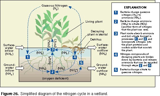
Organic carbon in the form of plant tissues and peat accumulates in wetlands creating a source of water-borne dissolved and particulate organic materials. Some materials, for example nutrients, are changed from one form to another as they pass through the wetland (fig. 26). Most stored materials in wetlands are immobilized as a result of prevailing water chemistry and hydrology, but any disturbance can result in release of those materials.
The water purification functions of wetlands are dependent upon four principal components of the wetland--substrate, water, vegetation, and microbial populations (Hammer, 1992; Hemond and others, 1987).
 (Click on image for a larger version, K) |
| Figure 26. Simplified diagram of the nitrogen cycle in a wetland. |
Water.--Ground and surface waters transport solid materials and gases to the microbial and plant communities, remove the by-products of chemical and biological reactions from the wetlands, and maintain the environment in which the essential biochemical processes of wetlands occur. Flooding or soil saturation causes oxygen-deficient conditions that markedly influence many biological transformations.
Vegetation.--Wetland vegetation reduces the flow and decreases velocities of water, causing the deposition of mineral and organic particles and constituents attached to them, such as phosphorus or trace metals. Plants introduce oxygen to the generally oxygen-deficient soil environment through their roots, creating an oxidized root zone where bacterial transformations of nitrogenous and other compounds can occur (Good and Patrick, 1987). Plants also provide a surface for microbial colonization. Wetland plants remove small quantities of nutrients, trace metals, and other compounds from the soil water and incorporate them into plant tissue, which may later be recycled in the wetland through decomposition, stored as peat, or transported from the wetland as particulate matter (Boyt and others, 1977; Tilton and Kadlec, 1979; Hammer, 1992).
Wetlands serve as short-term or long-term sediment sinks. Floodwater spreading out across a wetland decreases in velocity, and sediments settle out and are trapped within the wetland. Some of this sediment may be transported out of the wetland during future flooding. Sediment deposition in estuarine wetlands provides a constant input that is of special importance for maintenance of wetlands acreage during periods of sea-level rise (Bricker-Urso and others, 1989).
The ability of wetlands to filter and transform nutrients and other constituents has resulted in the construction and use of artificial wetlands in the United States and other countries to treat wastewater and acid mine drainage (Hammer, 1989, 1992; Wieder, 1989). However, individual wetlands have a limited capacity to absorb nutrients and differ in their ability to do so (Tiner, 1985). A wetland's effectiveness in improving water quality depends on hydrologic patterns, amount and type of vegetation, time of year, and the constituent of concern (Zedler and others, 1985).
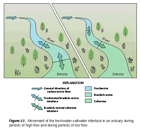
Estuarine Water Balance
 (Click on image for a larger version, K) |
| Figure 27. Movement of the freshwater-saltwater interface in an estuary during periods of high flow and during periods of low flow. |
Wetlands reduce the erosive forces of wind and waves.