![]()
|
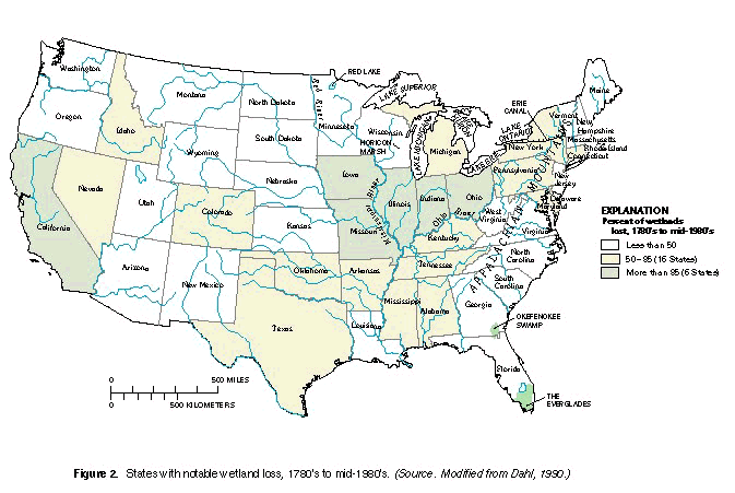
At the time of European settlement in the early 1600's, the area that was
to become the conterminous United States had approximately 221 million
acres of wetlands. About 103 million acres remained as of the mid-1980's
(Dahl and Johnson, 1991). Six States lost 85 percent or more of their
original wetland acreage--twenty-two lost 50 percent or more (Dahl, 1990)
(fig. 2). Even today, all of the effects of
these losses might not be fully realized.
|
Historical events, technological innovations, and values of society sometimes had destructive effects on wetlands. By examining the historical backdrop of why things happened, when they happened, and the consequences of what happened, society can better appreciate the importance of wetlands in water-resource issues. Society's views about wetlands have changed considerably--especially in the last half century. Interest in the preservation of wetlands has increased as the value of wetlands to society has become more fully understood. From a cultural standpoint, it is interesting to understand how changes in opinions and values came about, and what effects these changes had on wetland resources. From an ecological perspective, it is important to understand how the loss of wetlands affects fish, wildlife, and the environment as a whole. |
|
Early 1600's to 1800--Colonial Settlement | ||||
|
Wetland drainage began with permanent settlement of Colonial America.
Throughout the 1600's and 1700's, colonization was encouraged by European
monarchs to establish footholds in North America. The effects of this
colonization on the landscape became obvious in the early to mid-1700's. Much of our knowledge of early wetlands comes from maps and other documents that survived over time. The origins of settlers influenced both where people settled and how they mapped and used natural resources. Few records exist because the original English, French, and Spanish settlements were established before the land was surveyed. Settlements in the North tended to be clustered, whereas communities in the South were more widely scattered because of the predominance of agriculture. Many different land surveying systems resulted in an incomplete patchwork of ownership that ultimately caused many legal problems due to boundary errors and overlapping claims (Garrett, 1988). It was not until 1785 that the Land Ordinance Act established the United States Public Land Survey, which required surveying and partitioning of land prior to settlement. Although not established to provide information on natural resources, surveys do provide some information about the distribution and location of wetlands. |
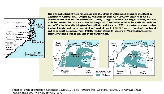
During the 1700's, wetlands were regarded as swampy lands that bred diseases, restricted overland travel, impeded the production of food and fiber, and generally were not useful for frontier survival. Settlers, commercial interests, and governments agreed that wetlands presented obstacles to development, and that wetlands should be eliminated and the land reclaimed for other purposes. Most pioneers viewed natural resources from wetlands as things to be used without limit (Tebeau, 1980). The most productive tracts of land in fertile river valleys in parts of Virginia had been claimed and occupied before 1700. The resulting shortage of choice land stimulated colonists to move south to the rich bottom lands along the Chowan River and Albemarle Sound of North Carolina on the flat Atlantic coastal plain. Initially, settlements consisted primarily of shelters and subsistence farms on small tracts of land. To extend the productive value of available land, wetlands on these small tracts were drained by small hand-dug ditches. During the mid- to late 1700's, as the population grew, land clearing and farming for profit began to affect larger tracts of land; many coastal plain wetlands were converted to farmland (fig. 3). Once drained, these areas provided productive agricultural lands for growing cash crops. |
Interest in the preservation of wetlands has increased as the value of wetland has become more fully undertood.
Technical advances facilitated wetland conversion.
|
||
| ||||
|
| ||||
|
Widespread wetland drainage was most prevalent in the southern colonies.
In 1754, South Carolina authorized the drainage of Cacaw Swamp for
agricultural use (Beauchamp, 1987). Similarly, areas of the Great Dismal
Swamp in Virginia and North Carolina were surveyed in 1763 so that land
could be reclaimed for water transportation routes. Farming on large
plantations was common practice in the South and necessitated some drainage
or manipulation of wetlands.
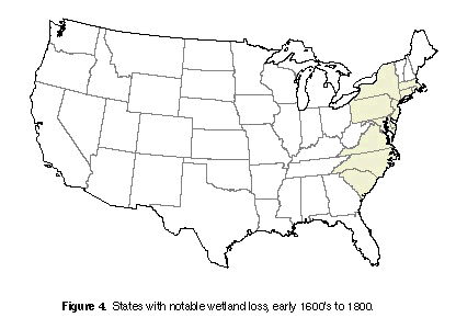
| By the 1780's, immigrants had settled along the fertile river valleys of the Northeast and as far south as present-day Georgia. Wetlands in these river valleys suffered losses with this settlement (fig. 4). Small towns and farms were established in the valleys along the rivers of Massachusetts, Connecticut, New York, and Pennsylvania. Settlement extended to the valleys beyond the Appalachian Mountains in Virginia and followed the major rivers inland through the Carolinas by 1800. |
| ||
| ||||
1800 to 1860--Westward Expansion | ||||||
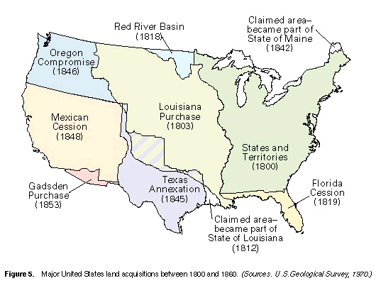
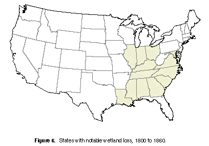
| The period between 1800 and 1860 was a time of growth in the United States. During these decades, numerous land acquisitions--the Louisiana Purchase (1803); Florida and eastern Louisiana ceded by Spain (1819); annexation of Texas (1845); the Oregon Compromise (1846); and lands ceded from Mexico (1848)--greatly expanded the land area of the United States (Garrett, 1988) (fig. 5). With this land expansion, the population grew from 7.2 million in 1810 to 12.8 million in 1830 (U.S. Bureau of the Census, 1832). Land speculation increased with this rapid growth and marked a period when land and resources seemed to be available for the taking. It was a time of rapid inland movement of settlers westward into the wetland-rich areas of the Ohio and Mississippi River Valleys (fig. 2). Large-scale conversion of wetlands to farmlands started to have a real effect on the distribution and abundance of wetlands in the United States. Areas where notable wetland loss occurred between 1800 and 1860 are shown in figure 6. |
|
|||||
|
Technical advances throughout the 1800's greatly facilitated wetland
conversions. The opening of the Erie Canal in 1825 provided settlers with
an alternative mode and route of travel from New York to the Great Lakes
States, increasing migration of farmers to the Midwest. The canal also
provided low-cost transportation of timber and agricultural products from
the Nation's interior to eastern markets and seaports (McNall, 1952).
Another innovation, the steam-powered dredge, allowed the channelizing or
clearing of small waterways at the expense of adjacent wetlands. Between
1810 and 1840, new agricultural implements--plows, rakes, and
cultivators--enabled settlers to break ground previously not considered for
farming (McManis, 1964). Mechanical reapers introduced in the 1830's
stimulated competition in, and furthered refinements of, farm equipment
marketed in the Midwest (Ross, 1956). These innovations ultimately took a
toll on wetlands as more land was drained, cleared, and plowed for farming. Wetland drainage continued. In the Midwest, the drainage of the Lake Erie marshes of Michigan and Ohio probably started about 1836. Cotton and tobacco farming continued to flourish in the Southern States and precipitated the additional drainage of thousands of acres of wetlands for conversion to cropland. |
Wetlands also were being modified in other ways. The Horicon Marsh in
Wisconsin was dammed and flooded in 1846 for a transportation route and to
provide commercial fishing. Toward the middle of the century, lumbering
was an important industry in the Midwest, supplying wood for construction
and fuel for stoves and fireplaces. Much of the Nation's timber came from
the swamp forests of Ohio, Indiana, and Illinois, which typically contained
a mix of birch, ash, elm, oak, cottonwood, poplar, maple, basswood, and
hickory. In 1849, Congress passed the first of the Swamp Land Acts, which granted all swamp and overflow lands in Louisiana to the State for reclamation. In 1850, the Act was made applicable to 12 other States, and in 1860, it was extended to include lands in two additional States (Shaw and Fredine, 1956) (table 1). Although most States did not begin immediate large-scale reclamation projects, this legislation clearly set the tone that the Federal Government promoted wetland drainage and reclamation for settlement and development. This tone pervaded policy and land-use trends for the next century. |
Table 1. Acreage granted to the States under the
authority of the Swamp Land Acts of 1849, 1850, and 1860
|
1860 to 1900--Agriculture Moves West | ||||||
|
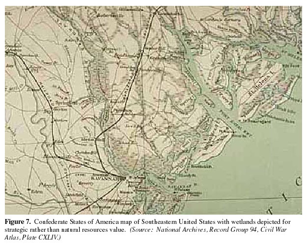
The American Civil War (1861-65) affected wetlands because traversing
swamps and marshes with heavy equipment presented major logistical
problems for both armies. The design, engineering, and construction
of transportation and communication networks were stimulated.
Attention became focused on the development of routes around, through,
or over water bodies and wetlands, and on production of accurate maps
(fig. 7). These maps provided an
early glimpse of some of the Nation's wetlands.
|
After the war, the Nation's attention focused on westward expansion and
settlement. Railroads were important in the initial development of
transportation routes. The railroads not only opened new lands, including
wetlands, to development, but the railroad industry also was a direct
consumer of wetland forest products. In the 1860's, more than 30,000 miles
of railroad track existed in the United States (Stover, 1961). The
railroads of Ohio consumed 1 million cords of wood annually just for fuel
(Gordon, 1969). The additional quantity of wood used for ties is not
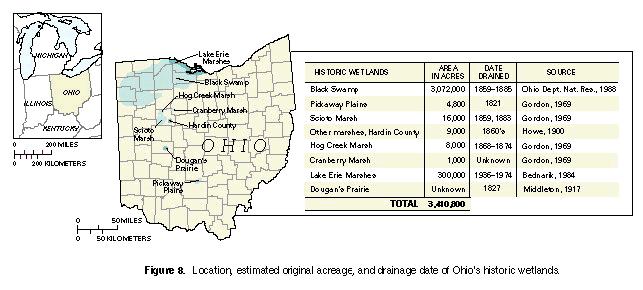
known. From 1859 to 1885, intense timber cutting and land clearing
eliminated many of Ohio's wetlands, including the Black Swamp (fig. 8).
|
| ||||
|
The Black Swamp was in the northwestern corner of Ohio and was a barrier to
travel and settlement. This forested wetland was estimated to have been
120 miles long and 40 miles wide, covering an area nearly equal in size to
Connecticut (Gordon, 1969; Ohio Department of Natural Resources, 1988).
The swamp, which was an elm-ash forested wetland typical of the region,
contained a variety of commercially valuable trees (Eyre, 1980). Nothing
was left of the Black Swamp by the end of the nineteenth century. During the mid- to late 1880's, agriculture expanded rapidly westward along the major river systems. Several regions of abundant wetlands lay directly in the path of this expansion (Wooten and Jones, 1955), including:
|
As new kinds of machinery increased the ability to till more land, the
conversion of wetlands to farmlands increased rapidly. Huge wheat farms,
or "Bonanza Farms," were operating in the Dakota Territory (present-day
North and South Dakota) by 1875. New mechanical seeders, harrowers,
binders, and threshers, designed specifically for wheat production, were
used to cultivate large tracts of land for these farms (Knue, 1988). Many
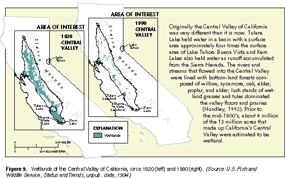
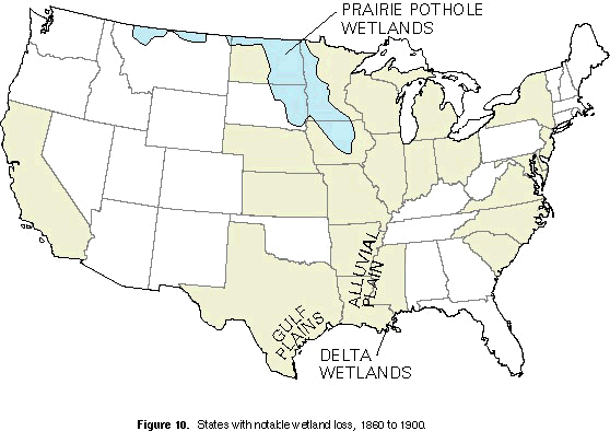
wetlands were lost as a result of these operations. Improvements in drainage technology greatly affected wetland losses in the East and the Midwest. As the use of steam power expanded, replacing hand labor for digging ditches and manufacturing drainage tiles, the production and installation of drainage tiles increased rapidly. By 1880, 1,140 factories located mainly in Illinois, Indiana, and Ohio manufactured drainage tiles that were used to drain wetlands for farming (Pavelis, 1987). By 1882, more than 30,000 miles of tile drains were operating in Indiana alone. By 1884, Ohio had 20,000 miles of public ditches designed to drain 11 million acres of land (Wooten and Jones, 1955). Wetland conversion in the Central Valley of California began in the mid-1800's, when farmers began diking and draining the flood-plain areas of the valley for cultivation (fig. 9). Other States had notable losses of wetlands between 1860 and 1900 (fig. 10). |
| ||
| ||||
| ||||
1900 to 1950--Changing Technology | ||||||
|
The first half of the twentieth century was a time of ambitious engineering
and drainage operations. Two World Wars, a rapidly growing population, and
industrial growth fueled the demand for land as industry and agriculture
propelled the United States to the status of a world leader. Technology
was increasingly important in manipulation of the Nation's water resources.
Two of the most notable projects that affected wetlands were California's
Central Valley Project and the lock and dam system on the Mississippi
River. Although draining had begun one-half century earlier, wetland modification in the Central Valley accelerated early in the 20th century. By the 1920's, about 70 percent of the original wetland acreage had been modified by levees, drainage, and water-diversion projects (Frayer and others, 1989). In the 1930's, large-scale flood-control projects, diversion dams, and water-control structures were being built on the tributary rivers entering the valley.
| Wetland modification also continued farther east. Before the installation of the lock and dam system in 1924, the bottom lands of the Mississippi River corridor were primarily wooded islands separated by deep sloughs (Green, 1984). Hundreds of small lakes and ponds were scattered throughout extensive wooded areas. The river channel was subject to shifting sands and shallows, and changed constantly. Lake and dam structures were built to create a permanent navigable waterway. The water depth increased behind each dam to create a pool that extended upstream to the next dam. The first pool was filled in 1935 and the system was completed when the last pool was filled in 1959. The resulting changes to the river system eliminated large water-level fluctuations and helped stabilize water depth and flooding. Bottom lands no longer dried out in summer, and former hay meadows and wooded areas were converted to marshlands surrounding the pools. One type of wetland was exchanged for another. Although some pools of the Upper Mississippi River have problems with silt deposition and restricted water circulation, these "created"wetland areas provide habitat for fur-bearing animals, waterfowl, and fish. | |||||
|
| ||||||
|
In other parts of the country, this era was marked by urban and
agricultural expansion projects that drained both large and small wetlands.
Some of the most ambitious projects were attempts to drain and cultivate
Horicon Marsh in Wisconsin in 1904; commercial timber harvesting in
southern Georgia, which began in 1908 as a precursor to attempts to drain
the Okefenokee Swamp (Trowell, 1988); and in 1914, the draining of North
Carolina's largest natural lake, Lake Mattamuskeet, to create farmland
(U.S. Fish and Wildlife Service, undated). Early in the century, land
developers dug drainage ditches in an attempt to drain a huge area for
development in the vast peatlands north of Red Lake, Minn. (Glaser, 1987).
On July 29, 1917, the Minneapolis Sunday Tribune ran a full page
advertisement to attract homesteaders to the Red Lake area--"perhaps the
last of the unsettled, uncut timberland in the middle of the country"
(Wright, 1984). By 1930, nearly all of the prairie wetlands in Iowa, the
southern counties of Minnesota, and the Red River Valley in North Dakota
and Minnesota were drained (Schrader, 1955). Attempts were underway to drain and farm large parts of The Everglades (a huge expanse of wetlands in southern Florida). By the 1930's, more than 400 miles of drainage canals were already in place (Lord, 1993). (See article "Wetland Resources of Florida"in the State Summaries section of this volume.) With the passage of the Sugar Act of 1934, additional wetlands in southern Florida were drained and put into sugarcane production. Sugarcane yields more than doubled from 410,000 to 873,000 tons between 1931 and 1941 (Clarke, 1977), largely at the expense of wetland acreage. Severe flooding in southern Florida in the 1920's and again in the 1940's prompted the U.S. Army Corps of Engineers to build the Central and Southern Florida Project for flood control. This massive undertaking, which required levees, water-storage areas, channel improvements, and large pumps, caused additional large modification to The Everglades' environment (Light and Dineen, 1994). |
Mechanized farm tractors had replaced horses and mules for farm labor
during this half century. The tractors could be used more effectively than
animals for drainage operations, and the old pasture land then became
available for improvement and production of additional crops. In the
Midwest and the North-central States, the use of tractors probably
contributed to the loss of millions of acres of small wetlands and prairie
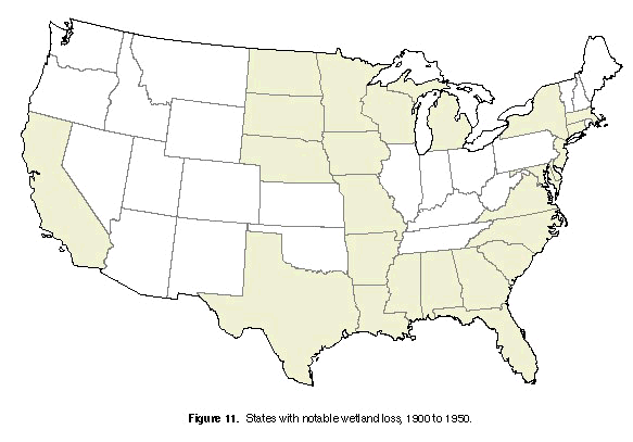
potholes. In the 1930's, the U.S. Government, in essence, provided free engineering services to farmers to drain wetlands; and by the 1940's, the Government shared the cost of drainage projects (Burwell and Sugden, 1964). Organized drainage districts throughout the country coordinated efforts to remove surface water from wetlands (Wooten and Jones, 1955). Figure 11 shows areas of notable wetland losses between 1900 and 1950.
In 1934, in stark contrast to these drainage activities, Congress passed the Migratory Bird Hunting Stamp Act. This Act was one of the first pieces of legislation to initiate the process of acquiring and restoring America's wetlands. |
The Migratory Bird Hunting Stamp Act was one of the first pieces of legislation to initiate the process of acquiring and restoring America's wetlands.
| ||||
1950 to Present--Changing Priorities and Values | ||||
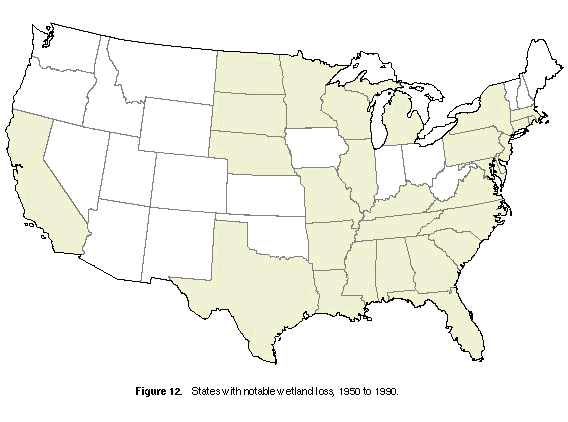
| By the 1960's, most political, financial, and institutional incentives to drain or destroy wetlands were in place. The Federal Government encouraged land drainage and wetland destruction through a variety of legislative and policy instruments. For example, the Watershed Protection and Flood Prevention Act (1954) directly and indirectly increased the drainage of wetlands near flood-control projects (Erickson and others, 1979). The Federal Government directly subsidized or facilitated wetland losses through its many public-works projects, technical practices, and cost-shared drainage programs administered by the U.S. Department of Agriculture (Erickson, 1979). Tile and open-ditch drainage were considered conservation practices under the Agriculture Conservation Program--whose policies caused wetland losses averaging 550,000 acres each year from the mid-1950's to the mid-1970's (Office of Technology Assessment, 1984). Agriculture was responsible for more than 80 percent of these losses (Frayer and others, 1983). Figure 12 shows States with notable wetland losses between 1950 and 1990. | Since the 1970's, there has been increasing awareness that wetlands are valuable areas that provide important environmental functions. Public awareness of, and education about, wetlands has increased dramatically since the early 1950's. Federal policies, such as the "Swampbuster,"have eliminated incentives and other mechanisms that have made the destruction of wetlands technically and economically feasible. New laws, such as the Emergency Wetland Resources Act of 1986, also curtail wetland losses. (See article "Wetland Protection Legislation"in this volume for information on legislation affecting wetlands.) Some of the more ambitious drainage projects of earlier years have been abandoned. Now, places like Lake Mattamuskeet, Horicon Marsh, and the Okefenokee Swamp, which once were targeted for drainage, have become National Wildlife Refuges that provide wetland habitat for a variety of plants and animals. | |||
|
| |||
|
| ||||
|
The effects of the Federal policy reversal on the rate of wetland loss are
not clear. Estimates indicate that wetland losses in the conterminous
United States from the mid-1970's to the mid-1980's were about 290,000
acres per year (Dahl and Johnson, 1991). This is about one-half of the
losses that occurred each year in the 1950's and '60's. The preceding
numbers do not include degraded or modified wetlands. Although the
estimate above reflects a declining rate of loss, land development
continues to destroy wetlands. From about 1987 to the present, Federal efforts to restore wetlands have increased. Although there is no precise number for all of the wetland acres restored, the U.S. Fish and Wildlife Service (1991) estimated that between 1987 and 1990 about 90,000 acres were added to the Nation's wetland inventory. Attempts are underway now to restore some of The Everglades. The remaining Everglades comprise about 2,300 square miles, three-fifths of which is impounded in managed water-conservation areas (Lord, 1993). This wetland system currently is experiencing mercury contamination and other water-quality problems, water-supply and diversion controversies, declining wildlife populations, increasing pressure from tourism, urban and agricultural expansion, and influx of nuisance plants. |
The magnitude of environmental alterations in Florida, with numerous
conflicting interests, exemplifies the dilemma of managing water resources
and wetlands. What initially seemed to be a matter of water removal turned
into an extremely complex and costly issue involving water-use objectives
at all levels of government (Tebeau, 1980). Today there are more than 100 dams within the California Central Valley drainage basins and thousands of miles of water-delivery canals. Water is diverted for irrigation, hydroelectric power, and municipal and industrial water supplies. Only 14 percent of the original wetland acreage remains. The Tulare Lake Basin has been virtually drained, leaving only remnant wetland areas and a dry lakebed, and Buena Vista and Kern Lakes rarely contain water (fig. 9). Currently (1994), manipulation of water levels in wetlands rather than the complete removal of water as in the past, is a trend that affects wetlands. Partial drainage or lowering of the water levels to allow for certain uses is becoming prevalent in some parts of the country. Effects of this type of management are uncertain.
| |||
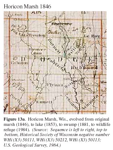
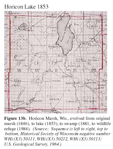
Example of Changing Attitudes--horicon marsh | |||
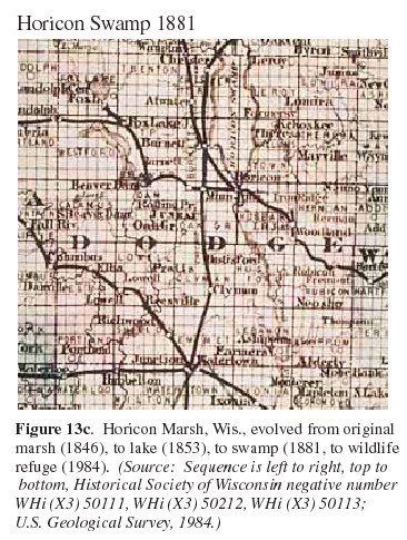
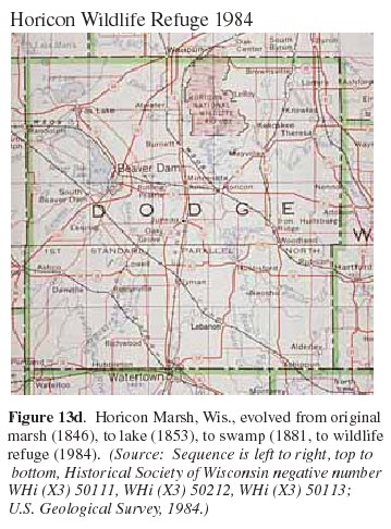
| The history of the Horicon Marsh in Wisconsin is an example of how people's attitudes toward wetlands have changed through time (fig. 13). Horicon Marsh was dammed, flooded, and renamed Lake Horicon in 1846. At that time, it was the largest manmade lake in the world (about 4 miles wide by 14 miles long) (Wisconsin Department of Natural Resources, 1990). Lake Horicon was used for commercial transportation and for commercial fishing. In 1869, the dam was removed and the land returned to marsh. In 1883, two sportsmen's clubs, which leased the marsh area, reported that 500,000 ducks hatched annually in the marsh. They also reported that 30,000 muskrats and mink were trapped in the southern half of the marsh. Huge flocks of geese also were reported (Freeman, 1948). In 1904, attempts were made to drain the marsh and sell the reclaimed land for truck farms. Lawsuits resulting from inadequate drainage halted the reclamation effort. |
In 1921, local conservationists began efforts to protect Horicon Marsh as
a game refuge, and the State of Wisconsin created the Horicon Marsh
Wildlife Refuge in July 1927. Later, to avoid legal confrontations with
the local farmers, the State bought property and (or) water rights to the
southern half of the refuge and the Federal Government purchased rights to
the northern half. In 1990, Horicon Marsh was added to the sites
recognized by the Convention on Wetlands of International Importance
especially as Waterfowl Habitat. Estimates indicate that today slightly more than 100 million acres of wetlands remain in the conterminous United States. Although the rate of wetland conversion has slowed in recent years, wetland losses continue to outdistance wetland gains. |
| |
| |||
References Cited | ||
|
| |
|
Thomas E. Dahl, National Wetlands Inventory, 9720 Executive Center Drive, Suite 101 - Monroe Building, St. Petersburg, FL 33702 |
Gregory J. Allord, U.S. Geological Survey, 505 Science Drive, Madison, WI 53711 |