
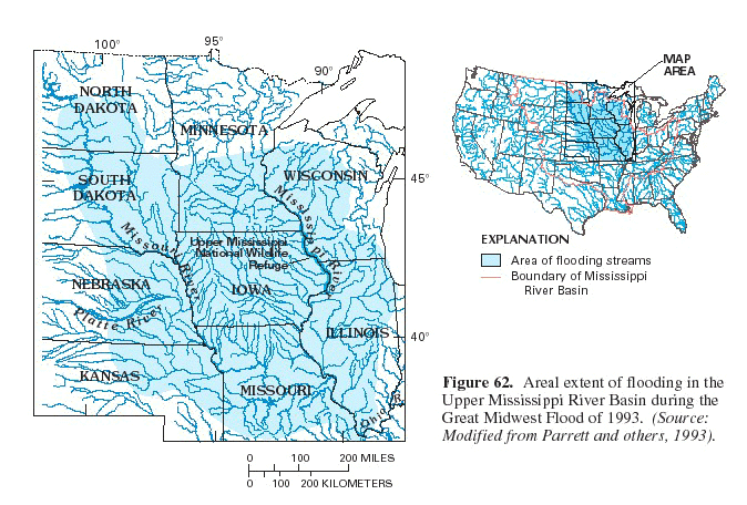
Significant flooding in the Upper Mississippi River Basin began in mid-June and persisted into early August 1993. The areal extent of this flooding included southern Minnesota, southwestern Wisconsin, Iowa, western Illinois, northern Missouri, southern North Dakota, and eastern parts of South Dakota, Nebraska, and Kansas (fig. 62).
Record flood-peak discharge was recorded at 39 streamflow-gaging stations in the Upper Mississippi River Basin. Fifteen other gaging stations recorded peak discharges exceeding previous maximum known regulated discharges (Parrett and others, 1993). The recurrence interval of the peak discharge at 40 stations exceeded the 100-year flood (one-percent chance of occurring in any given year).
Near-record and record precipitation in June and July, falling on soil already saturated by as much as twice normal early spring rains, caused these record floods. Precipitation for the period January-July 1993 totaled more than 20 inches in most of the flooded area and more than 40 inches in parts of northeastern Kansas and east-central Iowa (Wahl, Vining, and Wiche, 1993). Many areas received more precipitation in those 7 months than is normally received during the entire year.
The Great Midwest Flood of 1993 was unique not only because of the record high water levels and flows and the wide areal extent, but also because of the long duration of flooding.Many rivers were above flood stage for several months. The long period of inundation had significant effects on agricultural land and wetlands.
 (Click on image for a larger version.) |
| Figure 62. Areal extent of flooding in the Upper Mississippi River Basin during the Great Midwest Flood of 1993. (Source: Modified from Parrett and others, 1993). |
The flood effects on wetlands varied in both the short term and long term. In the Upper Mississippi National Wildlife Refuge, the flooding lasted 14 weeks-from April through mid-August. "This prolonged inundation of bottom-land hardwood forest and backwater wetlands caused many tree tip-overs, scoured out ground cover and tree regeneration sites, eroded islands, destroyed emergent/submergent vegetation beds, impacted project dikes, and thus destroyed most of the moist soil plants at three sites," according to James Lennartson of the U.S. Fish and Wildlife Service. The effects on wildlife populations also were severe. Many birds, including green-backed herons and red-shouldered hawks, fledged few young due to flooded foraging areas. Substrate disturbance and massive sedimentation saffected freshwater mussel populations. Mussels were found buried by 1 to 2 feet of sand. Mammals were displaced from the flood plain and suffered higher than normal mortality rates on adjacent roads and railroad tracks (James Lennartson, U.S. Fish and Wildlife Service, written commun., 1994). Fishes that rely on sight to find their food were handicapped because of the increased turbidity.
The flooding, however, had some short-term benefits. Many fish feed and spawn on inundated flood plains. "Ideal conditions for spring spawning fishes occur during years in which flood and temperature rise are coupled" (Scientific Assessment and Strategy Team, 1994). The evidence, particularly in the lower Missouri River flood plain, "***indicates that the magnitude and timing of the 1993 flood provided appropriate temperature and discharge cues for spawning river-floodplain fishes" (Scientific Assessment and Strategy Team, 1994).
...the "most devastating flood in modern United States history"...
...a historically unprecedented hydrometeoro- logical event...
Wetlands commonly mitigate the effects of floods. Wetland areas can be filled with and temporarily store floodwaters so that flood effects on agricultural and residential areas are lessened. However, wetlands have been steadily dissappearing or converted to other uses throughout the flood-affected area for the last two centuries (see "History of Wetlands in the Conterminous United States" in this volume). These wetlands include the river flood plains and the upland prairie potholes.
Many upland prairie pothole wetlands are closed flow systems, which fill with rain and melting snow and then slowly evaporate or drain through the ground-water system. Thus, they areideal retention basins during and after intense rains because they "do not normally contribute to stream flow byrunoff, except during storms large enough to make the depressions fill and spill"(Scientific Assessment and Strategy Team, 1994). This seems to have been the case in the flood of 1993. All available storage capacity of the wetlands was exceeded, and usually noncontributing areas did contribute to runoff (Interagency Floodplain Management Task Force, 1994). In modeling done by the Scientific Assessment and Strategy Team (1994), upland wetlands simulated decreased flooding in a 1-year event by 9-23 percent, but only by 5-10 percent in a 100-year event. Flood-plain wetlands decreased flooding 5-6 percent for 1-year floods and only 2-3 percent for the 100-year storms.
 (Click on image for a larger version, 77K) |
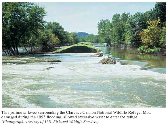
| This perimeter levee surrounding the Clarence Cannon National Wildlife Refuge, Mo., damaged during the 1993 flooding, allowed excessive water to enter the refuge (Photograph courtesy of U.S. Fish and Wildlife Service). |
The Executive Summary of the Report of the Interagency Floodplain
Management Review Committee to the Administrative Floodplain Management
Task Force (1994) states the effect that wetlands had on the Great Midwest
Flood of 1993:
The loss of wetlands and upland cover and the modification of the landscape throughout the basin over the last century and a half significantly increased runoff. *** Although upland watershed treatment and restoration of upland and bottom-land wetlands can reduce flood stages in more frequent floods (25 years and less), it is questionable whether they would have significantly altered the 1993 conditions (Interagency Floodplain Management Task Force, 1994).In conclusion, the Great Midwest Flood of 1993 was a historically unprecedented hydrometeorological event in area affected, severity of the effects, and duration of the effects. Wetlands were affected beneficially and detrimentally in the short and long term. The historical loss of wetlands from the basin increased the severity of the flood, but even if all presettlement wetlands had still existed,the flood would probably still have set records and caused billions of dollars in damages.
(Click on image for a larger version, 48K) |
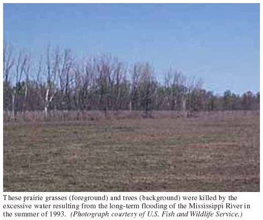
| These prairie grasses (foreground) and trees (background) were killed by the excessive water resulting from the long-term flooding of the Mississippi River in the summer of 1993. (Photograph courtesy of U.S. Fish and Wildlife Service). |
References Cited
- Interagency Floodplain Management Task Force, 1994,
-
Report to the Administration Floodplain Management Task Force-Sharing the
Challenge: Floodplain Management into the 21st Century, 191 p.
- National Oceanic and Atmospheric Administration, 1994,
-
Natural disaster survey report, The Great Flood of 1993, [281 p.].
- Parrett, Charles, Melcher, N.B., and James, R.W., Jr., 1993,
- Flood disharges in the Upper Mississippi River Basin, in Floods in the Upper Mississippi River Basin, 1993: U.S. Geological Survey Circular 1120-A, 14 p.
- Scientific Assessment and Strategy Team, 1994,
- Preliminary report to the Interagency Floodplain
Management Review Committee of the Administration Floodplain
Management Task Force-Science for floodplain management into the 21st
century.
- Wahl, K.L., Vining, K.C., and Wiche, G.J., 1993,
- Precipitation in the Upper Mississipi River Basin-January 1 through July 31, 1993, in Floods in the Upper Mississippi River Basin, 1993: U.S. Geological Circular 1120-B, 13 p.
For Additional Information:
James R. Kolva,U.S. Geological Survey,
Utah District,
1745 West 1700 South,
Salt Lake City, UT 84104