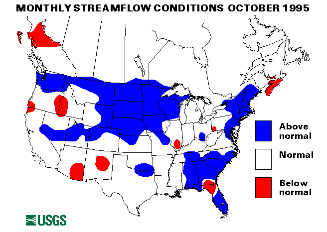
Hurricane Opal moved ashore in western Florida on October 4. By October 5, the storm was in southeastern Tennessee and then moved into central Ohio. In many places in the Southeastern United States, heavy rain from a frontal system preceeded Opal, and caused flash flooding and river flooding. Birmingham, Alabama, received 9.96 inches of rain from October 3 to 4. Most of Georgia received from 4 to 6 inches of rain on October 5. Evacuations owing to flash floods were necessary around Atlanta, Georgia, and in the mountains of North Carolina. Further north, the flooding was less severe owing to previous dry conditions that allowed much of the rain to infiltrate into the ground-water system. In Alabama, North Carolina, and Georgia, however many rivers and streams exceeded flood stages; some peak flows were around a 25-year recurrence interval.
Hurricane Roxanne caused heavy rains and some flash flooding in Coastal Texas on October 13. Rainfall totals of as much as 4 inches were recorded in some localities.
Flooding was continuous in South Florida for the entire month of October. A stationary weather front produced nearly daily rainfall totals of 3-4 inches. During the week of October 15-21, Jupiter, Florida, received about 20 inches of rain, which included 9.13 inches in 24 hours on October 17. Port Salerno, Florida, received 8.25 inches of rain between 11:15 am and 3:00 pm on October 18. Flooding was particularly noteworthy in Lee County and along the Withlacoochee River. Evacuations were necessary in many areas, and because of the continued rainfall, streams remained above flood stage for extended periods.
Only one index streamflow-gaging station recorded new maximum October monthly mean flows. The Buffalo River near Dilworth, Minnesota, had a monthly mean of 200 cubic feet per second, which is 537 percent of the October long-term median.
The combined flow of the three largest rivers in the lower 48 States-- the Mississippi, the St. Lawrence, and the Columbia--seasonally increased 6 percent from last month to 680,200 cubic feet per second, which is 98 percent of the long-term October median and in the normal range. The Columbia River flow at The Dalles, Oregon, increased 17 percent from the September mean and is 122 percent of median flow.
![]() U.S. Department of the Interior |
U.S. Geological Survey
U.S. Department of the Interior |
U.S. Geological Survey
URL: https://water.usgs.gov/nwc/back_issues/oct95_cov.html
[an error occurred while processing this directive]
Page Contact Information: Water Webserver Team
Page Last Modified: Friday, 08-Jun-2007 16:38:19 EDT
URL: https://water.usgs.gov/nwc/back_issues/oct95_cov.html
Page Contact Information: NatWeb Team (GS_Help_Natweb@usgs.gov)
Page Last Modified: Friday, 08-Jun-2007 16:38:19 EDT