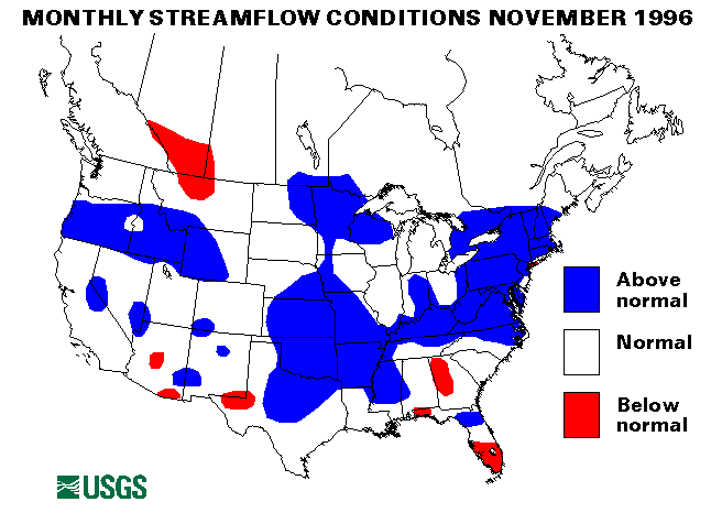
On November 7, heavy rainfall of 2 to 4 inches caused flash flooding in parts of Texas, Oklahoma, Arkansas, and Missouri. The most significant flooding was in Oklahoma, along Polecat Creek from Sapulpa to Jenks; flooding was moderated along Bird Creek. Flooding of agricultural lowlands in LeFlore County along the Poteau River continued until November 8. On November 16, more than 4 inches of rain fell in southwestern Missouri and northern Oklahoma. Widespread flash flooding was closed many roads throughout this area. On November 24 heavy rains from a strong cold front caused major flooding in Oklahoma and flash flooding in Arkansas, Texas, and Louisiana, rainfall totaled as much as 6 inches in Oklahoma, the Poteau River at Poteau, and Panama, reached record crests; was flooding moderated along the Illinois, the lower Arkansas, and the Red Rivers. In Ellis County, Texas, rainfall rates were estimated to be 3 inches per hour. The Buffalo River near St. Joe, Arkansas, index station set a maximum monthly mean for November with a flow of 6,446 cubic feet per second (ft3/s) which was 2,286 percent of the long-term (1961-90) median.
New York and New England Region
A slow-moving cold front dropped from 3 to 6 inches of rain in central New York on November 8-9. The result was widespread flooding in the Catskills and the Adirondacks. Record peaks were recorded on the Au Sable River at Au Sable Forks, and the Saranec River at Plattsburgh. Bridges were washed out, and a low-head dam failed in Ellenburg Center, which caused flooding along the North Branch of the Great Chazy River.
Mid-Atlantic Region
Near Wellsboro, Pennsylvania heavy rains of from 3 to 5 inches on November 8 caused serious flooding. Roads were still under water on November 9.
Streamflows at the index-gaging stations on the Potomac River near Washington, D. C., the Choptank River near Greensboro, Maryland, and Seneca Creek at Dawsonville, Maryland, have been above normal for 7 months, 8 months, and 8 months, respectively. The Potomac River station had a November mean flow of 22,100 cubic feet per second (ft3/s) which was 434 percent of the long-term median flow for November.
Northern Mid-Continent Region
On November 16, heavy rainfall of up to 4 inches fell across parts of Russell and Barton Counties, Kansas. Small streams flooded low- lying areas. Record maximum November mean monthly flows was set two streamflow index stations, the Saline River near Russell, Kansas, and the Little Blue River near Barnes; the Saline River flow was 247 cubic feet per second (ft3/s), 1,658 percent of the November median.
The Elkhorn River at Waterloo, Nebraska, has been above normal flow for 7 consecutive months. The November flow was 1,854 cubic feet per second (ft3/s), which was 279 percent of the long-term November median flow.
Northwest Region
Widespread flash flooding was caused by heavy rains in western Oregon on November 18. Most of the area received more than 4 inches of rain; 6.47 inches were reported at Gold Beach. The flooding was aggravated by warmer temperatures and melting snow. Most mountain streams were above- bank full stage. Many roads were closed by mudslides. The Mohawk River crested at a level higher than that reached during the floods in February 1996.
More heavy rain on November 27-28 caused minor flooding in western Washington and Oregon. Quillayute, Washington, recorded 6.40 inches and Astoria, Oregon, 4.80 inches. The Cedar, the Snohomish, the Skokomish, the Tolt, the Puyallup, and the Chehalis Rivers in Washington were over flood stage.
Puerto Rico
Heavy rainfall over northern Puerto Rico caused flash flooding on November 22. More than 5 inches fell in 3 hours. Both streamflow-index stations were in the normal flow range for the month.
Mid-South Region
The November mean flow of the Ohio River at Louisville, Kentucky, was 165,000 cubic feet per second (ft3/s) which was 247 percent of the long-term median. Flow at this station has been above normal for 7 consecutive months.
Atlantic Southeast Region
Streamflows at the index-gaging stations on the Rappahannock River at Remington, Virginia, and the Potomac River at Paw Paw, West Virginia, have been above normal for 6 months and 7 months, respectively. The Potomac River Basin area has been extremely wet for most of 1996.
Alaska
Three of the four streamflow-index stations in Alaska were below normal in November. The exception was the Chena River at Fairbanks, which had normal flow.
Hawaii
The index station on Honopou Stream near Huelo, Maui, was in the normal-flow range. Above-normal flows were reported on the East Branch of the North Fork of the Wailua River near Lihue, Kauai, and on Kalihi Stream near Honolulu, Oahu.
Big Three Rivers
The combined flow of the three largest rivers in the lower 48 states-- the St. Lawrence, the Mississippi, and the Columbia--increased 29 percent from last month to 1,008,560 cfs which is 134 percent of the long-term November median and above-normal. The Mississippi River at Vicksburg, Mississippi, increased 53 percent from October to 166 percent of median. The St. Lawrence flow is also above-normal at 111 percent of median.
![]() U.S. Department of the Interior |
U.S. Geological Survey
U.S. Department of the Interior |
U.S. Geological Survey
URL: https://water.usgs.gov/nwc/back_issues/nov96_cov.html
[an error occurred while processing this directive]
Page Contact Information: Water Webserver Team
Page Last Modified: Friday, 08-Jun-2007 16:38:13 EDT
URL: https://water.usgs.gov/nwc/back_issues/nov96_cov.html
Page Contact Information: NatWeb Team (GS_Help_Natweb@usgs.gov)
Page Last Modified: Friday, 08-Jun-2007 16:38:13 EDT