Provisional data subject to review.

Conditions for the month of January 1997
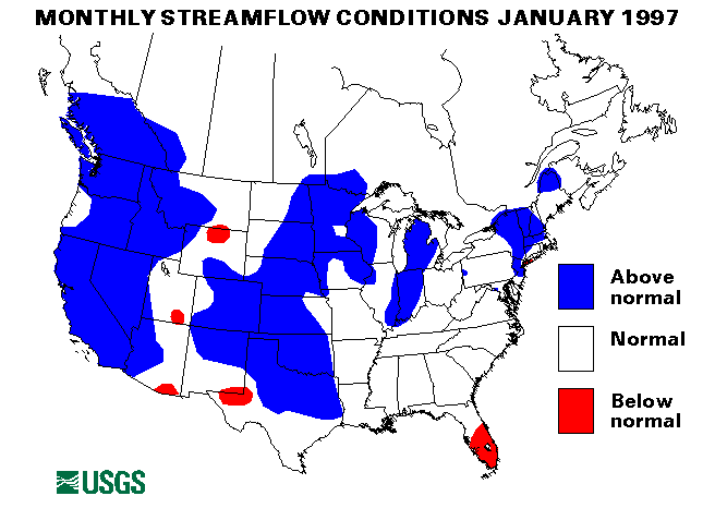
Southwest Region
Extreme flooding continued in central and northern California and western
Nevada in January. Record peak flows were recorded on the Truckee,
Walker, and Carson Rivers in Nevada, and the Russian and Napa Rivers in
California. Numerous levees failed in California causing widespread areas
of inundated land along the Cosumnes, Mercer, Feather, Toulumne, and San
Joaquin Rivers. Thousands of people had to be evacuated, highways were
closed, and even the Reno International Airport was closed due to flood
waters. Yosemite National Park was closed and visitors had to be
evacuated. Further information and details of the flooding are available
at
Nevada and
Northern California . Rainfall
totals for the first week of January were up to 25 inches in some
locations. The Carson River near Dayton, Nevada, changed its course and
destroyed several homes on January 6.
After flooding had subsided somewhat, another storm on January 23 dumped
up to 5-6 inches of rain on northern and central California which brought
many creeks and streams again to flood conditions. The Napa, Russian,
Cosumnes, and Merced Rivers saw sharp rises. The storm also hit the
flooded areas of Nevada and again caused small stream flooding and
aggravated the continuing large river flooding.
Blue Canyon, California, has received 77.06 inches of rain from December
1 to January 25. This amount is 123 percent of the normal annual rainfall
for that site.
New maximum January mean monthly flows were set at four streamflow index
stations in California and one in Nevada. They are the West Walker River
below Little Walker River near Coleville, California, 1807 percent of the
long-term (1961-90) median; the North Fork American River at North Fork
Dam, California, 1251 percent; Sacramento River at Verona, California,
353 percent; the Merced River at Happy Isles Bridge near Yosemite,
California, 1274 percent; and the Humboldt River at Palisades, Nevada,
467 percent.
Northwest Region
New Year's Day saw continued flooding across much of Oregon and
Washington. The Nehalem River at Nehalem, Oregon crested over 8 feet
above flood stage. Flooding was generally moderate in Washington. Severe
flooding was experienced on the Umatilla River near Pendleton, Oregon.
The Willamette River basin only had moderated flooding. The Bear Creek in
Medford, Oregon, did set a new all-time peak flow with 16,100
cubic feet per second (ft3/s) on January 1.
Intermountain West Region
The Weiser, Idaho, area had severe flooding on January 1-5. The Weiser
River crested at record levels nearly 7 feet above flood stage on January
2. Some levees failed and evacuations were necessary.
Snowmelt caused by above normal temperatures caused ice jams and flooding
on the Musselshell and Yellowstone Rivers in Montana on January 3. The
Little Salmon River in Montana also had snowmelt and ice jam flooding
from January 1-4.
New maximum January monthly mean flows were established at three
streamflow index sites in Idaho, one in Montana, and one in Wyoming. They
are the Snake River near Heise, Idaho; the Snake River at Weiser, Idaho;
the Salmon River at White Bird, Idaho; the Yellowstone River at Corwin
Springs, Montana; and the North Platte River above Seminoe Reservoir near
Sinclair, Wyoming.
Mid-South Region
Heavy rainfall of more than 3 inches in one hour caused flash flooding in
Marshall County, alabama, on January 5.
Heavy rains on January 9-13 caused minor river flooding in Alabama and
Mississippi. Agricultural flooding was experienced along the Big Black
River near Bentonia, Mississippi when the river crested about one foot
over the flood stage.
Rainfall of 1.5 inches or more on January 24 caused flash flooding in
Bledsoe, Marion, and Sequatchie Counties in Tennessee.
Mid-Continent North Region
Snowmelt and ice jams caused flooding problems along the Missouri River
at Williston, North Dakota, from January 8-13.
A new maximum January monthly mean flow was established at the streamflow
index station on the Bad River near Fort Pierre, South Dakota.
Atlantic Southeast Region
Flash flooding resulted after 3 to 5 inches of rain fell on January 14 in
Broward and Palm beach Counties, Florida.
The streamflow index station on Fisheating Creek at Palmdale, Florida has
been below-normal for the last six months. Flow in January was only 15
percent of the long-term median.
New England and New York Region
An ice jam on the St. Regis River near Bresher Falls, Vermont, caused
localized flooding problems on January 14.
On January 23, warm temperatures and snowmelt caused ice jam flooding on
Muddy Creek in Madison County, New York.
Eastern Great Lakes Region
An ice dam caused by wind-pushed lake ice caused flooding along the
Chocolay River in Marquette County, Michigan, on January 21.
Rainfall and snowmelt caused lowland flooding in Indiana and Illinois
from january 23-30. The ground was frozen in much of this area forcing
all the rain and snowmelt to runoff. The wabash River in Indiana and
Illinois and the White River in Indiana were most affected. This flooding
caused the Ohio River downstream of the Wabash River confluence to also
rise slightly above flood stage.
In Ohio, ice jams caused minor flooding along the Walhonding River near
Warsaw on January 24. These jams persisted through January 29.
Ice jams on January 28 caused the Wabash River near Lafayette and
Covington, Indiana, to rise to 4 feet above flood stage, causing some low
land flooding.
Mid-Atlantic Region
On January 24, ice jams along French Creek, Oil Creek, and the Allegheny
River in western Pennsylvania caused some minor flooding. Ice jams
remained a problem on the Allegheny River through January 29.
The index gaging station on Seneca Creek near Dawsonville, Maryland, has
been above-normal flow for ten consecutive months. January 1987 flow was
175 cfs, which is 164 percent of the long-term median.
Alaska
Two streamflow index stations in Alaska were below-normal flow in January
and two were in the normal rang. The Kenai River at Cooper Landing,
Alaska, and the Tenana River at Nenana, Alaska were below-normal at 52
and 89 percent of median, respectively.
Hawaii
One of the three reporting streamflow index stations in Hawaii was
above-normal, the others were in the normal range. The East Branch of
North Fork Wailua River near Lihue, Kauai, Hawaii, was at 209 percent of
the long-term January median.
Puerto Rico
Both streamflow index stations in Puerto Rico were above-normal in
January. A new maximum January monthly mean flow was set at Rio Grande de
Manati at Highway 2 near Manati, Puerto Rico, at 912 cubic feet per second (ft3/s), which is 434
percent of median for January.
Big Three Rivers Combined Flow
The combined flow of the three largest rivers in the lower 48 states--
The St. Lawrence, the Columbia and the Mississippi--decreased by 13
percent from last month to 1,095,000 cubic feet per second (ft3/s).
this flow is 117 percent of the
long-term January median and in the normal range.