Flash flooding occurred in Pennsylvania, after 3 to 5 inches of rain fell on August 8. At least 20 homes were flooded, near Pittsburg Pennsylvania, and evacuations were necessary. Hamilton County, New York, and Hampshire County, Massachusetts, were deluged with more than 4 inches of rain on August 27 which caused major street flooding in Northampton, Massachusetts. Tributaries of the Mill River at Northampton, Massachusetts were above flood stage.
Southeast Region
Paducah, Kentucky, recorded only 0.11 inches of rain for an August record low. Flash flooding occurred in West Virginia, on August 8. Rainfall totalled up to 3 to 5 inches. Potomac River at Paw Paw, West Virginia, set a record high for the month of August. Significant flash flooding hit Caldwell County, North Carolina, on August 11 and 12. Rainfall totalled up to 7 to 9 inches. Several bridges along Wilson Creek were washed out, stranding vehicles and requiring some evacuations. In Georgetown and Horry Counties, South Carolina, 8 inches of rain on August 27 caused widespread flash flooding, and at least one individual had to be rescued from his home by boat.
Great Lakes Region
Although Dayton, Ohio, recorded a record low for any month with only 0.03 inches of rain, Streamflow conditions were near normal because of fairly high base-flow conditions after the very wet spring, and also the temperatures have been below normal this summer in this area. Ohio and western Pennsylvania received torrential rainfall with as much as 4 inches per hour on August 20, causing some small creeks and streams to flood. Owen County, Ohio, received another storm in excess of 3 inches on August 27.
Mid-Continent Region
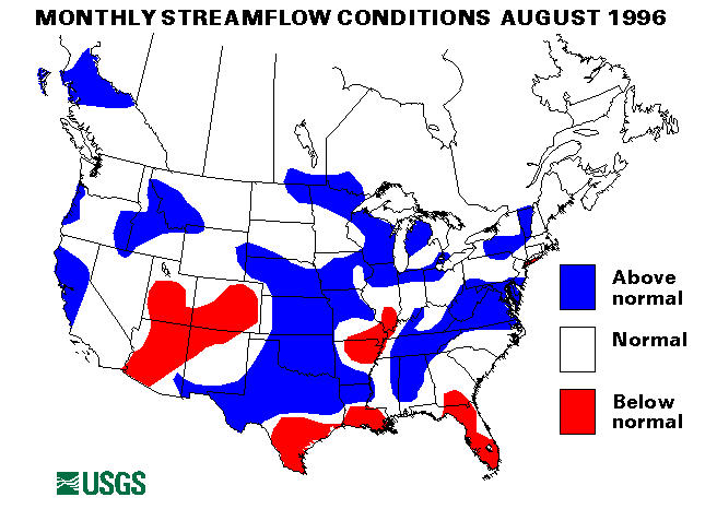
Drought conditions in the Southwestern United States improved during August. Because of rainfall from the remnants of Hurricane Dolly and other rains later in the month. Corpus Christi, Texas, recorded 8.57 inches of rain in August--the third wettest August on record. On August 19-20, over 3 inches of rain in parts of Texas caused flash flooding. On August 24-30, Isolated rainfall totals of 6 to 8 inches were reported. Flash flooding caused many road closures and some evacuations. General rainfall amounts of 2 to 4 inches were measured in north Texas. A small bridge was washed out west of Toyah, Texas, on August 25. Heavy rains caused flash flooding and river flooding in Nebraska, Kansas, Iowa, and Missouri, from August 2 to 12. Orleans, Nebraska, measured 2.4 inches of rain in 30 minutes on August 2. Sheridan County, Nebraska, received as much as 6 inches of rain in 4 hours on August 3. The most significant flooding was along the Elkhorn River in Nebraska. Pebble Creek, a tributary of the Elkhorn River, set a new peak record at Scribner, Nebraska, at 11.6 feet above flood stage. Record stage was also recorded on Maple Creek at Nickerson, Nebraska. The Elkhorn River at Waterloo, Nebraska, an index-streamflow station, set a new maximum August mean flow. On August 6, Rawlins County, Kansas, received as much as 6 inches of rain in 3 hours. All these heavy rainstorms caused the Missouri River to exceed flood stage from Plattsmouth, Nebraska, downstream through Miami, Missouri. Another round of heavy rainfall hit Iowa, Nebraska, Kansas, Oklahoma, and Missouri from August 19 through 26. Lincoln, Ford, Pawnee, and Edwards Counties in Kansas reported up to 5 inches on August 19 causing widespread flash flooding. Atchison and Holt Counties, Missouri, also reported 3 to 5 inches of rain on that date causing the Tarkio River to flood. On August 22, Furnas County, Nebraska, received rainfall up to 5 inches causing rapid rises on Beaver and Sappa Creeks. Heavy rainfall in the Kansas City, Kansas, area temporarily closed Interstate 70. Cimarron County, Oklahoma, received as much as 4 inches of rain with rates of 2 inches per hour which caused serious flash flooding. On August 26, West Des Moines, Iowa, reported 3 inches of rain in 3 hours. All these heavy rainfall events caused widespread flash flooding, and runoff brought the Missouri River back over flood stage from Brownville, Nebraska, to St. Joseph's, Missouri.
Western Region
On August 19-20, over 3 inches of rain in parts of New Mexico caused flash flooding. On August 24-30, Isolated rainfall totals of 6 to 8 inches were reported, flash flooding caused many road closures and some evacuations. On August 29, Cheyenne, Wyoming, received 7 inches of rain which caused flash flooding. Some roads were covered with 4.5 feet of water. Hot and dry conditions in the Intermountain West, California, the northern Plains, and the Northwest spread drought conditions into these areas. By August 29, wildfires had burned more than 5 million acres--more than in 1988 (the year of the Yellowstone fires) and about 270 percent of the 5-year normal.
Alaska, Hawaii, and Puerto Rico
Flows at index-stramflow gages in Alaska were normal or below-normal range. The Little Susitna River near Palmer, Alaska, set a new record-low monthly mean for August. The Tanana River at Nenana was also below the normal range. Flows at index-streamflow gages in Hawaii were normal or below normal. The Honopou Stream near Huelo, Maui, Hawaii, was below normal. Both index gages in Puerto Rico were in the normal range.
The combined flow of the three largest rivers in the lower 48 states--
the St. Lawrence, the Mississippi, and the Columbia--declined seasonally 21 percent from last month to 926,600 cubic feet per second. This flow is 119 percent of the long-term median flow for August and in the above-normal range. The Columbia River at The Dalles, Oregon, declined 56 percent from July but was still at 105 percent of median flow.
![]() U.S. Department of the Interior |
U.S. Geological Survey
U.S. Department of the Interior |
U.S. Geological Survey
URL: https://water.usgs.gov/nwc/back_issues/aug96_cov.html
[an error occurred while processing this directive]
Page Contact Information: Water Webserver Team
Page Last Modified: Friday, 08-Jun-2007 16:37:20 EDT
URL: https://water.usgs.gov/nwc/back_issues/aug96_cov.html
Page Contact Information: NatWeb Team (GS_Help_Natweb@usgs.gov)
Page Last Modified: Friday, 08-Jun-2007 16:37:20 EDT