On April 1-3, Victoria, Texas, received a total of 9.89 inches of rain. Other parts of Texas reported 10-13 inches of rain. This heavy rainfall caused record peak flows on the Salt Fork of the Red River near Wellington, Texas. Widespread flash flooding was reported across the state. Shreveport, Louisiana, recorded 7.81 inches of rain on April 4-5. Magnolia, Arkansas, received 11.73 inches and Sarepta, Louisiana, 10.40 inches/nover this same period. Flash flooding problems again were widespread.
A record flood peak was measured at Bayou Dorcheat at Springhill, Louisiana, following nearly 11 inches of rain on April 5-6. The crest was 23.8 feet, over 1 foot above the previous record flood. On April 10, the station at Dixie Inn crested at 25.6 feet, 0.7 feet above the previous record and 11.6 feet above flood stage.
Overnight on april 10-11, up to 12 inches of rain fell in parts of Lavaca County, Texas, East Mustang Creek rose more than 14 feet in less than 8 hours. Evacuations and sever flash flooding were experienced as well as major flooding along the Lavaca River and Big Brush Creek.
4-8 inches of rain in the Houston, Texas, area caused significant flash flooding on April 25. Up to 9 inches of rain in a 9-hour period caused flash flooding in Feliciana Parish, Louisiana, on April 27. The Tickfaw River near Liverpool, Louisiana, flooded roads and residences when it crested 4 feet above flood stage on April 28.
Two streamflow index stations in Texas, the North Bosque River near Clifton, Texas, and the North Concho River near Carlsbad, Texas, have had above-normal flows for 9 and 6 months, respectively. The North Bosque River was 1217 percent of median for April.
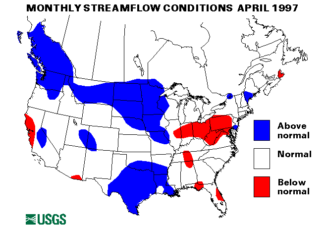
Mid-Continent North RegionA severe blizzard across North Dakota, South Dakota, and Minnesota aggravated the existing flooding conditions with ice jams and frozen overflow areas during the first week of April. The Souris and James Rivers in North Dakota and the James and Vermillion Rivers in South Dakota were most affected. Record flooding was measured along most of the James River. At Huron, South Dakota, the stage was almost 3 feet above the old record, overtopping levees. Record stages were also set at Forestburg, Mitchell and near Columbia, South Dakota. More information on floods in South Dakota.
Record flooding on the Red River of the North in North Dakota and Minnesota began about April 7 and continued to the end of the month. Grand Forks, North Dakota, and East Grand Forks, Minnesota, were hardest hit. The Red River crested at Fargo, North Dakota, on April 12 over 20 feet above flood stage. Dikes protecting Grand Forks and East Grand Forks gave way on April 18. Both cities had to be almost totally evacuated. The Red River crested at around 54 feet at Grand Forks on April 23, over 5 feet above the previous record, and 25 feet above flood stage. These floods on the Red River were estimated to be between 100-year and 500-year recurrence interval floods. More information on floods in North Dakota and Minnesota District web pages.
The index gaging station on the Red River of the North at Grand Forks, North Dakota set a new record mean April monthly flow of 56,810 cubic feet per second cubic feet per second cubic feet per second (ft3/s), which was 572 percent of the long-term (1961-90) median flow for April.
AlaskaKodiak, Alaska, set record 24-hour rainfall for the month of April twice. On April 4, 2.92 inches fell, but this record only lasted 5 days before being surpassed bay 2.99 inches on April 9.
Two of the three reporting streamflow index stations in Alaska had normal flows in April. The Little Susitna River near Palmer, Alaska, was above-normal at 135 percent of the long-term April median.
Western Great Lakes RegionBesides the flooding along the Red River (see the Mid-Continent North Region) high water was also experienced along the Minnesota, Redwood and Mississippi Rivers in Minnesota during April. Flooding was moderate along the Mississippi River from St. Cloud, Minnesota, south to Thebes, Illinois. Crest dates ranged from April 9 at St. Cloud to April 23 at Thebes.
Three streamflow index gaging stations in Minnesota set new maximum April mean monthly flows. The Buffalo River near Dilworth, Minnesota, 669 percent of long-term median, the Mississippi River near Anoka, Minnesota, 244 percent, and the Minnesota River near Jordan, Minnesota, 505 percent, all measured records.
New York-New England RegionHeavy rainfall on April 19-20 of over 4 inches caused localized flooding in Cumberland and York Counties, Maine, and Carroll and Strafford Counties, New Hampshire.
Intermountain West RegionWarm temperatures causing snowmelt and rainfall caused streams in Idaho and Montana to rise to bankfull or slightly above flood stage from April 22-30. The St. Joe and Couer D'Alene Rivers were most affected. The Portneuf River at Pocatello, Idaho, peaked 1.5 feet over flood stage on April 25.
The flows of three index streamflow stations have been above normal for six consecutive months. These stations are the Snake River near Heise, Idaho; the Salmon River at White Bird, Idaho; and the Yellowstone River at Corwin Springs, Montana.
Southeast Atlantic RegionDry conditions were present across the southeast through the middle of April. March 1 to April 19 precipitation was only 19 percent of normal in Macon, Georgia, 30 percent in Athens, Georgia, and 42 percent in August, Georgia. Rainfall the last two weeks of April did ease the dry conditions somewhat.
Heavy rains on April 26 of as much as 10 inches fell in Dade County, Florida. Flash flooding and street flooding was widespread.
Thunderstorms with rainfall rates up to an inch an hour drenched parts of North Carolina on April 29. The Rock River crested 8-9 feet over flood stage causing considerable lowland flooding. Serious flooding was also experienced along the Tar River on April 30.
Mid-South RegionHeavy thunderstorms on April 27 dropped 5 inches of rain in less than 12 hours flooding streets in Pike County, Mississippi. Some evacuations were necessary.
Southwest RegionA new maximum April mean monthly flow was established at the streamflow index station on the West Walker River below Little Walker River near Coleville, California. This station and the index station on the Merced River at Happy Isles Bridge, near Yosemite, California, have both been above-normal for six consecutive months.
Northwest RegionThe flow of the John Day River at Service Creek, Oregon, has been above normal for six consecutive months.
HawaiiTwo of the three reporting streamflow index stations in Hawaii had normal flows in April. Kalihi Stream near Honolulu, Oahu, Hawaii, was above-normal with 249 percent of April median.
Puerto RicoBoth index streamflow sites in Puerto Rico had below-normal flows in April. The Rio Grande De Manati at Highway 2, near Manati, Puerto Rico was only 33 percent of median. The Rio Inabon at Real Abajo, Puerto Rico, was 61 percent of April median flow.
Big Three RiversThe combined flow of the three largest rivers in the lower 48 states-- the St. Lawrence, the Mississippi, and the Columbia--decreased 7 percent from March to 1,814,000 cubic feet per second cubic feet per second (ft3/s),. This flow is 125 percent of the long-term April median and above normal. The St. Lawrence River at Cornwall, Ontario, near Massena, New York, has had above-normal flows for six consecutive months.
![]() U.S. Department of the Interior |
U.S. Geological Survey
U.S. Department of the Interior |
U.S. Geological Survey
URL: https://water.usgs.gov/nwc/back_issues/apr97_cov.html
[an error occurred while processing this directive]
Page Contact Information: Water Webserver Team
Page Last Modified: Friday, 08-Jun-2007 16:37:14 EDT
URL: https://water.usgs.gov/nwc/back_issues/apr97_cov.html
Page Contact Information: NatWeb Team (GS_Help_Natweb@usgs.gov)
Page Last Modified: Friday, 08-Jun-2007 16:37:14 EDT