Heavy rainfall on April 10--11 caused significant flooding in the central gulf coast region. Leesville and Baton Rouge, Louisiana, recorded more than 7 inches of rain, and locally, amounts more than 13 inches were recorded. The Tickfaw, the Amite, the Comite, and the Calcasieu River Basins flooded insouthern Louisiana.
Minor flooding owing to heavy rainfall occurred in the Midwest, most notably in Illinois, Indiana, and northwestern Ohio during the week of April 10--15. In South Dakota, the James River was above flood stage most of the month with record high stages recorded at stations at Forestburg and Mitchell, and the Vermillion and the Big Sioux Rivers also had some minor flooding.
Flash floods owing to heavy downpours from local thunderstorms in many areas. On April 20, flash floods were reported in Alabama, Mississippi, Kentucky, and Indiana. More flash floods occurred on April 24 in Louisiana, Mississippi, and Texas. Evacuations were necessary in the Shreveport, Louisiana, area, and a mudslide blocked a highway near Vicksburg, Mississippi. Urban and small-stream flooding occurred northeastern Illinois and southeastern Wisconsin on April 27.
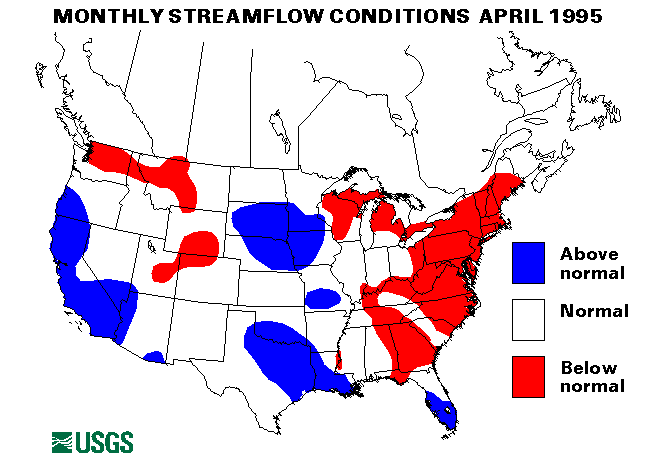
In contrast the Northeastern and the Middle Atlantic States were dry. New April minimum mean monthly flows were established at eight index-gaging stations. These were the Little Androscoggin River near South Paris, Maine, the Pemigewasset River at Plymouth, New Hampshire, the Hudson River at Hadley, New York, the Mohawk River at Cohoes, New York, Potomac River at Paw Paw, West Virginia, and near Washington, District of Columbia, the West Branch Oswegatchie River near Harrisville, New York, and Dog River at Northfield Falls, Vermont. New April minimum mean monthly flows also were measured at Rio Inabon at Real Abajo, Puerto Rico, and the North Platte River above Seminoe Reservoir near Sinclair, Wyoming. No new maximum April mean monthly flows were established at any index-gaging stations.
Hawaii has had less than normal rainfall for the last 3 months. Hilo on the island of Hawaii is more than 30 inches below normal rainfall this year.
As of May 1 snowpack was near to well-above average throughout the West with the exception of northern Montana and eastern Wyoming. Snowmelt has been delayed in many areas because of a very cool April. On May 17, snowpack was 385 percent of normal in the Lake Tahoe Basin of California and Nevada, 249 percent of normal in the Gunnison River Basin in Colorado, 189 percent of normal in the Powder River Basin in Wyoming, 364 percent of normal in the Pecos River Basin in New Mexico, 316 percent of normal in the Provo River Basin in Utah, and 293 percent of normal in the Olympic River Basin in Washington.
The combined flow of the three largest rivers in the lower 48 states--the Mississippi, the St. Lawrence, and the Columbia--decreased by 42 percent from last month to 969,200 cubic feet per second. This flow is 68 percent of the long-term median and below normal for April.
![]() U.S. Department of the Interior |
U.S. Geological Survey
U.S. Department of the Interior |
U.S. Geological Survey
URL: https://water.usgs.gov/nwc/back_issues/apr95_cov.html
[an error occurred while processing this directive]
Page Contact Information: Water Webserver Team
Page Last Modified: Friday, 08-Jun-2007 16:37:14 EDT
URL: https://water.usgs.gov/nwc/back_issues/apr95_cov.html
Page Contact Information: NatWeb Team (GS_Help_Natweb@usgs.gov)
Page Last Modified: Friday, 08-Jun-2007 16:37:14 EDT